
Introduction
Water-related disasters, such as floods and droughts, have become increasingly frequent and severe due to climate change, representing significant global challenges. Urbanization and land use changes are contributing factors, with settlements in high flood-risk areas growing.
In studying Milan and the Lambro river basin in Northern Italy, we observe increasing frequencies of floods, highlighting the need for a resilient approach to flood management. The Po flood risk management plan identifies “district significant risk areas,” prioritizing them for mitigation. However, inadequate investment in infrastructure and mitigation has left much of Italy, including Milan, vulnerable to climate change’s impacts
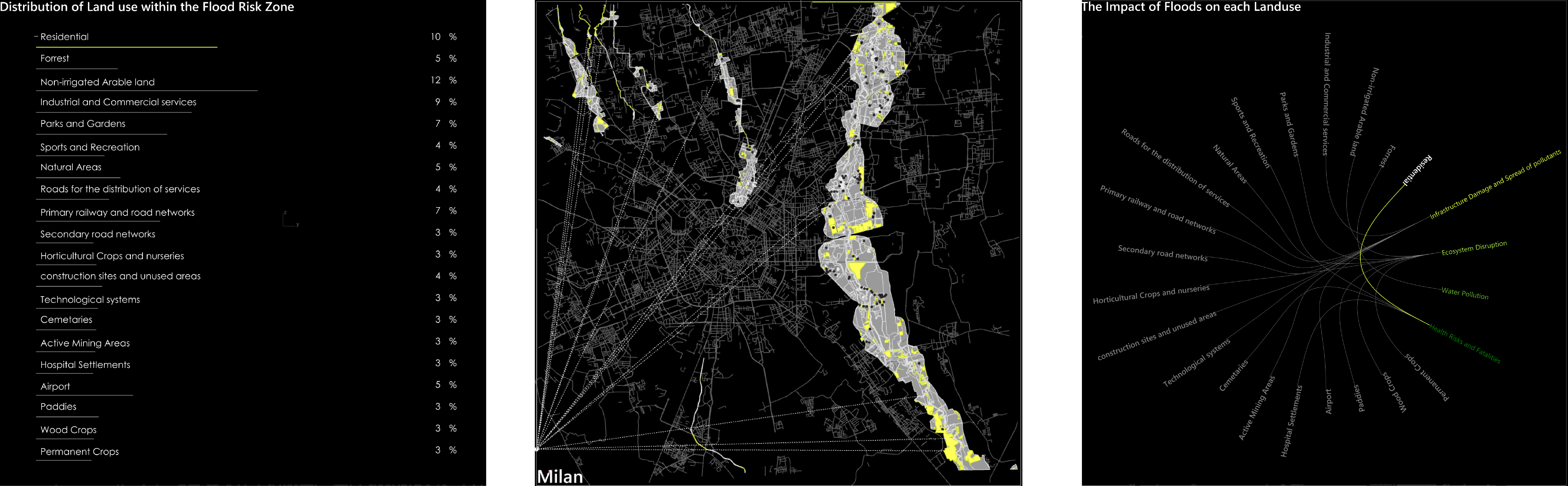
Our project envisions transforming Milan’s water management by integrating nature-based designs into urban planning. This involves addressing rapid urbanization, biodiversity loss, and inefficient water management to reinforce Milan’s connection with nature and climate adaptation strategies. The initial step includes mapping land use within flood risk zones to understand the categorization and distribution of plots in flood risk zones and the impact of floods on them. This will later help us identify what kind of interventions we need for each category of plots.

Methodology

Application and functioning
A detail analysis within an intentional framework can bring new insights to the table and help in order to drive decisions. In this case it’s not easy to go through all the possibilities. Instead, through data analysis, understanding of correlations between the parameters and data visualization you can build a documented design process and take more conscious decision.
We know that the biodiversity in the area, notable for its richness and ecological variety, faces threats from habitat destruction, invasive species, and overexploitation. This biodiversity loss is a major concern in flood management and urban planning. Drought conditions harden soil, reducing its ability to absorb water and exacerbating surface runoff and flash flooding.
Therefore, the categorization can bring us to the decision to create climate-resilient crops in agriculture that can lead to reduced water consumption and increased yields. Maintaining healthy soil is not only crucial for flood prevention but also for ensuring crop cover and agricultural stability during drought episodes. Green infrastructure offers a promising approach, utilizing natural assets for water management. This includes enhancing a city’s ability to absorb water through infiltration, absorption, and storage, while also reducing pollution in surface waters. Such nature-based infrastructure not only improves a city’s resilience against water-related disasters but also contributes to biodiversity, carbon emission reduction, and overall urban health.

