
A MULTI REALITY MUMBAI EXPERIENCE!
ABSTRACT
The ‘Interact [CITY]’ project is aimed at providing a comprehensive understanding of Mixed Reality technologies and their building blocks through a practical exploration of Augmented Reality (AR) using the Unity Engine. The focus of the project was to examine the different applications of AR in the creative process of urbanists, ranging from the design phase to the realization phase. The project provides a unique opportunity to understand the potential of AR in shaping our urban spaces, and the impact it can have on the future of urban design.
INTRODUCTION
The Rain Reservoir Project is an exploration of adapting avant garde interactions developed at IAAC for the Design for Fabrication and Interaction. Using data as a mediator of aesthetics to inform a curation of climate actions. The aim of the project is to highlight climatic vulnerability of Metropolitan Mumbai via fabrication through a multimedia interaction of materials actualized via laser cutting, CNC, 3D printing and Video Mapping.
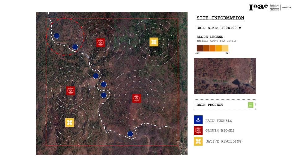
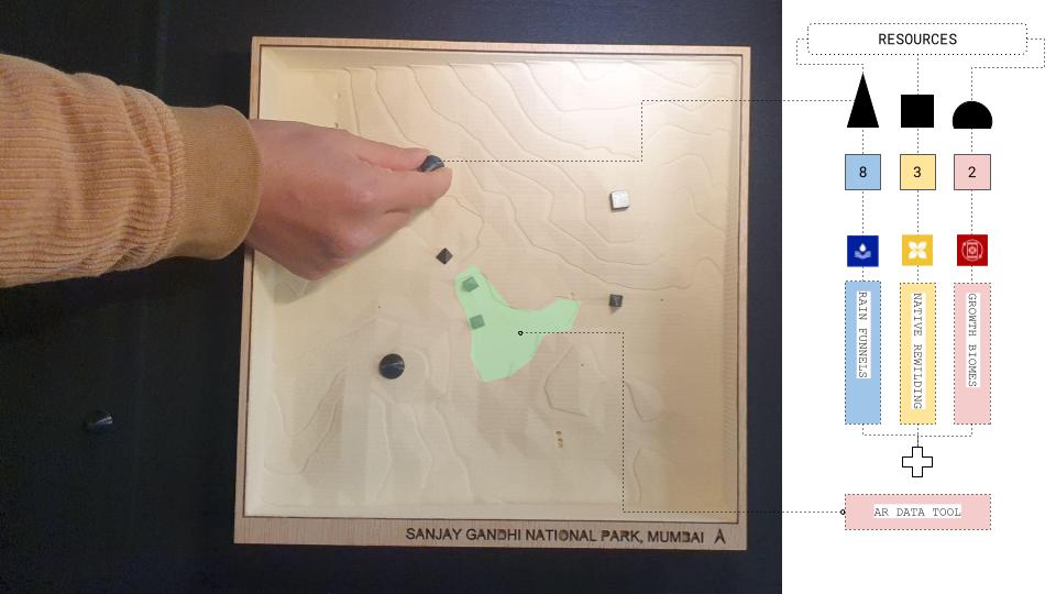
The Rain Reservoir project is an initiative that focuses on enhancing the overall ecosystem and addressing ecological vulnerabilities through the endorsement of three critical interventions – rain funnels, growth biomes, and native rewilding. Data analysis of different ecological vulnerabilities was conducted to determine the most pressing environmental issues, and the potential of these interventions was assessed to manage water resources and biodiversity. The rain funnel intervention collects rainwater through a network of strategically placed funnels, ensuring the preservation and reuse of this precious resource. The growth biomes provide habitats for a diverse range of species, promoting biodiversity and fostering a healthy ecosystem. The native rewilding intervention restores degraded areas to their original state, utilizing a combination of indigenous plant species and wildlife to rejuvenate the area.
INTERACTION
The transition into AR interactions in the project was a crucial step in promoting a global level understanding of Mixed Reality spectrum technologies and their building blocks. The use of AR allowed for a practical exploration of the technology and its applications in the creative process of urbanists, from the design phase to realization. The need for AR interactions in this project arose from the need for a more immersive and interactive experience for users, allowing them to better understand and engage with the data and the interventions being proposed.

The first MR experience developed for the project was a topological map of Sanjay Gandhi National Park and Mumbai. This map was created using the Unity Engine and incorporated topographical data to accurately represent the terrain. The map provided an interactive experience for users, allowing them to explore the park and the city in an immersive, three-dimensional environment. The integration of large amounts of data was a significant challenge encountered while operating the software, requiring significant processing power and time.
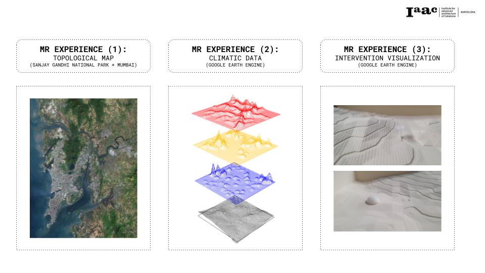
The second MR experience developed was the visualization of climatic data from Google Earth Engine in AR as meshes over the model. The climatic data was integrated into the Unity Engine and visualized as three-dimensional meshes, providing users with a real-time, interactive experience. The integration of the data and the creation of the meshes proved to be challenging, requiring a high level of technical expertise and extensive processing power. Despite these difficulties, the visualization was crucial in promoting an increased understanding of the environmental impact of climate change and the need for eco-friendly interventions.
WHAT’S NEXT?
The potential for developing the project as a game in the future is exciting and holds great promise. By integrating motion detection and data-driven decision making, the project can help the municipality build an accurate model for interaction. The use of these technologies would enable players to explore and manipulate the augmented reality environment, engaging with the virtual world in real-time. As they interact, data and feedback can be collected, providing valuable insights into the impacts of various interventions on the ecosystem.
The game could include elements of strategy and problem-solving, where players must make decisions about the placement of rain funnels, growth biomes, and native rewilding based on real-world data and their understanding of the topological map of Sanjay Gandhi National Park and Mumbai. These decisions would have real-world consequences, and players would have to balance the need for water management and biodiversity conservation with other competing interests such as urban development.
The game could also include educational components, teaching players about the complexities of urban ecology and the importance of environmental sustainability. By presenting this information in an interactive and engaging format, the game could inspire players to make more informed decisions in their own lives and contribute to a more sustainable future.
Overall, the development of the project as a game has the potential to be a powerful tool for promoting environmental awareness and sustainability. The combination of motion detection, data-driven decision making, and engaging gameplay could make the project a valuable educational tool and a catalyst for positive change in the real world.
