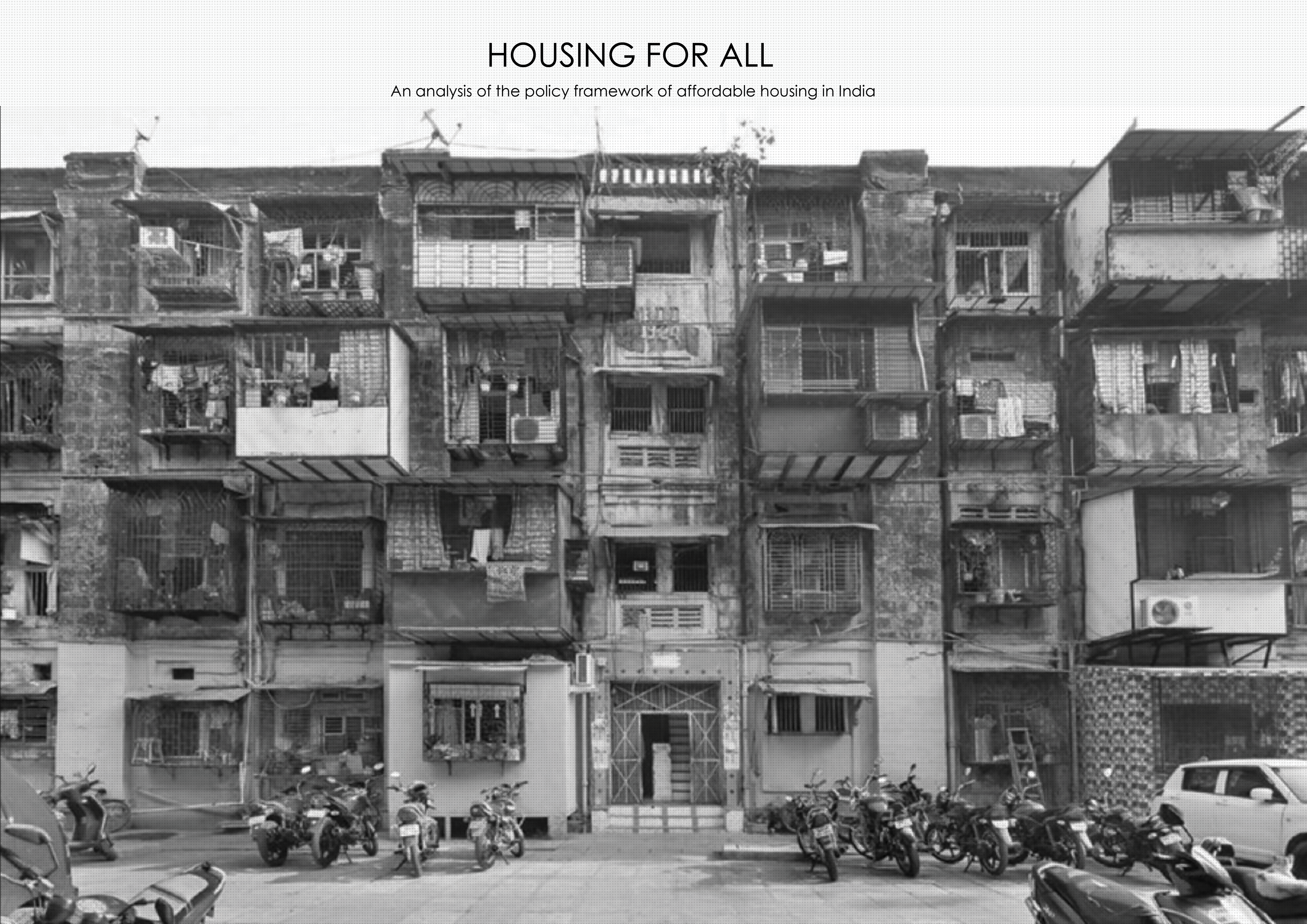
IAAC’s Master in City & Technology (1 or 2-year program) is a unique program oriented towards redefining the analysis, planning, and design of twenty-first-century cities and beyond. The program offers expertise in the design of digitally enhanced, ecological and human-centered urban environments by intersecting the disciplines of urbanism and data science. Taking place in Barcelona, the capital of urbanism, the Master in City & Technology is training the professionals that city administrations, governments, industries, and communities need, to transform the urban environment in the era of big data.


Filters
Course

The Green Ally

In Spain, there is an urban myth, according to which – The country was once so thickly forested that a squirrel could cross the peninsula hopping from tree to tree. -However, this condition has changed throughout the years, both in terms of the natural environment and the existence of squirrels in Spain. The case study … Read more

City of Proximities: Public Markets in Madrid

Madrid Public Markets SystemThe toolkit for municipalities, food delivery platforms and local residents 1/ Overall PerspectiveA first overview of the city of Madrid, throughout its administrative districts, their socio-demographics variables, the location of 46 municipal markets and the proximity patterns between them. 2/ Markets Around the Clock To allow citizens to engage with the markets … Read more

The Wild Deal

ABSTRACT Urban Rights is a term which has been coined by the philosopher Henri Lefebvre (Lefebvre, 1967)  and further explored by David Harvey (Harvey, 2003). It is a concept of a collective right to change the city and shape the process of urbanization. Thus, the right to the city does not merely address what the … Read more

Healthcare BCN

Understanding and analysing the existing Healthcare system of Barcelona with the help of open datasets available. This further helps us to understand the robustness, need and requirement to fill the gaps in the system if any with respect to their typologies and location as per districts Step 1: Documenting the distribution of different types of … Read more

A Parallel City for Pollinators

Introduction to Pollination The project attempts to study and research the possibilities of creating a green, three-dimensional corridor for pollinators in a specific area, the historical city center of Madrid, connecting Madrid’s most prominent green park “el Retiro” in the east to the “Casa de Campo” natural reserve in the west. In particular the proposal … Read more

It’s Not About the Skyline, It’s About the Base Condition

There is no unambiguous definition of the tall building (skyscraper) in the world. A tall building is one that dominates in the landscape through its scale, so it does not have to be significantly high, but it is prominent above the surrounding buildings. As a consequence, the term “tall building” is relative to the environment … Read more

Urban Data Visualisation – Barcelona and Brazil

The aim of this studio was to explore the design opportunities arising from three common digital fabrication processes: Laser Cutting, CNC milling and 3D Printing. These exercises were supported by an interactive exploration of each technology and material, while also understanding conceptual and prototyping process of design. 1. Laser Cutting The first digital fabrication exercise … Read more

“Water Bodies towards crisis management”

Potential Conflicts related to flooding phenomena in highly urbanized and agricultural areas.

Almost every day, we are confronted with dramatic images of communities and environments incrisis . Flash floods have recently become one of Greece’s most common natural occurrencesafter wildfires. Flooding occurs due to rapid rainfall and heavy storms, from rising river levelsor melting snow.Deforestation, poor soil quality and rapid urbanization significantly contribute to the genesis of … Read more

HANDS OVER BEIRUT and GREEN’IN CORRIDORS

HANDS OVER BEIRUT Beirut Blast impact assessment visualization Neighborhood: Mar Mikhael (Beirut port)/ Gemmayze – Bashoura – Ashrafieh The Area chosen has received the most impact and visualization of the plot of land where buildings got damaged but on a different scale is relevant to understand the shock wave repartition. To physically be able to … Read more

growing sidewalks

Poblenou, Barcelona The project focused on a specific site in the district of Poblenou, which has been identified as the one who has the most problematic street conditions. Traffic accidents, asphalt, no liveability and no safety. “Growing sidewalks” proposes a design strategy to change this, projecting into the needs of the future. Site overview and … Read more

Adventure in Tokyo Rivers

Intro What’s your first impression of Tokyo?  A lot of people would say skyscrapers, high-technology, cherry blossoms, etc. When we search for pictures of Tokyo, we can see high-rise buildings filling the city horizontally. This could give people the impression that Tokyo is flat. However, Tokyo is a city with a lot of hills. We … Read more

Benidorm 360

A new ecosystem for a global tourism destination Benidorm, Alicante The city of Benidorm is the most renowned mass tourism destination on the Spanish Mediterranean coast. It has been recently acknowledged as a sustainable urban development to support the mass-tourism industry; however, Benidorm had received strong criticism during many years, mainly because of its striking … Read more

3 CITIES

Cities face complex challenges, amplified by the unparalleled urban growth testing traditional municipal and regional boundaries. Cities have evolved into metropolitan regions, complicating the optimization of city services, e.g. transportation, infrastructure, and public service. The evolution of cities and their urban forms are ever-evolving in a direction that induces higher car dependency and longer commuting … Read more