
La Barceloneta is one of the most popular neighborhoods in Barcelona. This old fishermen’s neighborhood forms an inseparable entity with the beach of the same name and is synonymous with a lot of charm, food gastronomy, old traditional pubs and a very lively atmosphere. The aim of the proposal is to identify the streets that can be transformed into pedestrian friendly zones.
Site Overview and Analysis
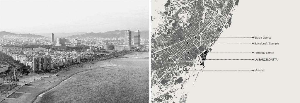
Over the years, La Barceloneta has gone through a transition from an old fishing village to a streets filled with hustling and bustling of tourists visiting the city because of its strategic location between the beach and the other residential neighbourhoods like Ciuta Vella, Eixample, Gracia and Historic City center making it a very popular neighborhood even amongst the locals.
Accesibility to the site
The site is very well connected from the surrounding areas of the city through different modes of existing public transport network like bus and metro combined with cycling tracks. The neighbourhood features homes that are simple as can be with very few balconies to be seen. Plenty of expats and immigrants live in the tiny, simple flats. It’s one of the few places with houses on the ground floor where the people reclaim the sidewalks outside their houses to dry clothes and park cycles.
Urban Analysis
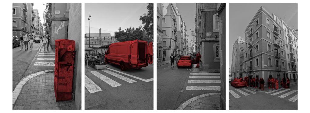
Through multiple on-site observations and analysis of the locality, Sant Carles street, which connects the beach and the neighbourhood, is identified as the area of intervention to be experiencing maximum footfall and plenty of challenges and opportunities. The street acts as a spine to the rectilinearly placed residential buildings on both sides with one way transversal movement of vehicles connecting the main road. It houses various commercial and retail activities like offices, bars, restaurants and supermarkets throughout the street with a primary school and a civic center located in the close vicinity.
Challenges and Issues
The street serves a dual character during different times of the day, in the early hours of the day the movement is restricted to services, residential vehicular flow and school buses but towards the evening the street converts into an active social space with heavy pedestrian movement. The street is 7m wide with 1.2 m wide narrow sidewalks along the residential buildings periphery with allocated parking for the residents alternating on the either side of the street based on odd-even months. Few of the major issues which were identified that called for an intervention were the narrow sidewalks with various obstructions caused by overcrowding, unplanned physical barriers like feeder pillars, trash cans and parked cycles forcing people to walk on the street.
User Types
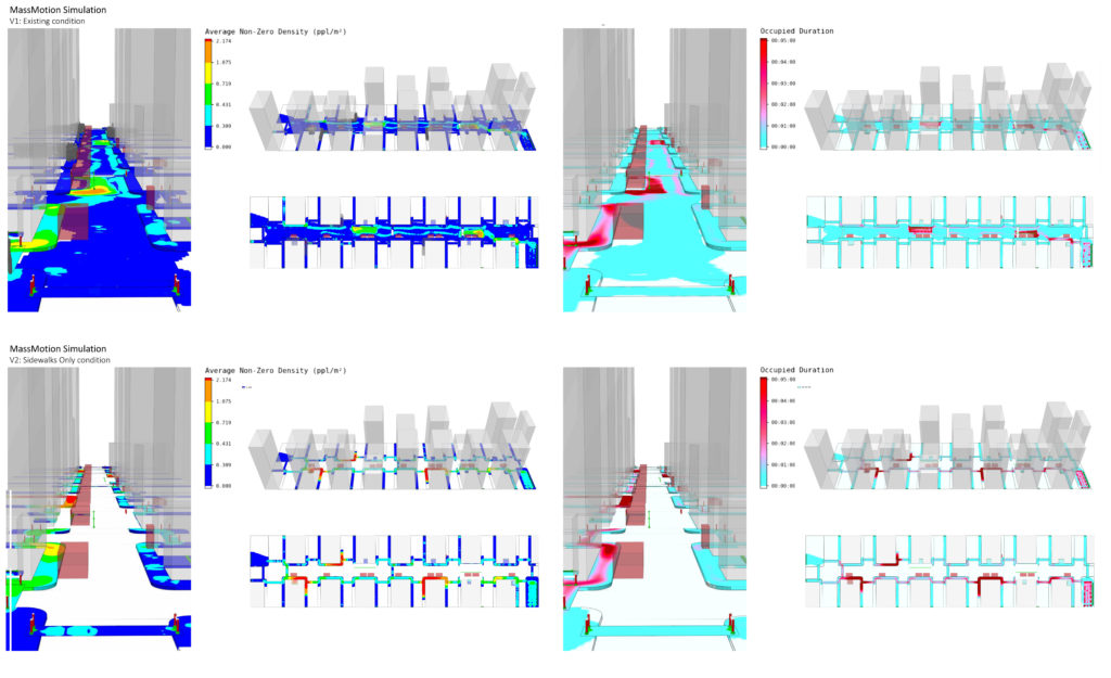
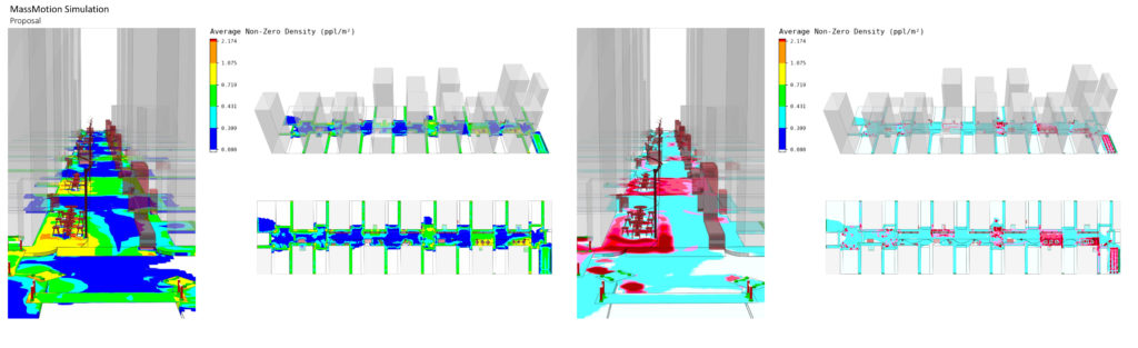
Pedestrian Flow Simulations
On the bases of these multiple factors the movement of people through the street were mapped to create an Origin Destination matrix. This matrix helps us create multiple simulations through massmotion to understand the pedestrian movement patterns. To understand these patterns further two scenarios were created which reflect the existing movement patterns and the other which depicts why the existing sidewalks are not functional.
Street Design Proposal
This led to the intervention on site through proposing a pedestrian only street through tactical urbanism, which retains its character through bifurcating the function of the street on specific time periods of the day.
Tactical Urbanism is all about action. Also known as DIY Urbanism, Planning-by-Doing, Urban Acupuncture, or Urban Prototyping, this approach refers to a city, organizational, and/or citizen-led approach to neighborhood building using short-term, low-cost, and scalable interventions to catalyze long-term change.
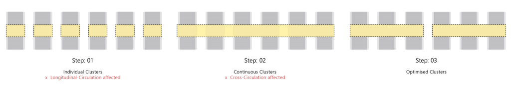
Three different approaches were considered in order to identify the most optimum way of implementing the project through clustering.
The toolkit provides a road map for undertaking the project and is meant to spark thinking, communication and collaboration. It also explores low cost methods like recycling and reusing materials in different possible ways. An element of continuous urban street furniture is also which flows across the street weaving both the clusters as one acting as an element which can be used in many ways.
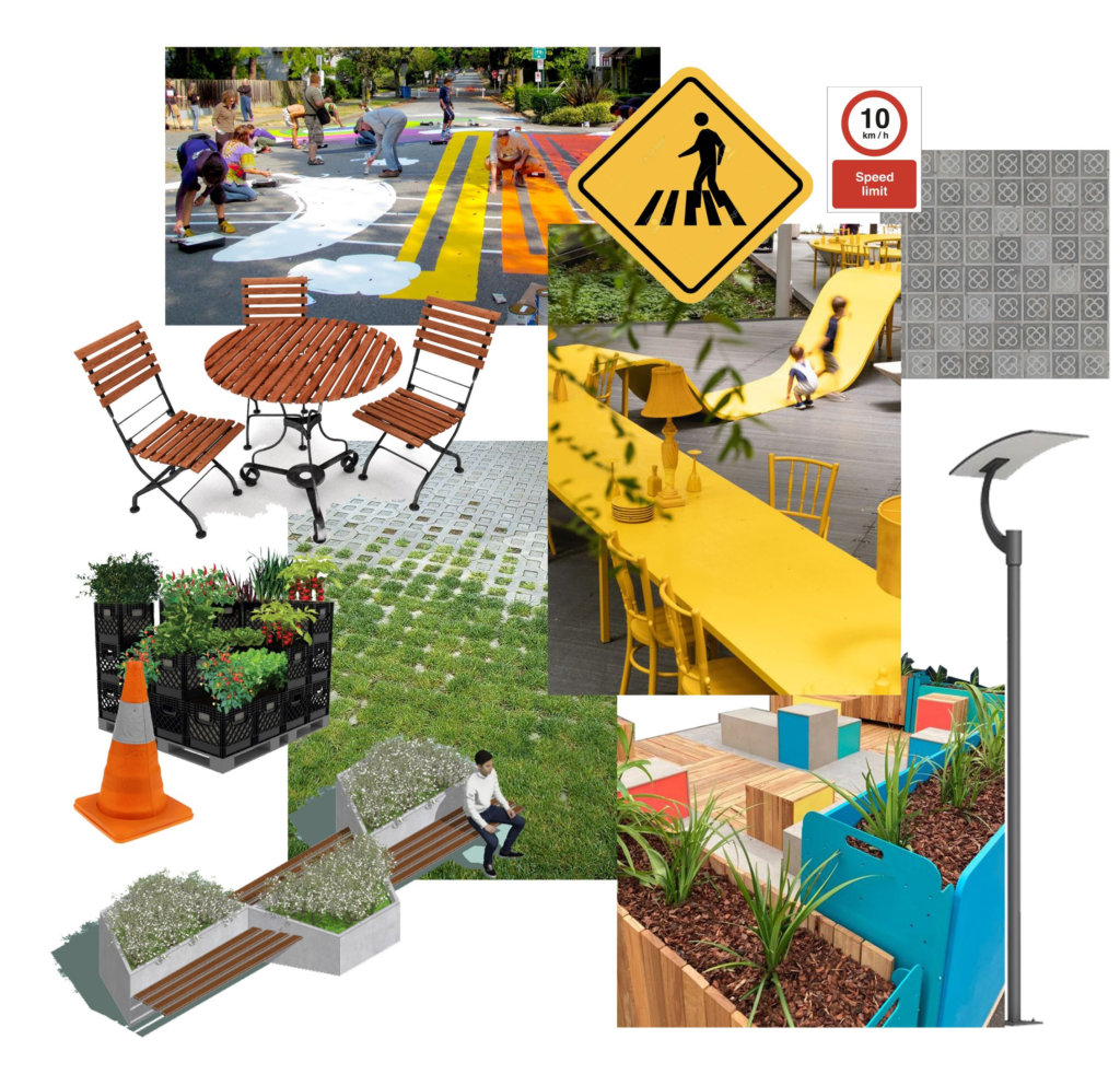
The proposal opens up the street to free pedestrian and cycle movement as one raised level along each cluster creating buffer zones for the restaurants and other activities to spread out and ease overcrowding. An alternative to typical concrete tarmac, paver block with voids which allow growth of small grass making the surface pervious can be used.
This initiative offers a unique opportunity to engage with youth, the school community, and the broader neighbourhood on what might improve safety and comfort for residents as well as the tourists,it can form a powerful sense of ownership and legacy when various parties work together to re-imagine the community spaces they share.
