My research starts from observing human behaviour. Often when we face a change in our lives, especially when it wasn’t planned, we feel resistance and it takes time before we accept and embrace it.
As you probably know Barcelona in the last few years lived some changes in its typical network. In the following animation you can see what is the typical system of traffic until the planners decided to close some intersections to traffic in order to reduce contamination and regain some urban space.
Although this sounds on paper very beneficial people’s reactions have not been always positive. When browsing on the web “superilla Barcelona” the results are controversial. For some it is a groundbreaking initiative towards a more sustainable city, for others it is just another open space for late night parties up to the point where a judge has just proclaimed the project as non valid and proposes a dismantle of the superblock to go to the previous state. Eventhough probably there is no going back my research investigates:
Is there a better way to overcome the gap between citizens and urban planners to soften controversy and embrace the urban change quicker and without contrast?
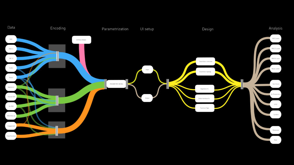
There are different routes to approach urban planning. The most common is the TOP-DOWN approach, the one adopted by Barcelona’s Municipality. What the municipality added up is a system of open data that are available and consultable by anybody giving the chance to defend their studies and design choices. The limit that I saw in this approach is that the data is very technical, static and complex for a citizen and does not really open up to an equal dialogue and confrontation. What I propose is to add to the openness of the data a model that is dynamic and contains in a simplified way and organically the information gathered by the studies to make it easier for the user to understand technically the potential of the urban plan.
Superblock BCN APP
Select WHERE and the TYPE of your Superblock Design Choose Between TYPE A: 100% Pedestrian – This option concentrates vegetation on the axisof the intersection and keeps urban furniture on the sides. TYPE B: 80% Pedestrian – This option allows vehicles with a special permit to access so it keeps the axis open, this type can be used for the green axis.
Customize the Superblock Design Control Vegetation and Urban Furniture Vegetation Density – it influences the capacity of the absorption of air contaminants and temperature. Urban Density – the type and percentages influence the noise levels and the active engagment on the block.
Air Quality and Noise PM 2.5 PM10 and db(A) PM 2.5 and PM10: the levels vary depending on location’s traffic quantity of superblocks and greenery concentration. Noise intensity varies on location’s traffic and the percentage of occupation that is estimated.
Thermal Conditions and Comfort Sun Hours, Temperature and UTCI Analysis is run through the software and data is elaborated as a comparison between the inside and the outside of the block. Relevant data to understand the benefits are temperature changes, the hours of direct sunlight and the general comfort.
Social Engagement Rest or Play Be a true urban designer designing the social aspects of urban planning foreseeing the activities you’d like to see. Single Seating benches are designed for resting and relaxing while a ping pong table is set for being active and socialize.
Conclusions
1. Enabling citizens to understand and evaluate a urban planning system could be very powerful
2. The model has to be built on diverse and rich data to be reliable
3. Creating a functioning and fast platform that includes valuable info requires strong computational power
4. The tool has to be very intuitive and rewarding to use to actually have citizen’s participation or feedback