
In Spain, there is an urban myth, according to which – The country was once so thickly forested that a squirrel could cross the peninsula hopping from tree to tree. -However, this condition has changed throughout the years, both in terms of the natural environment and the existence of squirrels in Spain.
The case study city of the project is Madrid.
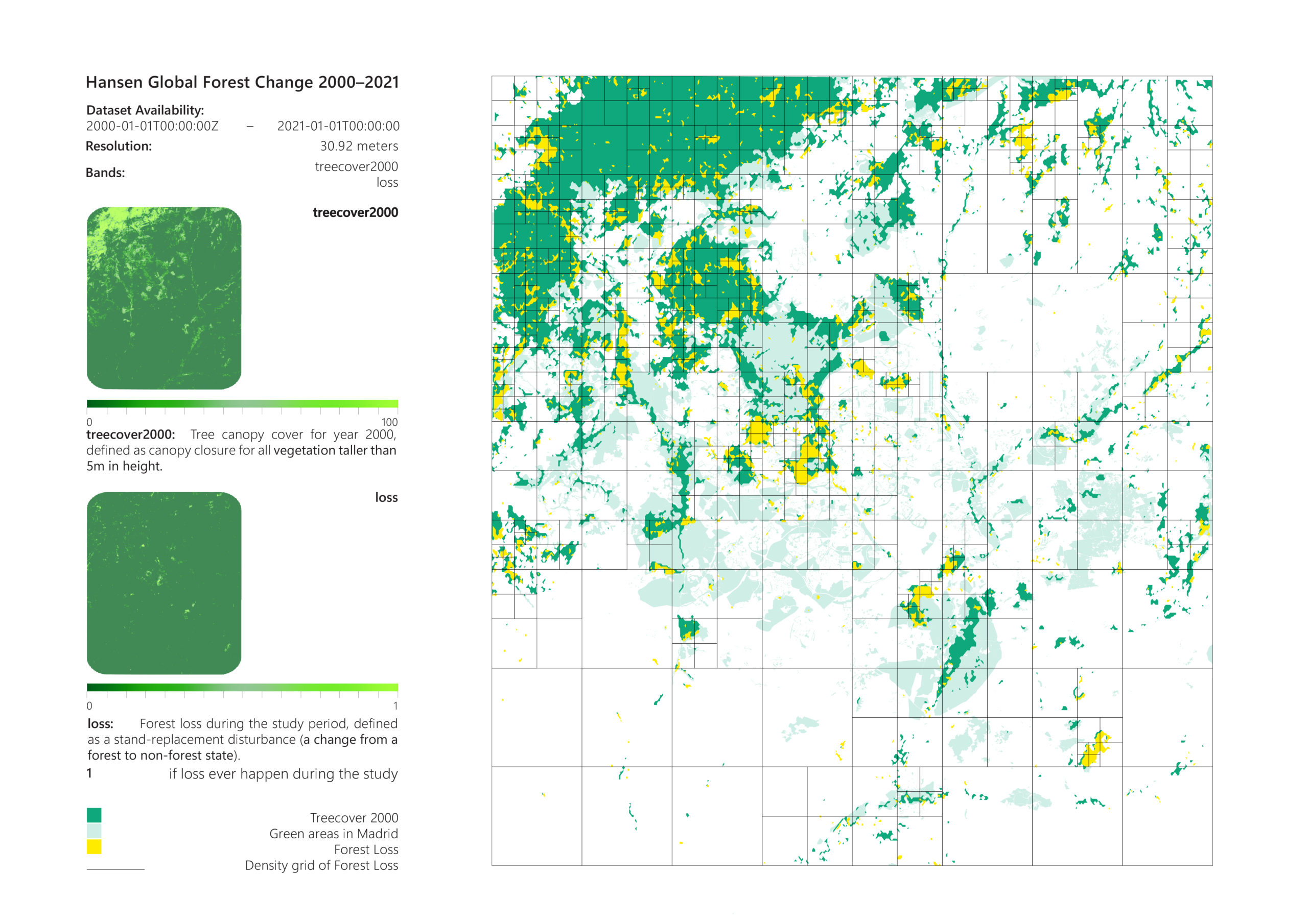
Focusing on the first point that the urban myth highlights, about the forest condition in Spain and using data from the Global Forest Change dataset of Google Earth Engine, the forest areas in Madrid as well as the loss part of them, between 2000 and 2021, are identified. The adverse effects of infrastructure projects, built up areas, agriculture, unsustainable forest management and wildfires have led to this crisis. Urbanization and the environmental conditions caused by climate change have a severe impact on the natural environment. Apart from that, UHI deteriorates the existing conditions by contributing to higher daytime temperatures and reduced nighttime cooling. This consequently leads to habitat fragmentation and habitat loss, which decreases biodiversity and alter species ranges and interactions. The loss of natural habitat makes some animal species vulnerable to adjust to the new conditions. More precisely, in regards to the reference city, squirrels are species under extinction in Madrid.
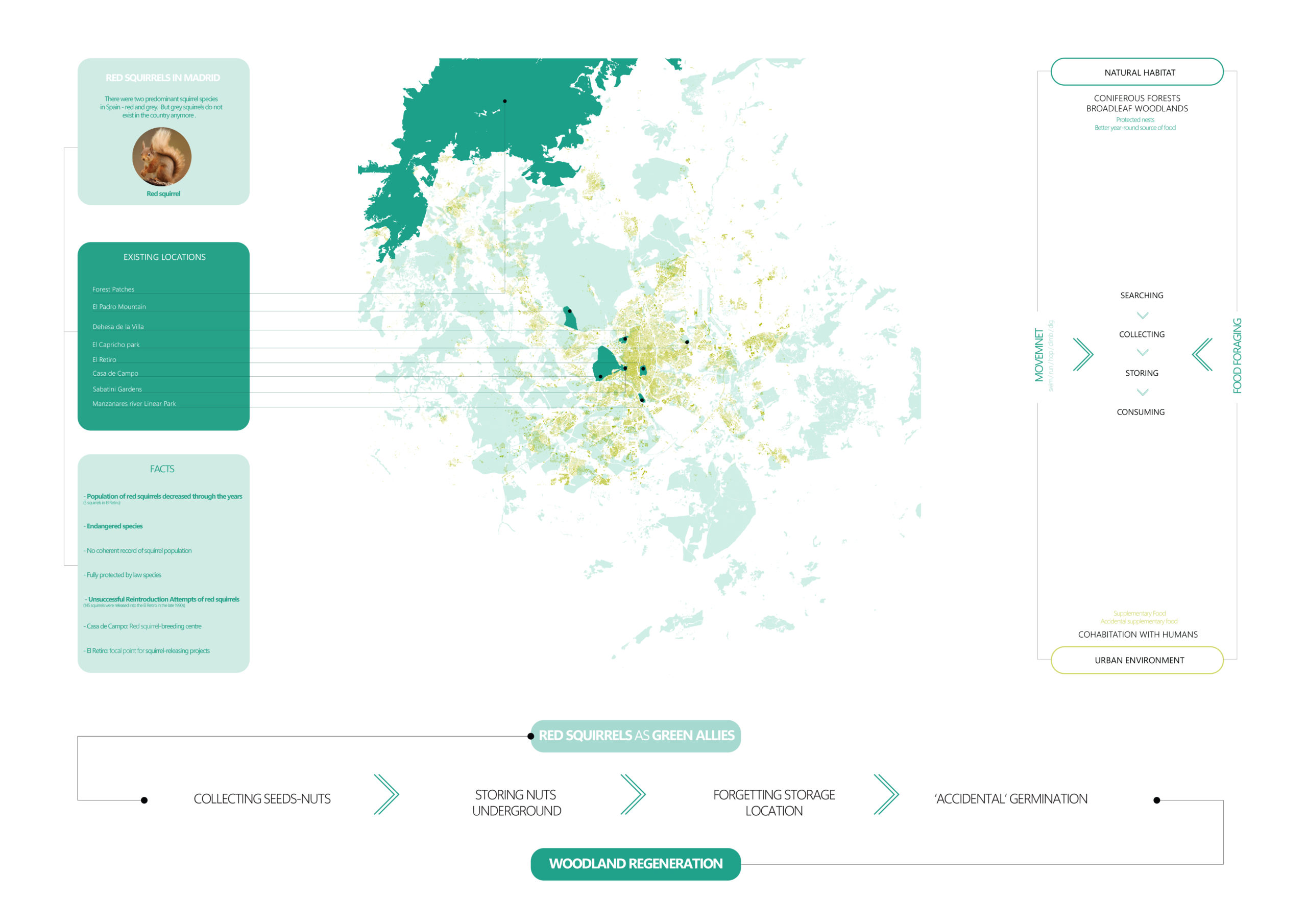
There are two predominant squirrel species in Spain – red and grey. In Madrid, grey squirrels are absent which is fortunate because grey squirrels are detrimental to red squirrels. Casa de Campo and El Retiro have attempted to protect red squirrels through breeding centers and squirrel-releasing projects, but it has been in vain.
To shine more light in squirrels’ way of life , their main activity is food foraging. For this reason, their movement is steered by collecting, storing, consuming and searching for food. Their natural habitat (conifers, broadleaf woodlands), combined with availability of diverse food indicates the strong relationship between red squirrels and trees. On the other hand, in the urban environment, squirrels adapt quite well as they are friendly with humans and see them as a source of food. They collect food by scavenging as well. However, their most important behavioral trait is the role they play in the ecosystem. Picture a scenario where a squirrel collects nuts and stores them underground. Since they are quite forgetful, they lose track of the storage location and repeat this process. Nevertheless, the forgotten seeds accidentally germinate and in turn leads to woodland regeneration, making them our ‘green allies’. This process is known as zoochory.
The aim of the project is to tackle the issue of urban heat island effect in Madrid by creating a synergy between squirrels and humans. The red squirrel’s forgetful quirk can be utilized efficiently to re-green the city as well as revive their natural habitat. The focus of this proposal is to create an ecological corridor that connects the green nodes in the city and subsequently activate the underutilized spaces.
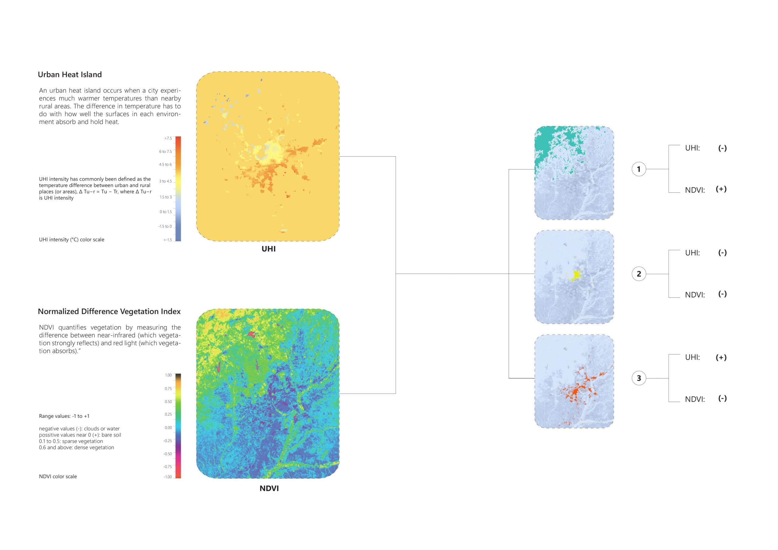
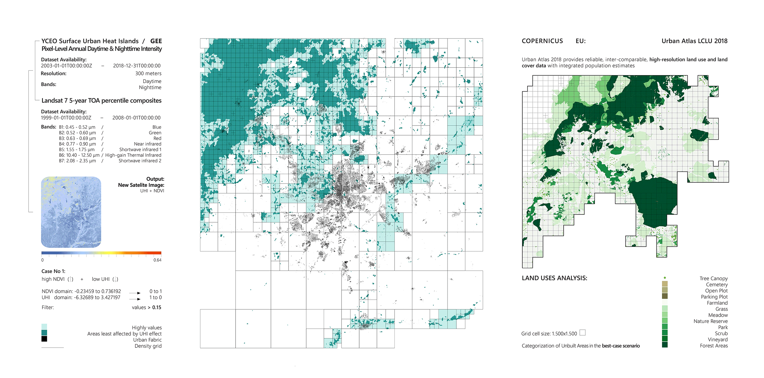
The analysis begins with the geospatial datasets from Google Earth Engine for the Urban Heat Island and the Normalized Difference Vegetation Index. Using computational design tools, the two datasets are compared, combined and filtered and 3 cases for the urban conditions in Madrid are generated:
1. Best-case scenario: High NDVI, Low UHI | 2. Route of Action Low NDVI, Medium – low UHI | 3. Area of concern: Low-medium NDVI, High UHI
In each of the three cases, the land use analysis takes place afterwards, focusing on the unbuilt areas and through this process the physical potentials and challenges of the city are revealed.
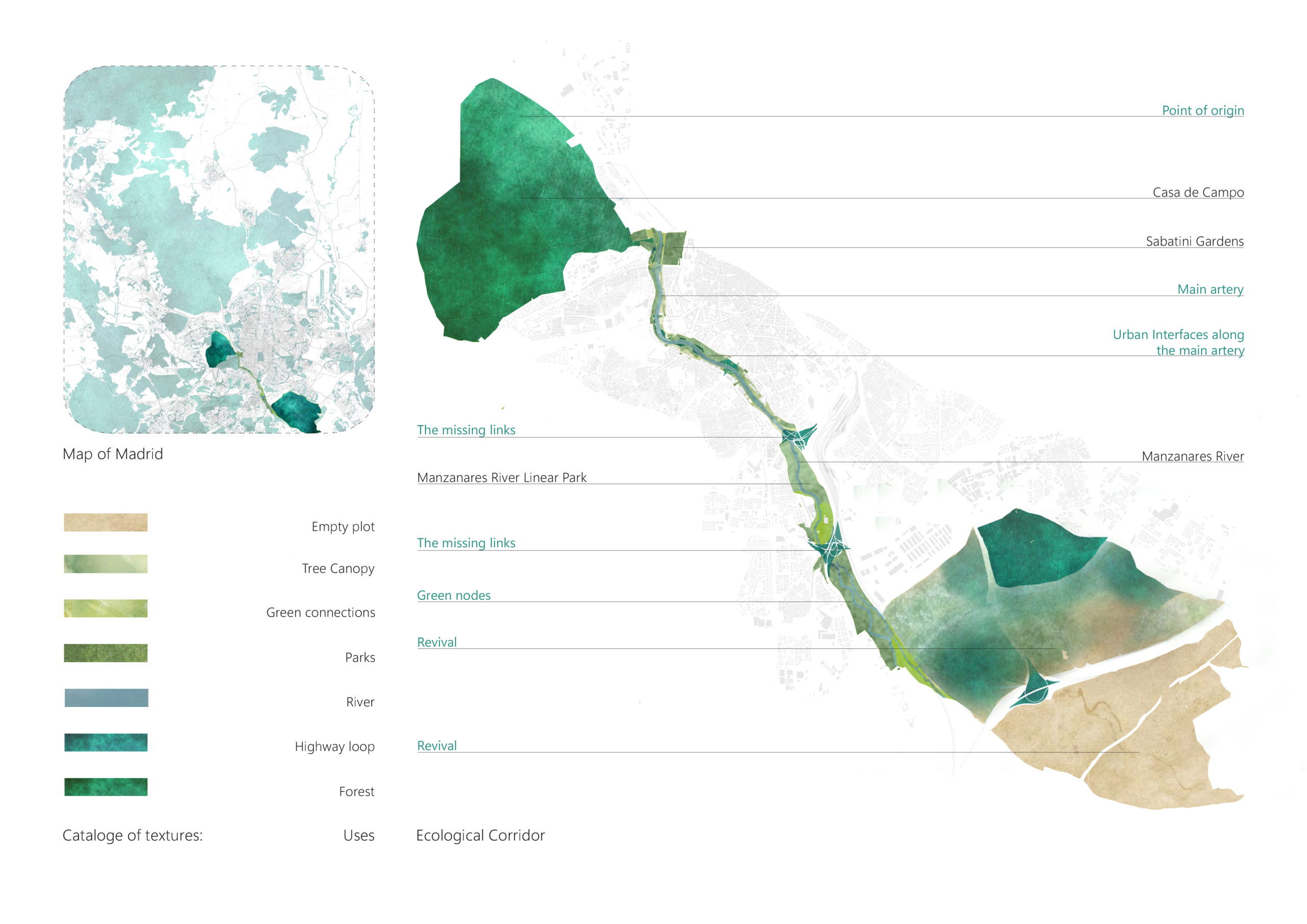
With the aim to identify the ecological corridor, the methodology is based on a scale-down process. The process starts from UHI-NDVI analysis along with the land uses analysis, it continues with the generation of a connectivity map and based on specific parameters it concludes with the identification of the ecological corridor.
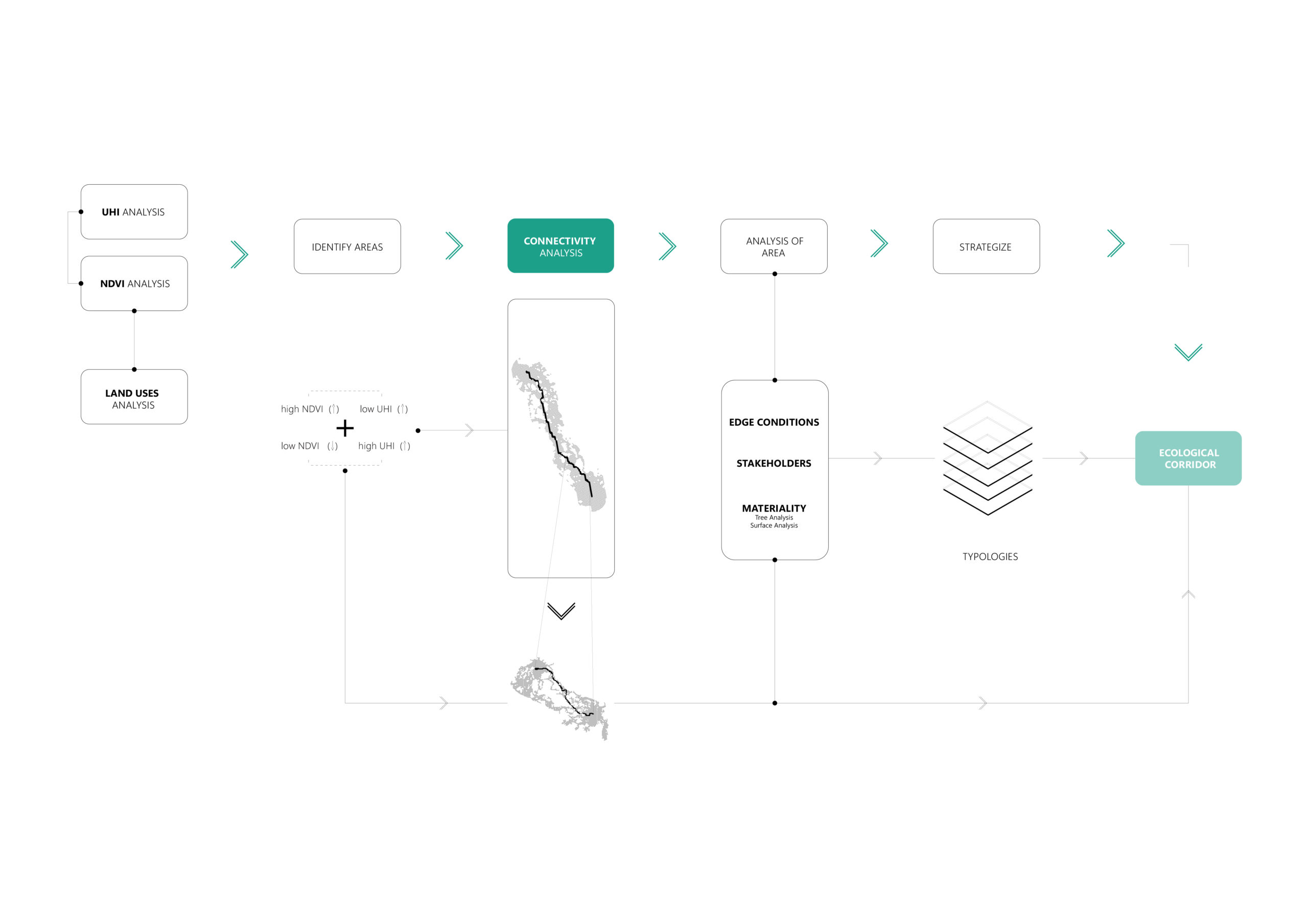
The concept is to replicate the best-case scenario in the area of concern. In order to do this, we derived focal points from the two cases, we assigned different resistance for squirrels to each land use and ran a simulation to analyze the connectivity between these two points. The simulation unveiled the path of least resistance based on the land use of the city. This process allowed us to see new connections and new intensities, helping us to identify an area with high potential connectivity. Narrowing down to the area of concern, a second connectivity analysis was conducted, which further defined the corridor.
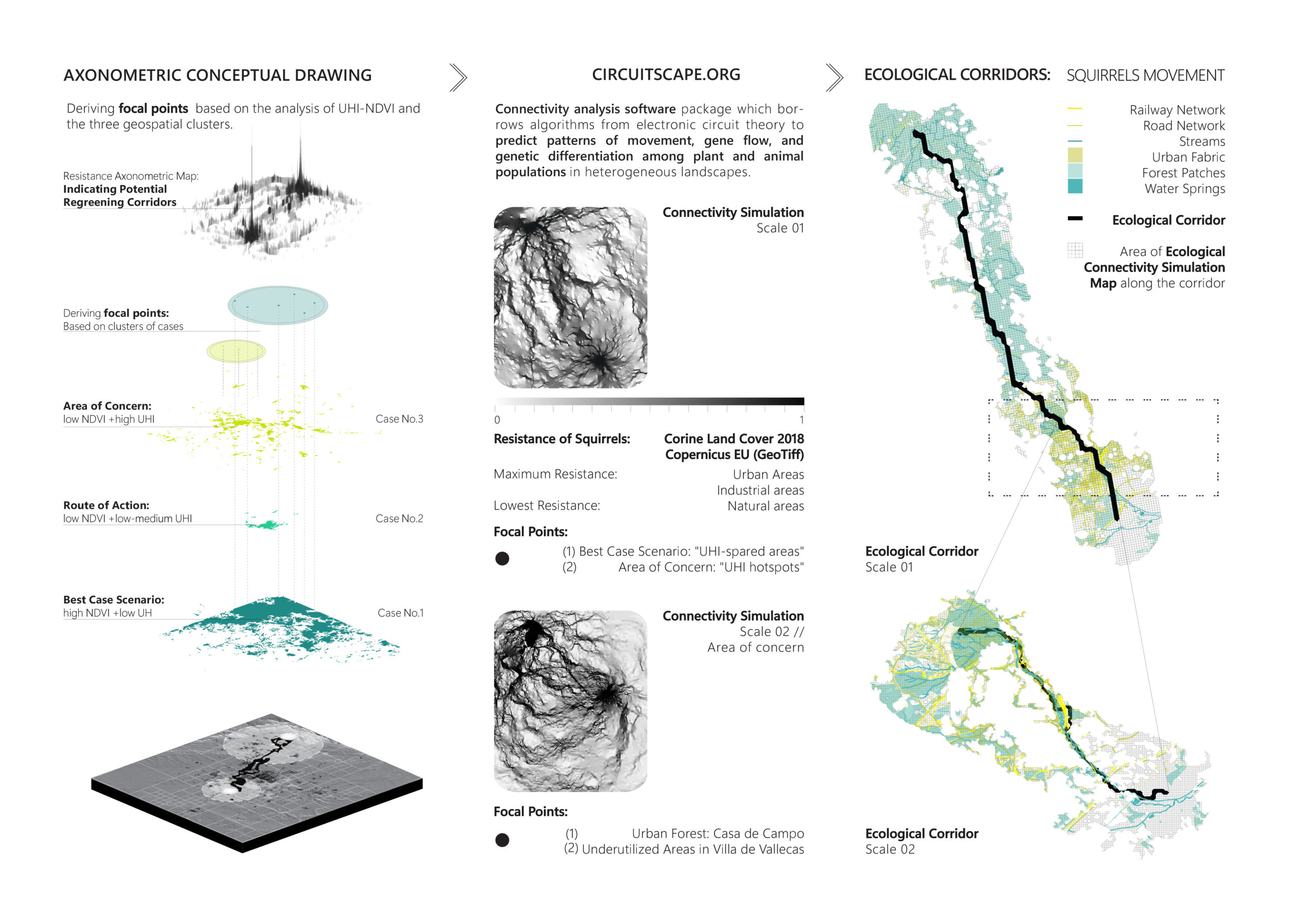
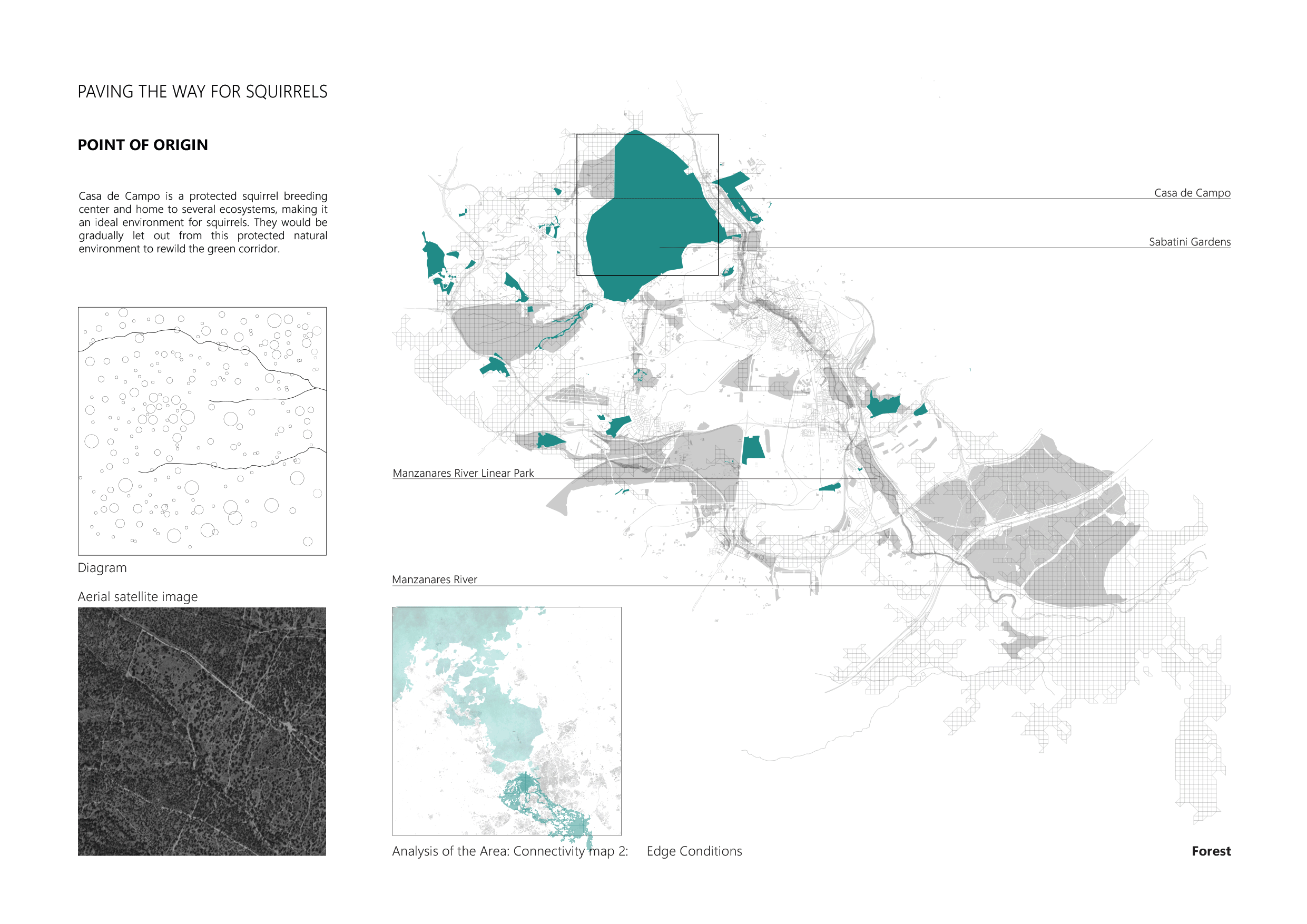
Upon identifying the connectivity map, in the entire area along the highest connectivity path, we identify the edge conditions in order to help us defining the ecological corridor precisely.
- Point of origin: Casa de campo is a protected squirrel-breeding center and home to several ecosystems, making it an ideal environment for squirrels. They would be gradually let out from this protected natural environment to rewild the green corridor.
- The main artery:The river Manzanares flows along the corridor forming several interfaces in the urbanized area.
- Urban Interfaces along the main artery:
- Street network: The street interface includes pedestrian boulevards and vehicular movement. The ecological corridor would navigate through it without hindering the urban flow.
- Bridges: The bridges although intended for human connectivity, can be a shared link that would help the ecological network as well.
- Public Spaces: Public spaces along the river are the boulevards and plazas. These spaces act as a respite for squirrels as the move through the urbanized area.
- Surfaces: The materiality of surfaces determine the density of vegetation. The non-permeable surfaces along the river would be transformed to increase connectivity, prevent water run-off and reduce UHI effect.
- The Missing Links: Highways weave the urban fabric but disconnects the natural habitat. The islands formed by highway intersections hold potential for regeneration.
- Green nodes:The parks are the connecting points along the corridor. The squirrels would be introduced in these areas to further rewild and link the green nodes.
- Revival: The empty plots, which are a major contribution to high-density UHI effect, is the journey’s end. Activating this land to facilitate forest regeneration and squirrel habitat is the main purpose of this proposal.
For the next step that will help us to strategize the design interventions, three aspects were considered:
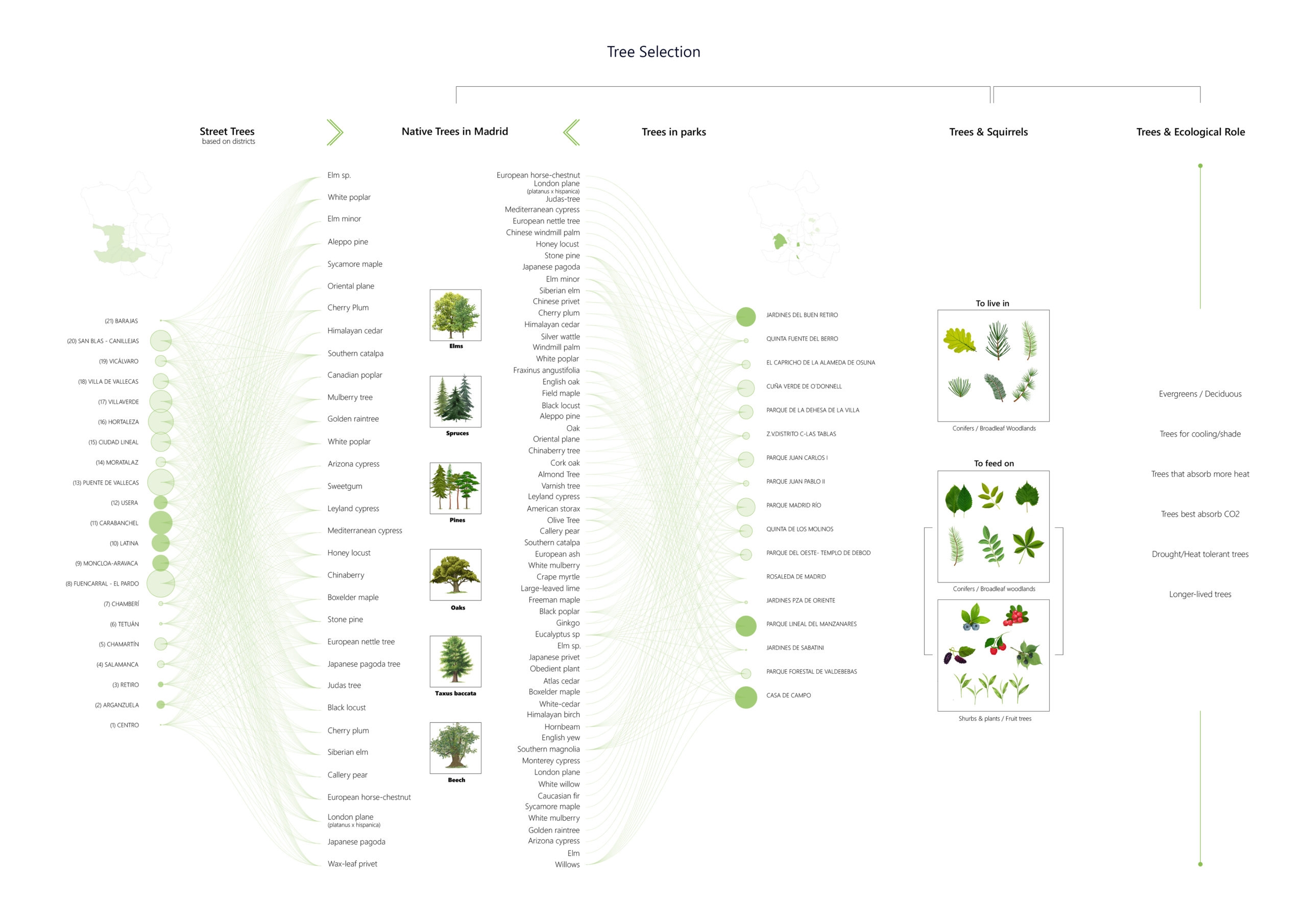
- Tree selection matters. Although urban trees are a great tool for reducing UHI and the impacts of climate change, they need to live to be effective! To this end, the diversity of tree species in an urban area is important, with native trees often hardier to these areas. Based on data from datos.Madrid and with the aim to determine the type of tree species for each edge condition, we mapped the existing tree species both in parks and streets and we identified the indigenous species, their benefit to squirrel habitat regeneration and their ecological role as well.
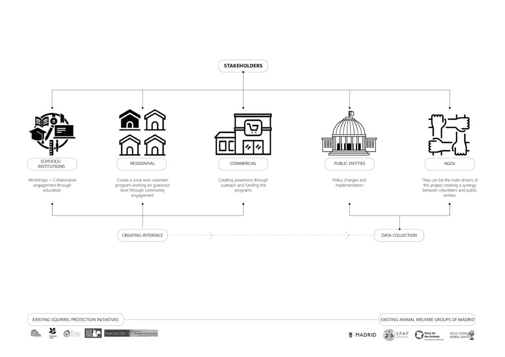
- Stakeholder analysis: Each type of stakeholder plays a different role in the edge conditions of the corridor. We identified the various stakeholders that hold the potential to carry out the proposed strategies.
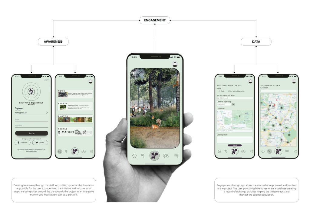
- App Development: Creating awareness through the platform, putting up as much information as possible for the user to understand the initiative and to know what steps are being taken around the city towards the project in an interactive manner and how citizens can be a part of it. Engagement through app allows the user to be empowered and involved in the project. The user plays a vital role to generate a database creating a record of sightings, activities helping the initiative track and monitor the squirrel population.
For the proposal, we devised a design framework based several aspects that would determine the performance and physicality of each edge condition.
- Activated by Humans: Certain areas that have little or no vegetation would require human intervention.
- Breeding ground: Squirrel breeding areas would have to be in locations that are undisturbed by human activity but require protection.
- Performance: A preemptive analysis of the edge condition performance was carried out based on its impact on the UHI effect, human cohabitation and re-greening strategies.
- Squirrels equipment:
- Shelters – Human made shelters in areas of cohabitation
- Feeders – Feeders located at intervals based on the activity and food availability
- Water – Water availability of the area
- Cables – To commute across the river or highways that have less vegetation and prone to accidents.
- Stakeholders: The type of stakeholders that would intervene in each edge condition and the role they play.
- App building: The type of information that would be beneficial for the app in terms of data collection and community engagement.
- Materiality: The selection of tree species and intervention of the permeability of the land.
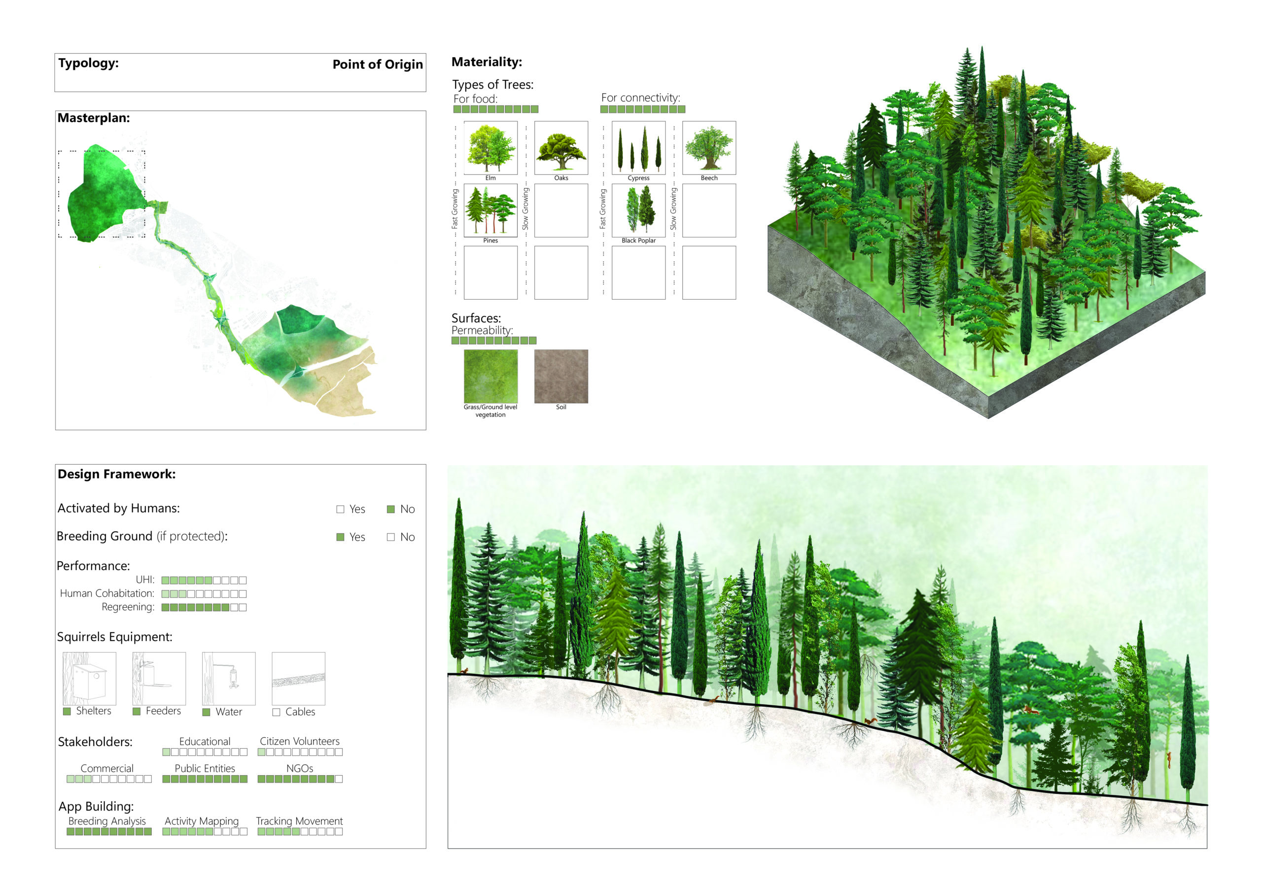
- Point of origin: The forest area is a protected breeding ground for squirrels with provision for shelters, feeders and water, making it an ideal natural environment. The main performance of this edge condition would be squirrel re-greening strategies to increase biodiversity in the area. The tree species were selected based on increased connectivity and to provide a range of diverse food for squirrels.
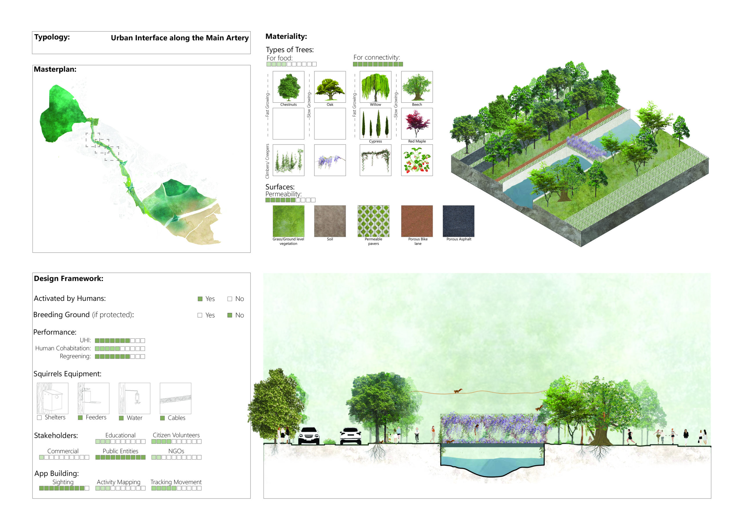
- Urban interface along the Main Artery: The river Manzanares flows along the corridor forming several interfaces in the urbanized area. Humans would activate these areas and squirrels will further carry out the re-greening. The intervention in these areas would minimize UHI and increase connectivity for squirrels. The permeability of pedestrian areas would also be increased to enhance vegetation.
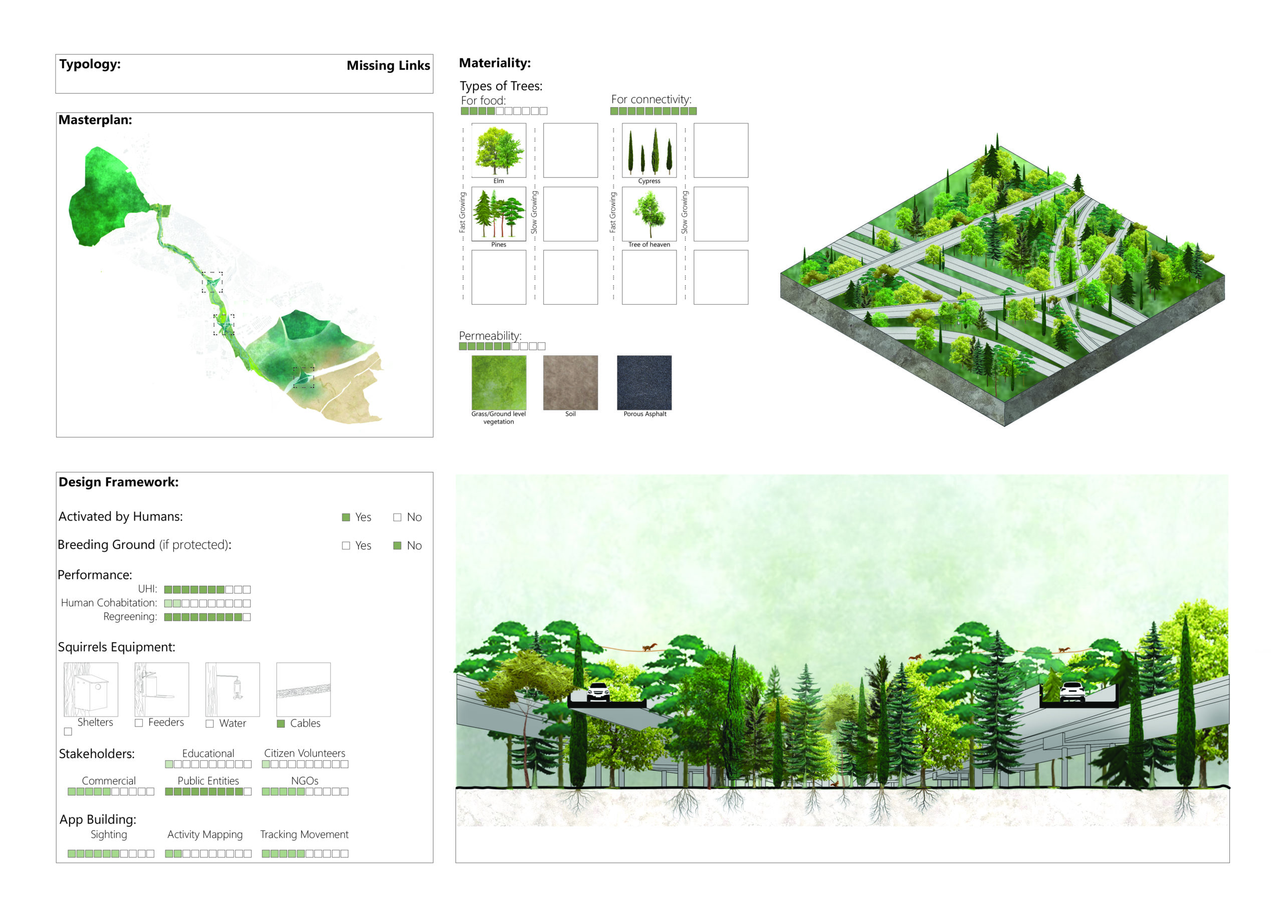
- The Missing Links: Humans would activate the highway islands and its purpose would be to act as connecting links. Cables would be provided to facilitate squirrel movement and help them re-green the area. This would significantly reduce the impact of UHI.
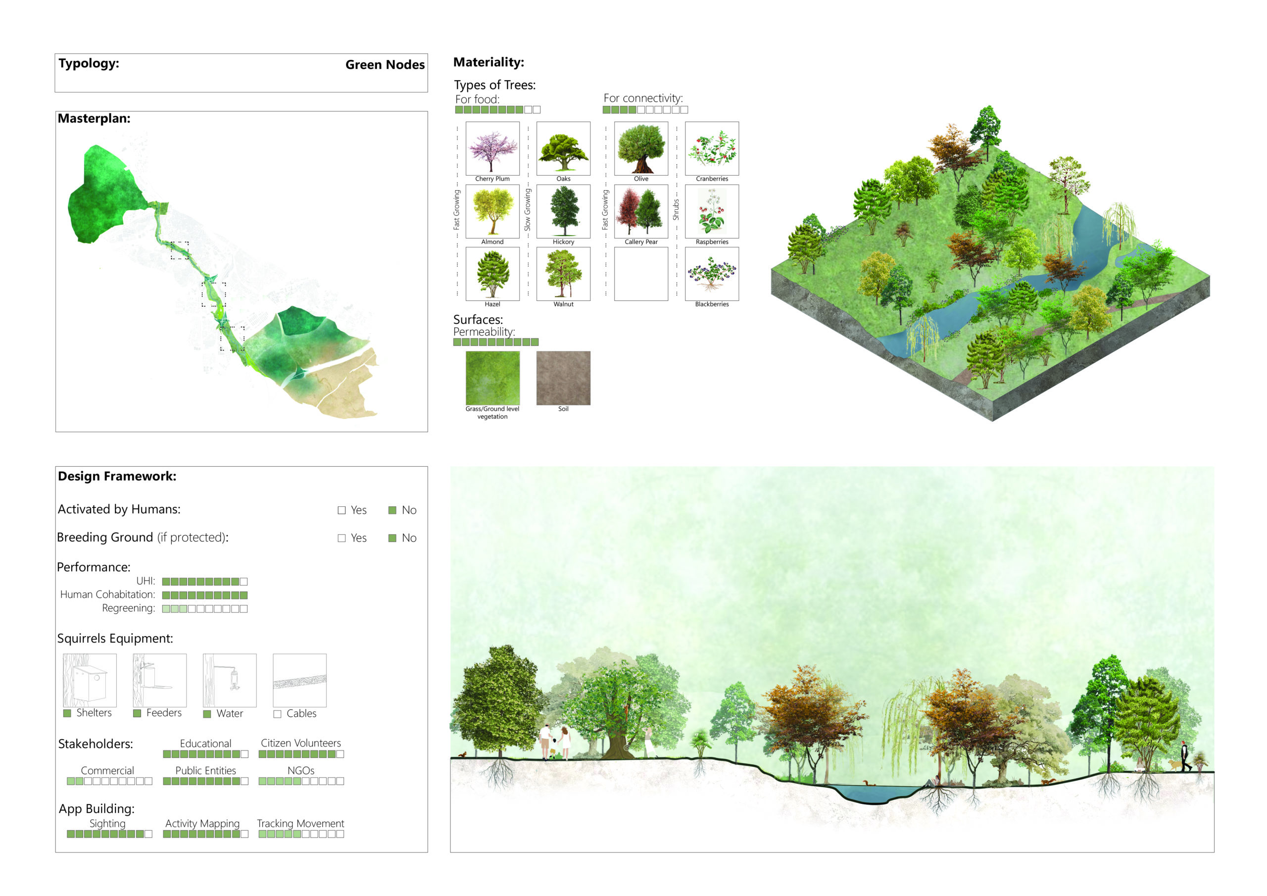
- Green nodes: The parks are the connecting points along the corridor. These areas would focus on human-squirrel cohabitation. It would have an educational agenda for children and researchers. Provision of shelters, feeders and water would attract the squirrels and enhance their interaction with humans.
- Revival: The empty plots would be activated by humans and will be utilized as a squirrel breeding ground as well as human-squirrel interaction zones. It holds the potential for citizen volunteering and breeding analysis. The materiality of the space would also be altered to accommodate ground level vegetation. Being the main area of UHI effect, activating this underutilized land is an important part of the proposal.
By creating a connection between the green nodes and designing strategies to make the movement of red squirrels a seamless one, this proposal aims to minimize the adverse effects of urbanization and habitat fragmentation. It aims to turn the urban legend of squirrels crossing at least the city of Madrid by hopping from tree to tree into a reality.
