FLOOD RESILIENCE TOOLBOX FOR ADAPTIVE URBAN DESIGN IN COASTAL CITIES
Flooding is the most frequent natural disaster worldwide. By the report from The OECD (Organization for Economic Co-operation and Development), floods cause more than 38 billion euro in damages worldwide per year. Due to climate change, floods are becoming more extreme and frequent. Coastal areas are especially vulnerable. Southeast Asia, with its low-lying lands and dense populations, is at high risk. Among these cities, Bangkok, Thailand ranks among the highest, scoring 9.8/10 on Statista’s March 2024 flood risk index.
Multiple reports, including those from Stockholm Environment Institute and the World Economic Forum, predict that Bangkok will sink significantly by 2050 due to rising sea levels and rapid urbanization. This means 80% of the population could face flood risks. Population projections also estimate Bangkok will house over 12 million residents, increasing exposure to flooding over time.

Bangkok’s geographic location plays a significant role in its vulnerability. Situated in low-lying land with fertile soil, Bangkok historically thrived due to its water access—Chao Phraya River, an intricate canal network, and the Gulf of Thailand.

Once a city defined by riverside trading and cultural communities, Bangkok has evolved into a hub for tourism, commerce, and real estate, intensifying urban flood risks.

Although Bangkok has flood defenses as the capital city, its rapid urbanization has transformed the landscape, leaving it unprepared for extreme flooding. The devastating 2011 flood, which reached up to 3 meters in low-lying areas, exposed this vulnerability.

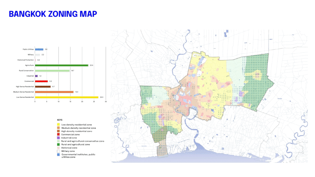
To understand Bangkok’s flood dynamics, it’s essential to look at its zoning. This Bangkok zoning map shows the urban pattern starting from the river, spreading into commercial, residential, agricultural, and conservation areas. And the flood pattern map highlights Bangkok’s defenses—flood dykes in the north, flood gates, and controlled agriculture zones in the east and south. However, areas below sea level act as floodways. Increasing rainfall, land subsidence at 1-2 cm/year, and sea level rise at 4 mm/year indicate that existing flood defenses are insufficient.


Historically, Bangkok relied heavily on man-made infrastructure—flood walls, gates, and drainage systems. While partially effective, they fail under climate uncertainty. The 2011 flood prompted Bangkok’s administration to explore Nature-Based Solutions (NBS). Initiatives like constructed wetlands have begun, but a clear, integrated solution is still lacking. Looking globally, other major coastal cities are implementing NBS to build resilience. These solutions not only address flooding but also support biodiversity and improve urban livability. For example:
- Cloudburst Concretization Masterplan, Denmark: Integrates blue-green infrastructure into flood mitigation strategies.
- Wuhan Yangtze Riverfront Park, China: Focuses on creating microenvironments along the riverside to manage flooding and enhance ecosystems.
- BIG U, USA: Incorporates flood resilience into public spaces, ensuring multifunctional benefits during dry seasons.
These examples highlight the potential of NBS as holistic solutions that go beyond flood management to promote sustainable urban living.
RESEARCH PROBLEM
” While it has long been known that natural ecosystems can play a significant role in mitigating the risk of flooding, few tools exist to quantify these protective benefits “
The Flood Resilience Toolbox aims to provide data-driven solutions to achieve flood resilience in coastal cities through adaptive urban design.
RESEARCH STATEMENT
” Flood Resilience Toolbox is a system designed to enable designers to visualize and optimize adaptive urban design strategies while assessing their hydrological and ecological impacts, leveraging AI powered nature-Based Solutions (NBS) “
The vision of this research is to serve as a pilot database, framework, and strategy for other high flood-risk or downstream locations.

With the complexity of the context and the flooding issue, The toolbox integrates AI into three components:
1. Data Classification and Analysis
2. Flood Prediction Modeling
3. Iteration for Optimal Solutions
In this term, I have successfully completed the first two steps of this research: data input and data analysis.

FLOOD RISK MAP
The first part, For Flood Risk Calculation, I combined:
- Exposure: Population, green spaces, and elevation
- Hydrological Data: Flood prediction, Flood hazard and rainfall intensity
Using a Multi-Criteria Analysis (MCA) weighted approach.

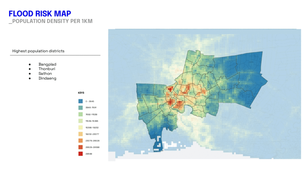
City data reveals population density concentrated along both sides of the river, gradually spreading outward. The land cover map shows that 49% of Bangkok consists of built-up areas, followed by croplands and tree cover. This highlights property vulnerability in less populated yet highly developed areas.

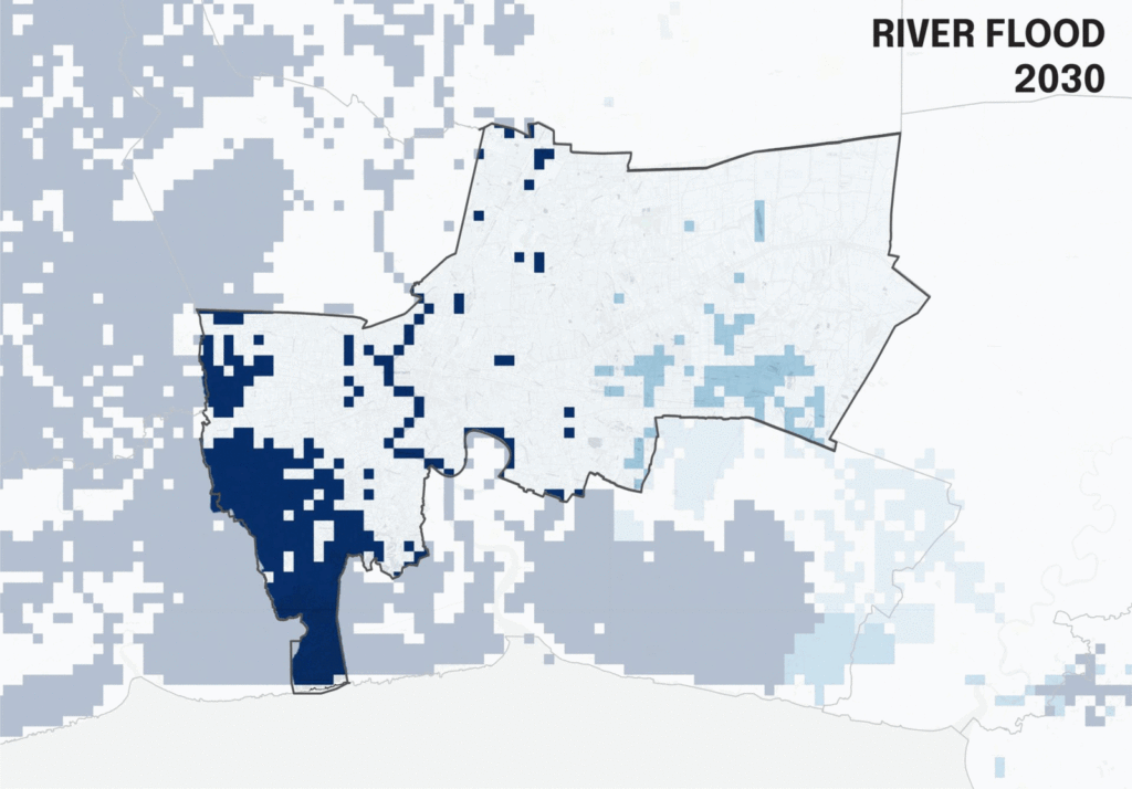
For flood projections, I used World Resources Institute data under RCP 8.5 (worst-case scenario). From the slide, From 2030- 2080, high-risk flood zones will expand toward the city center, with flood depths reaching 1.3 meters. Similarly, the coastal flood map predicts maximum flood heights of 3.0 meters in vulnerable areas.

On the ecology side, this overlay combines habitats, parks, and biodiversity significance, showing critical areas for mammals, birds, and amphibians in southern and western zones.

The notable aspect of this overlay analysis is the variation in flood risk distribution across different areas:
- East Side: Exhibits a high concentration of man-made green spaces and a dense population, indicating that flood risk primarily impacts humans in this region.
- West Side: Features a higher concentration of biological elements.
- The areas near the river face significant flood risks affecting both human and non-human populations.
- Other parts of the west primarily experience flood risks impacting non-human ecosystems.
These insights provide valuable guidance for the next stage, enabling the identification of target areas and the appropriate ecosystem services needed for effective interventions.

The resulting Flood Risk Map above identifies the highest-risk zones near the Chao Phraya River and the eastern side of the city.
To identify NBS potential, I focused on:
- Agricultural and underutilized land types.
- Open spaces with low green coverage ( < 0.5)
POTENTIAL AREA MAP

The Potential Area Map highlights opportunities for NBS, primarily in southern and eastern Bangkok.

Following the initial analysis, we now have the primary maps prepared for the next stage, which involves classifying targets exposed to flooding.

Once the high-risk map is developed, we will identify targets based on human and non-human benefits. This analysis will help determine the appropriate Nature-Based Solutions (NBS) to deliver the right ecosystem services tailored to each area. For instance:
- For human-focused target areas: NBS can provide flood regulation and cultural services.
- For non-human-focused target areas: NBS can offer services such as pollination or habitat provision, enhancing the ecological balance.

Finally, this is the envisioned Flood Resilience Toolbox:
- Integrated data collection and analysis tools
- Targeted NBS solutions based on flood risk and area potential
- Flood impact predictions to guide decision-making


