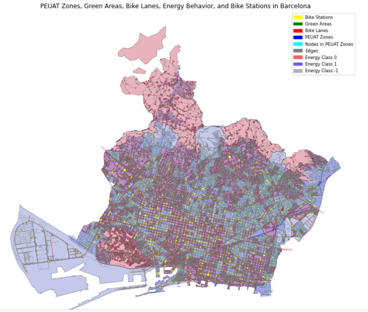
Dataset Our database contains more than 181,000 rows, each with comprehensive information. The primary database includes 17 variables, though not all are necessary for our analysis. The most crucial data points are location (latitude and longitude), type of food establishment, type of inspection, inspection results, and risk level. As the person who uploaded the database … Read more
Fields at Play
Fields at Play identifies the value of gender inequality in Olympic infrastructure and proposes to leverage the derived $12.6B Olympic gender gap in sports facilities to fund the revitalization and ongoing program of reliable, safe, and comfortable spaces for women at risk of gender-based violence. Understanding the purpose and outcomes of Olympic infrastructure strategies in … Read more
Kyoto Blossoms & Tourism Machine Learning
Project Focus For our Graph Machine Learning project, wanted to look at the city of Kyoto and Tourism Behavior around Cherry blossom patterns. Specifically, we set out to find out how cherry blossom patterns might affect the behavior and walking paths of tourists within the city. Data Sets We started by collecting our data sets … Read more
Riverine Alliances
The intensification of human activities has transformed river basins, characterized by the loss of natural floodplains, an increase in impermeable surfaces, and the escalation of surface runoff. This thesis explores the importance of tailoring flood prevention strategies to upstream conditions to aid in flood risk management for downstream urban areas. Specifically, it presents an incentive-based, … Read more
Predict Yelp Ratings based on Urban Data using GML
Hypothesis The goal of this research was to investigate if open spatial data could predict Yelp ratings utilizing graph machine learning (GML) methods. We hypothesize that urban phenomena, events, and objects will indicate customer reviews and popularity, and therefore, could be used predict ratings. In particular, we perform edge classification using the DGL library. For … Read more
Balancing Tourists and Residents in Barcelona
To predict whether a location in Barcelona is a key tourist site or not using graph data and specific contextual features, including the impact of the PEUAT plan on regulating tourist accommodations. The features explored and the URL selected on the Barcelona open data are score or indicator related to the tourism plan PEUAT, Proportion … Read more
Metro Station Prediction in Stockholm
This post describes the development of a method to predict metro station locations using Graph Neural Networks (GNNs). Our journey began with a challenge familiar to urban planners: how to strategically place new metro stations to optimize transportation networks. In this case the city of Stockholm was used as testbed. The Challenge of Data Imbalance: … Read more
100-Year Flood Risk Road Intersection Classification
Beginnings Our project’s concept is to develop a classification model that identifies street intersections (graph nodes) in Stockholm, Sweden, susceptible to flooding during a 100-year flood event. Based on our initial research, we found that graph machine learning operates at three levels: the graph, its edges, and its nodes. With access to a 100-year flood … Read more
Tiny Topographies
Optimizing Bar Buildings for Sunlight and Pathways The aim of this project was to design a typology of housing is needed that resembles small, artificial terrains. The Bar Building typology will have set of long, dense buildings that will mimic the form of a topography. The forms will need to be optimized to allow for all the … Read more
Forms of Inadequacy in Dakar
Abstract Dakar is Senegal’s capital city and rapidly urbanizing economic center. Today, Dakar’s urban area is home to 3.54M people, half of Senegal’s population, and generates 55% of the Country’s GDP. This growth is artificially constrained by an urban growth boundary, where new homes are informally built, and due to the city’s topography, a peninsula … Read more
Rising Waters
The year is 2100. Latin America is sinking. Due to global warming the polar icecaps have almost melted completely. In addition the increased temperature has caused the global water mass to expand by almost 1%. As a consequence sea levels are rising at unprecedented levels globally. The coastline in South America is hard-hit by these … Read more
Investigating Tribal Right in India: Its need and its challenges
1. Abstract India is a country known for its diversity. In the diverse fabric of inhabitants, India’s governing policies and laws are meant to safeguard the rights and responsibilities of minor groups residing in India, amidst the general laws for all of her inhabitants. Minor groups like tribes of India, registered in the schedule of … Read more
Drop by Drop – Simulate erosion
Introduction Fascinated by the formation of landscapes through geological processes, I wanted to develop an interactive tool that simulates the effects of erosion on a virtual terrain. The goal was to both illustrate how erosion works and to create an experimental playground for designing one’s own landscape forms. The development utilized VUE, ThreeJS, and Rhino.Compute. … Read more
Tracking Cross-Border Monetary Flows to measure Geopolitical Insecurity
Creating a streamlined pipeline to visualize and extrapolate financial data enabling a correlation with spatial geo-specific information. The World and all countries alike have been increasingly more susceptible to events and developments in the geo-political theatre. It is not surprising that the world’s top two economic and military superpowers play a pivotal role in this … Read more