AQUA.NEST: An AI-Powered Decision Support Toolbox for Adaptive Urban Design Using Nature-Based Solutions in Flood-Exposed Coastal Cities
Coastal urban flooding is emerging as one of the most urgent climate challenges of our time. Without strong adaptation, annual flood damages could reach €930 billion globally by 2050, even with improved infrastructure (OECD, 2020). Rising sea levels and expanding coastal populations mean more people face regular flood exposure. This is not just about addressing today’s risks, it’s about preparing for a future where flooding becomes a persistent and costly threat.
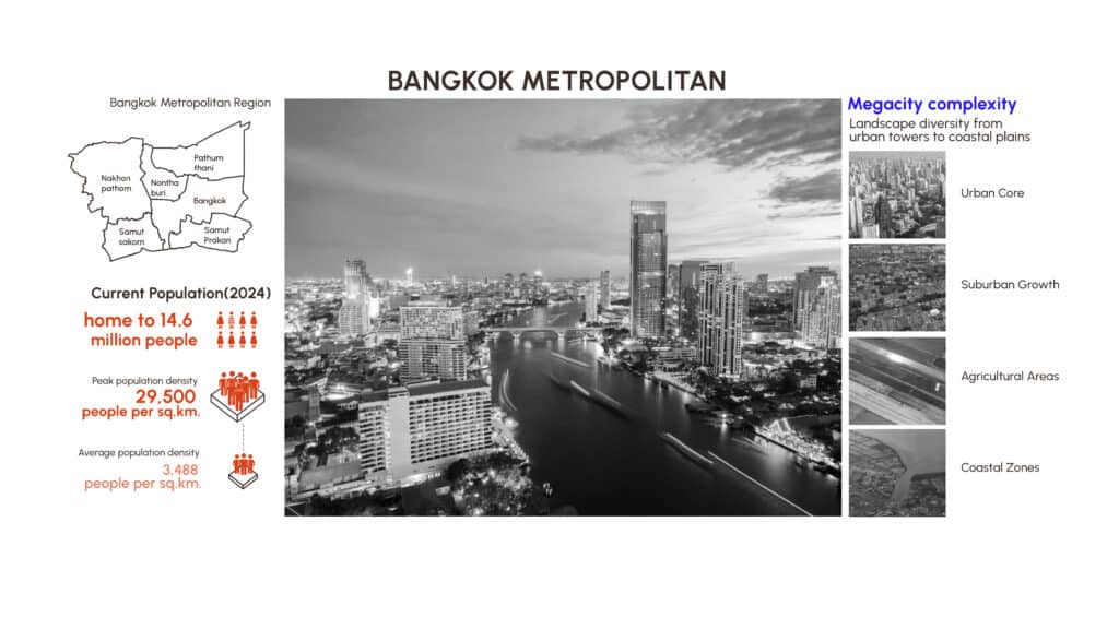
Southeast Asia stands at the epicenter of this crisis. With nearly 700 million residents and rapid urbanization, the region’s major cities like Jakarta, Manila, and Bangkok face severe and frequent floods. Bangkok, in particular, is an alarming case. By 2050, up to 20 million people may live in its metropolitan region, where land subsidence and sea-level rise compound flood risks. The city’s location in the Chao Phraya River Basin, coupled with low elevation and intense rainfall, makes it one of the most vulnerable urban areas in the world.
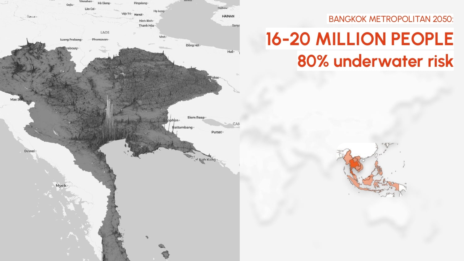
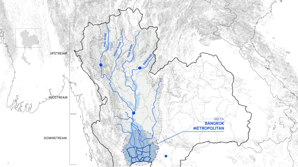
Bangkok sits at the heart of the Chao Phraya River Basin, Thailand’s largest watershed. As a downstream collection point, it receives water from four major rivers converging into the city. However, its low elevation, barely above sea level, and prolonged rainy seasons lasting 4 to 6 months make it exceptionally vulnerable to multiple flood types including runoff, river, and coastal floods. The Bangkok Metropolitan Region comprises six provinces, where agricultural and industrial zones sit dangerously close to flood-prone urban areas. The deadly combination of land subsidence, rising sea levels, and rapid urbanization has placed Bangkok among the world’s most at-risk cities.
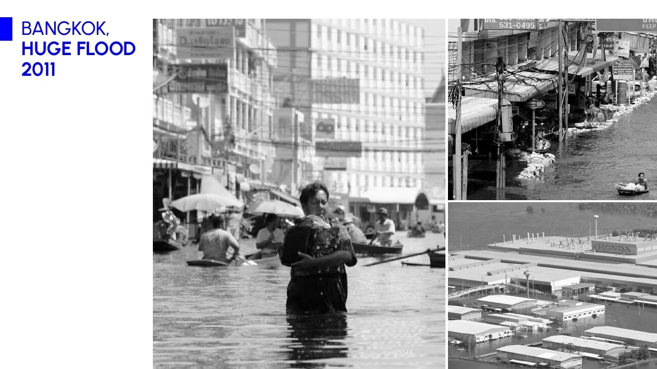
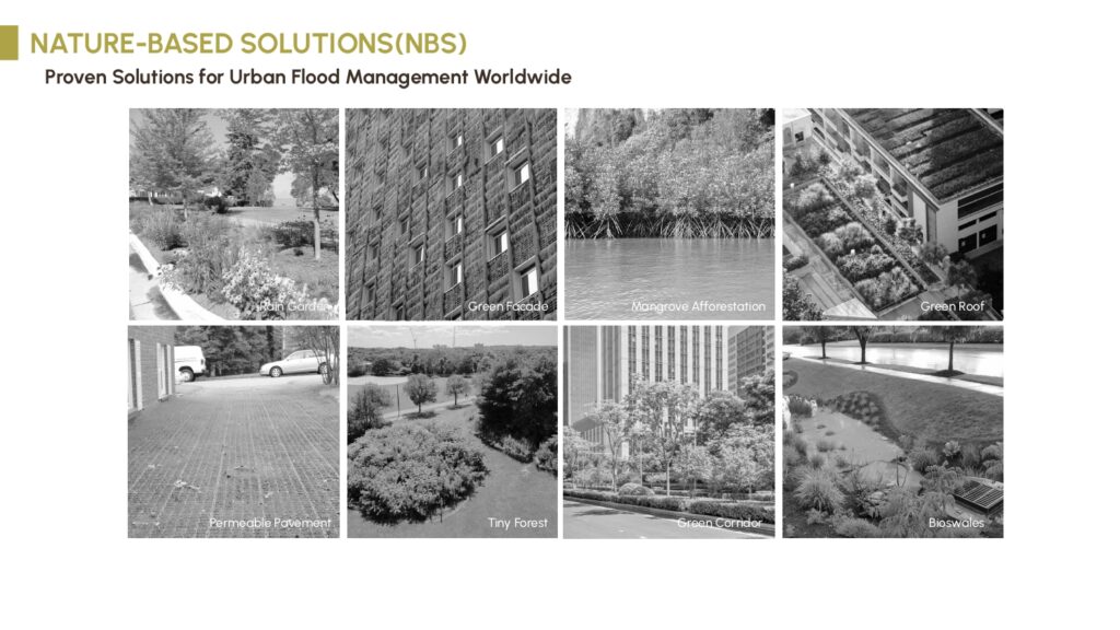
Traditional flood defenses are no longer enough. Bangkok’s reliance on dikes and drainage systems has proven insufficient, as shown during the devastating 2011 floods. Urban growth has outpaced nature’s ability to absorb water. In response, cities worldwide are adopting Nature-Based Solutions (NBS), such as rain gardens, permeable paving, and urban forests that not only mitigate floods but also enhance biodiversity and climate resilience. These global efforts highlight the urgent need for adaptive, nature-integrated strategies in cities like Bangkok.
RESEARCH PROBLEM
“Despite these proven benefits, we face a critical implementation gap. No standardized tools exist to quantify the effectiveness of NBS in urban planning, making it difficult for cities to make informed decisions about where and how to invest in nature-based infrastructure. This brings us to the heart of my research, which is to develop a system that bridges this gap. Let me introduce you to AQUA.NEST.”
What is AQUA.NEST?
“AQUA.NEST represents a paradigm shift in urban flood management. It’s an AI-powered decision support system designed to empower designers, planners, and decision-makers to visualize and optimize adaptive urban design strategies while accurately assessing their hydrological and ecological impacts. By leveraging artificial intelligence to analyze Nature-Based Solutions, AQUA.NEST transforms complex environmental data into actionable insights for building flood-resilient cities.“
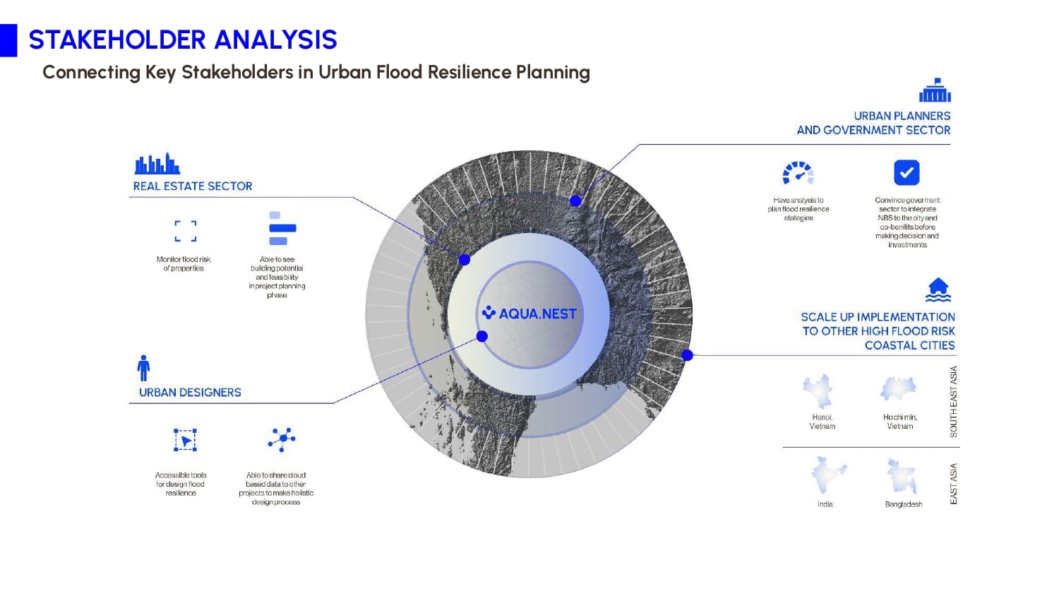
AQUA.NEST is an advanced decision support toolbox designed to guide climate-resilient urban planning using Nature-Based Solutions (NBS). Developed with an AI-powered engine, the platform supports urban designers, planners, and decision-makers with data-driven tools to address flooding in coastal cities. From Bangkok to Ho Chi Minh City, AQUA.NEST aims to foster a global network of cities that can adapt to flood risks through intelligent, sustainable strategies.
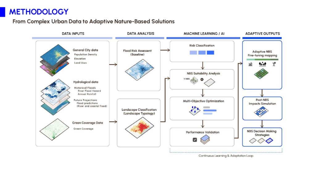
The system is built around four integrated modules: data integration and environmental assessment, AI-based simulation and impact modeling, optimized NBS scenario generation, and a visual decision support interface. This modular structure allows users to assess citywide flood risks, simulate environmental impacts, and develop customized urban strategies with real-time feedback. It brings scientific modeling into the hands of practitioners in an accessible and actionable format.
Methodology
This research uses a data-driven approach with four main phases. First, it collects and processes city, hydrological, and green coverage data. Second, it conducts a flood risk assessment and classifies landscapes using land use and population data. Third, it applies machine learning to identify the best NBS options and builds an allocation and impact prediction model using multi-objective optimization. Finally, it develops an interactive tool to support real-world decision making.
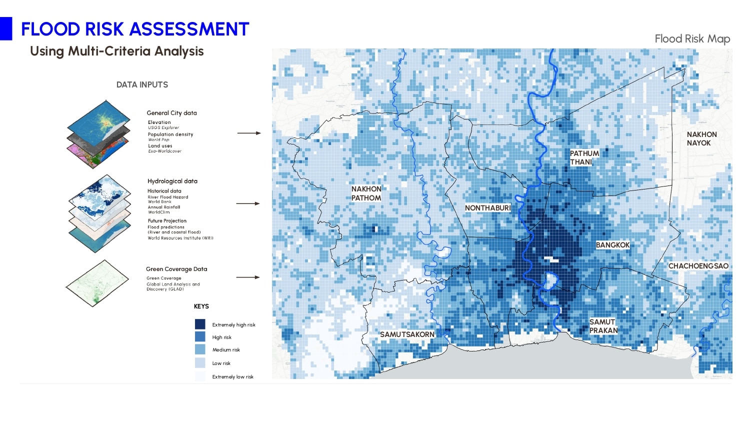
I. Flood Risk Assessment
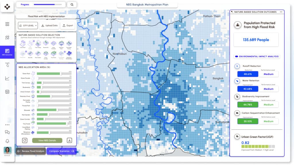
The flood risk assessment process integrates multiple data inputs. It combined hydrological data, including both historical flood records and future flood projections, with comprehensive city and green coverage data. Using multi-criteria analysis, it generated this flood risk map that reveals high-risk areas concentrated in central Bangkok and extending northward. This baseline assessment provides the foundation for all subsequent NBS planning process
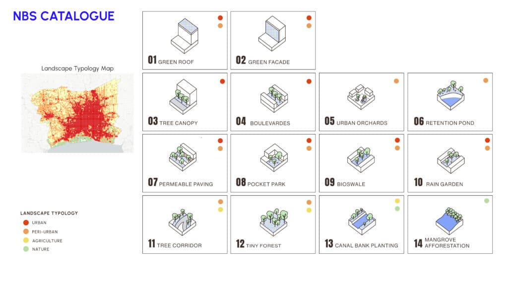
NBS Catalog
Building on the flood risk assessment, this research developed a targeted catalog of nature-based solutions for flood mitigation and adaptation. These solutions are selected and adapted from the GreenInCities EU project, ensuring alignment with international best practices.
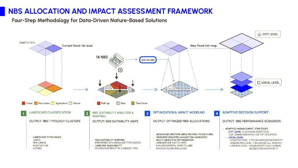
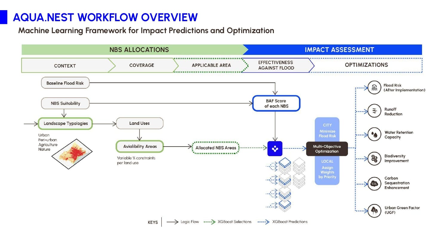
With the flood assessment and NBS catalog in place, the next challenge was how to match each solution to the right location in a complex urban landscape. To address this, a four-step machine learning framework was created to guide NBS allocation and impact assessment.
II. NBS ALLOCATION AND IMPACT ASSESSMENT FRAMEWORK
This framework consisted of 4 steps for finding NBS allocation and impact assessment.
- Landscape Classification was conducted to generate NBS typology clusters.
- Suitability Analysis was performed to refine the NBS catalog and produce a suitability map.
- Optimization & Impact Modeling was applied to target multiple objectives, including flood risk reduction and environmental performance.
- Adaptive Decision Support were developed NBS performance scenarios to support decision-makers with clear NBS performance pathways for different areas.
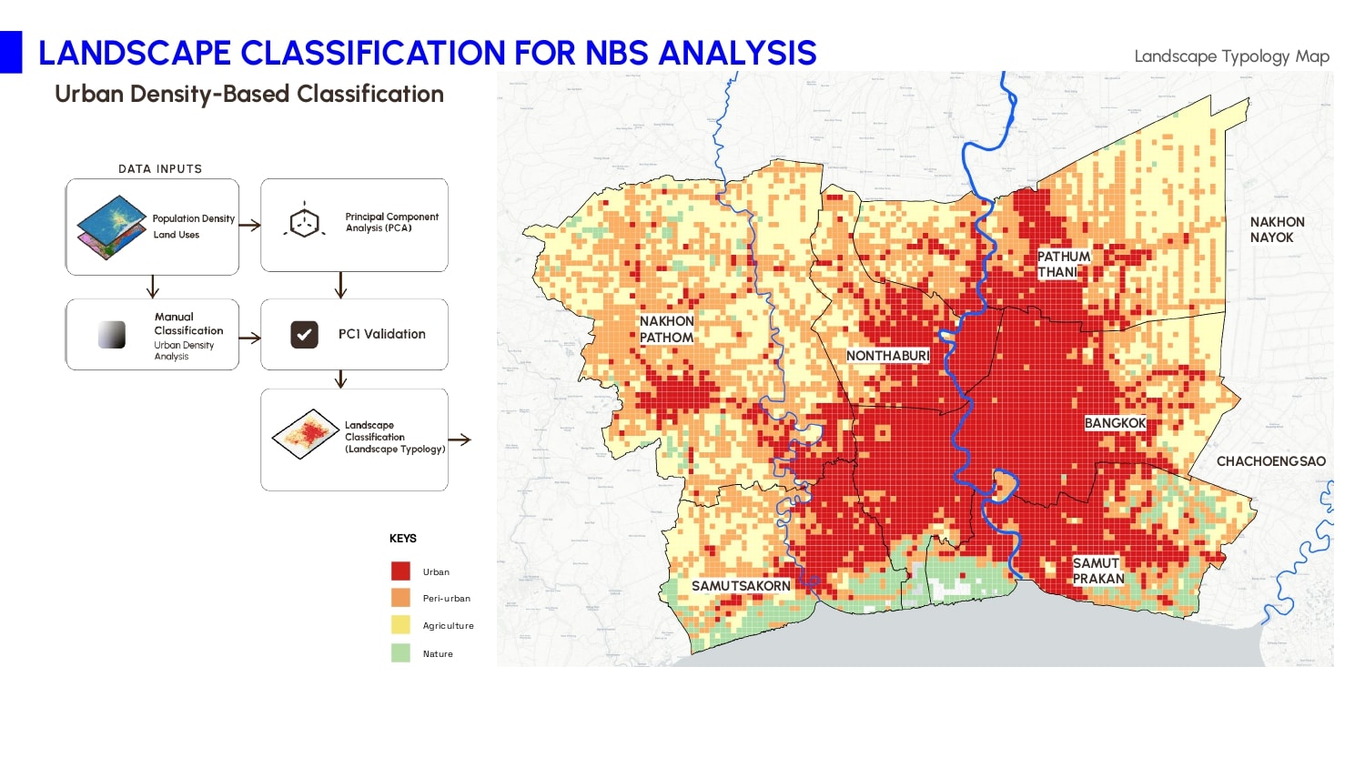
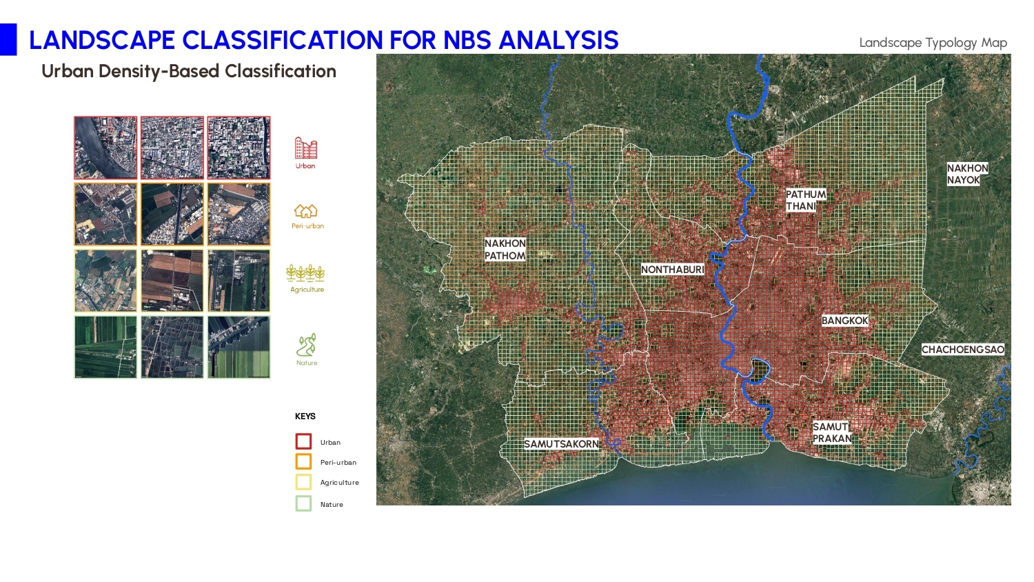
1. Landscape Classification It was conducted to generate NBS typology clusters.
The research divided Bangkok into 1-kilometer grids and classified each area based on population density and land use. This method was validated using Principal Component Analysis, which showed strong alignment with manual classification. The result confirmed that this approach effectively captures spatial variations and is both scientifically reliable and practical.
Satellite imagery further illustrated four key landscape typologies. Urban zones form the dense core around the Chao Phraya River, while peri-urban areas spread toward the city’s edge. Agricultural lands dominate the northern region, and natural areas appear near reservoirs and the Gulf of Thailand. Understanding these patterns was essential for guiding the next stage of Nature-Based Solution planning.
2. NBS Suitability Analysis and Mapping
After clustering NBS options with their suitable typologies, this refined catalog enables detailed analysis of each NBS’s potential area and impact. It provides the guidelines needed for precise planning and implementation.
Each zone supports different NBS strategies. Urban cores benefit from compact solutions like green roofs and pocket parks, while peri-urban districts allow for larger-scale projects such as retention ponds and tiny forests. Agricultural areas integrate NBS with ongoing land use, using canal planting and tree corridors. Natural zones, especially near coastlines, gain resilience through mangrove restoration and protective planting. These tailored interventions ensure that environmental performance and flood mitigation are maximized in every setting.
3. Optimization & Impact Modeling
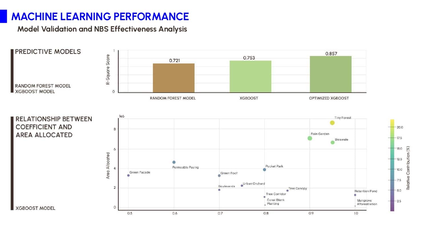
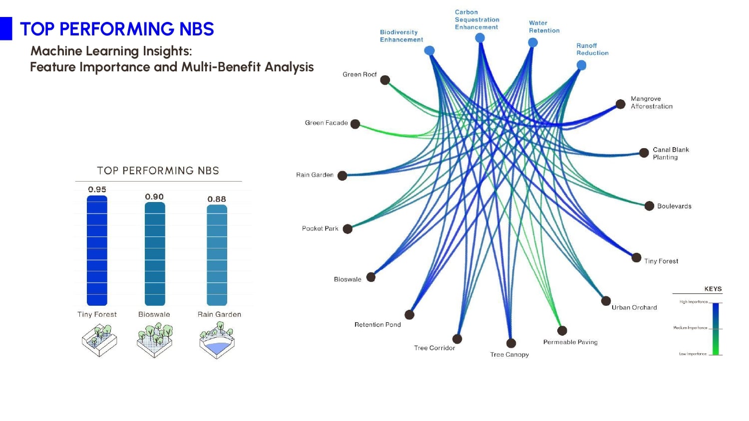
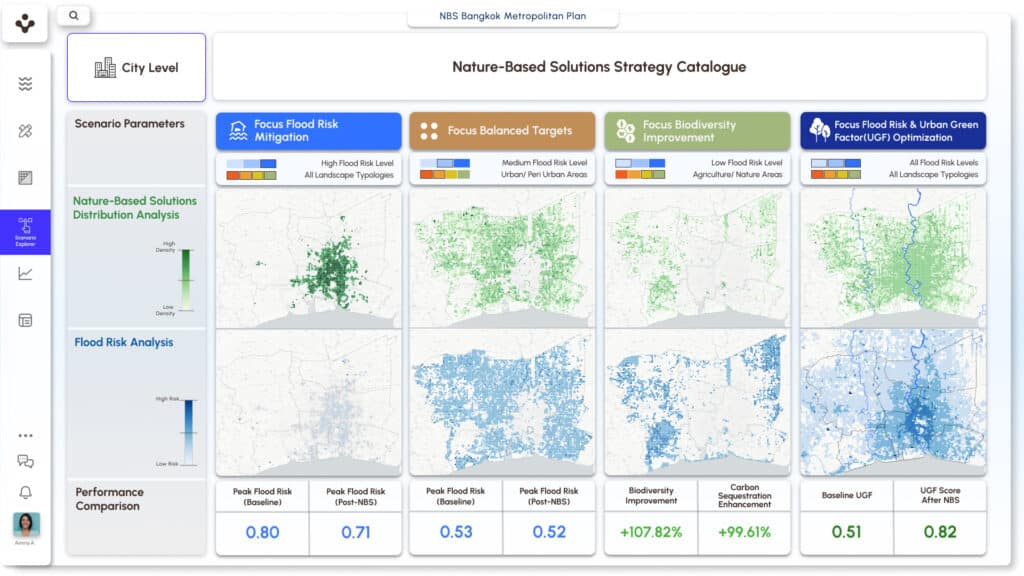
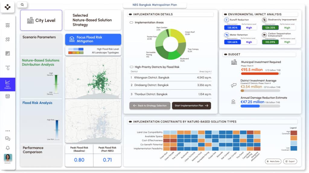
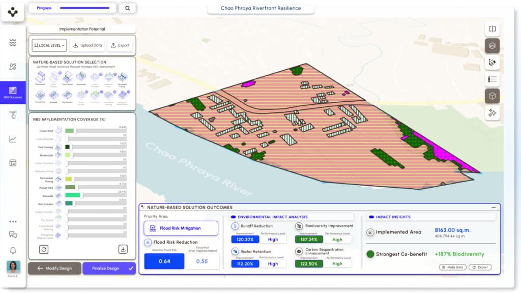
The heart of AQUA.NEST lies in its optimization engine as shown in the diagram below. Using predictive models and multi-objective algorithms, the platform determines ideal locations and area requirements for each NBS. Key metrics such as runoff reduction, water retention, biodiversity value, and carbon sequestration are calculated using Biotope Area Factors. These values are visualized in an interactive interface that enables users to explore various design options, refine plans, and see projected outcomes instantly.
Among the tested models, XGBoost delivered the highest performance, with an R² of 0.857 in predicting flood risk reduction. The system highlighted Tiny Forests, Rain Gardens, and Bioswales as the most impactful solutions across scenarios. These insights offer practical guidance for policy and investment, ensuring limited resources are directed toward the most effective strategies.
4. Adaptive Decision Support
The NBS performance scenarios are essential for adaptive urban resilience because, in flood management, there is no one-size-fits-all solution. AQUA.NEST offers a systematic yet flexible approach with context-aware decision-making that adapts to different user profiles and local conditions. The optimization system operates on two levels. City-wide optimization serves urban planners who need comprehensive overviews, while local optimization serves urban designers who require detailed scenarios for specific areas. High-risk areas prioritize flood mitigation, medium-risk areas can balance multiple benefits, and low-risk areas can focus on enhancing biodiversity and long-term resilience.
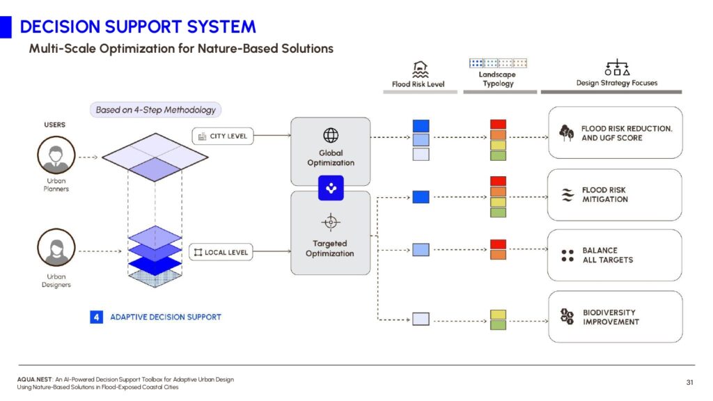
III. Model to Interface, AQUA.NEST Platform
AQUA.NEST’s final component is its adaptive design interface, which transforms complex data into context-specific plans. Users can explore both city-level and local-level strategies, fine-tune implementation areas, and receive recommendations based on real-time landscape assessments. The platform encourages flexible, knowledge-informed planning that adapts to evolving urban and climate conditions, which is turning data into decisions and concepts into actionable resilience.
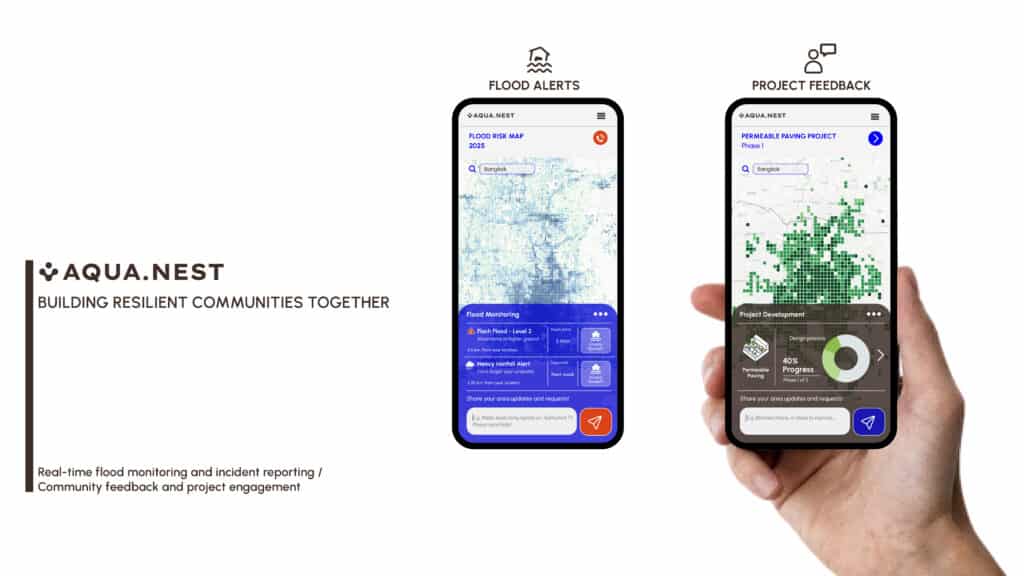
AQUA.NEST supports not only industry professionals but also empowers communities to take part in flood resilience. Its vision includes two key features: real-time flood alerts that turn technical forecasts into actionable information for residents, and a platform for community input during urban resilience projects. This encourages feedback, shared decision-making, and lasting engagement to ensure projects meet local needs.
IV. Future Vision, Create Intelligent NBS Ecosystem
Continuous Learning and Adaptation After establishing this foundational system, AQUA.NEST‘s true potential emerges through continuous learning and adaptation. The next phase begins when users submit implementation data and the system receives real performance monitoring feedback. This creates a dynamic learning environment where AQUA.NEST continuously adapts solutions and adjusts recommendations based on actual outcomes. The system will learn why certain solutions underperform and why users select alternatives to system suggestions.

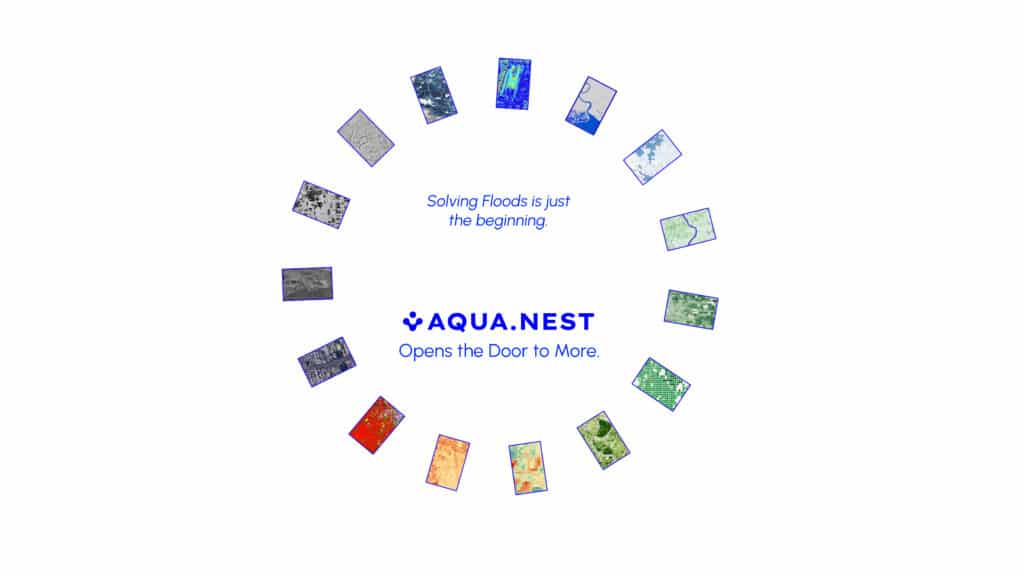
Solving flooding is only the beginning of what AQUA.NEST can achieve. This research envisions a future where cities not only withstand climate challenges but thrive by working in harmony with nature. By combining advanced AI with nature-based solutions, we are building not just flood defenses, but healthier, more sustainable, and resilient urban environments for millions.