The MaCAD is a unique online programme training a new generation of architects, engineers and designers ready to develop skills into the latest softwares, computational tools, BIM technologies and AI towards innovation for the Architecture, Engineering and Construction (AEC) industry.

GRAPH MACHINE LEARNING TOWARDS ADAPTIVE CITIES: A data-driven approach to sea level rise problematics

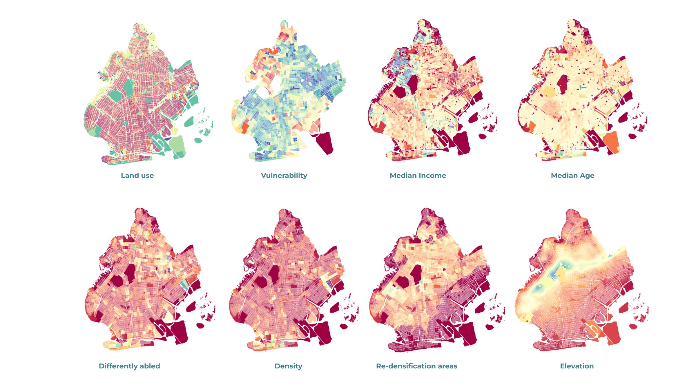
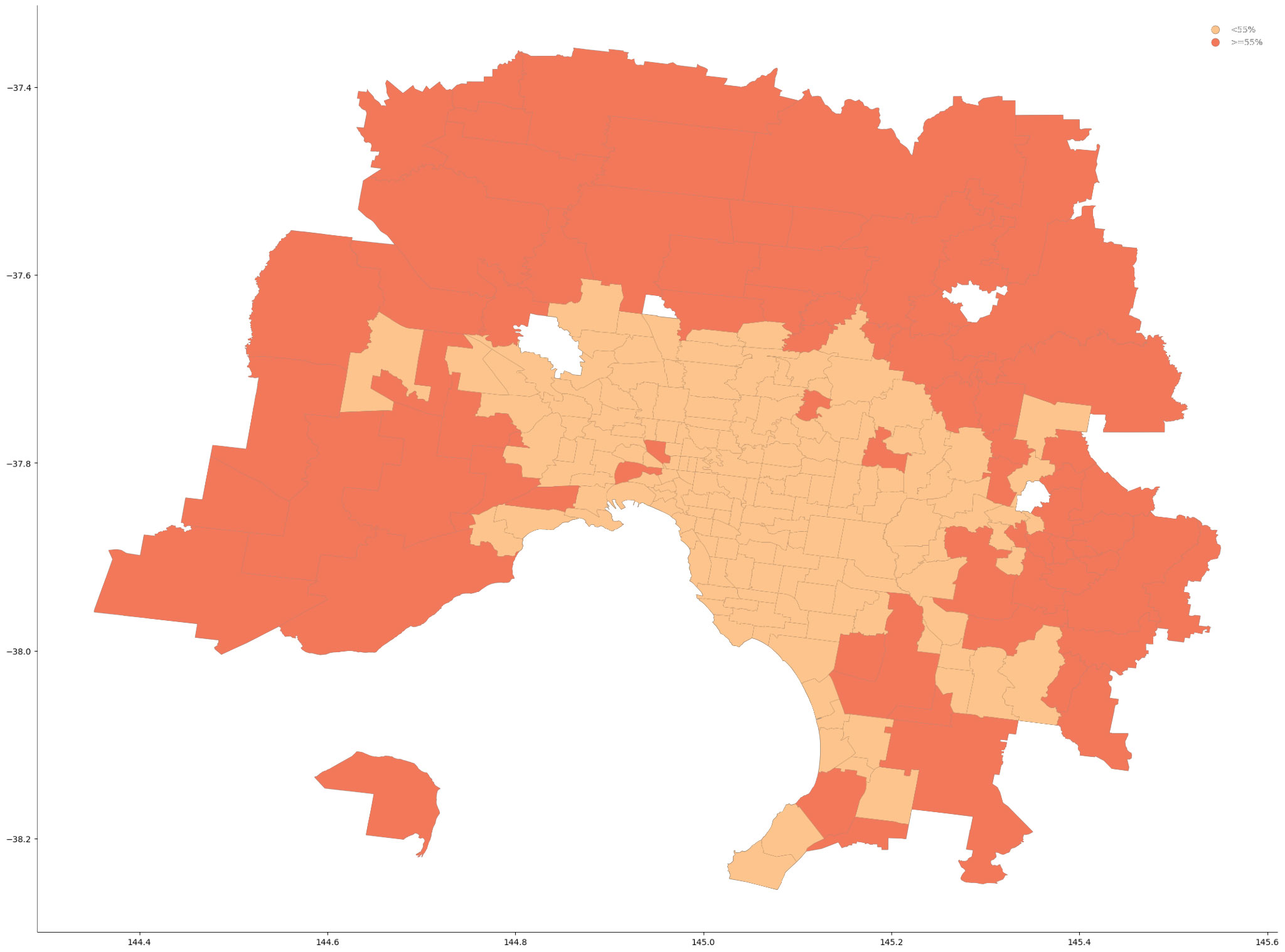
Abstract This thesis explores experimental approaches when addressing sea level rise challenges , the impacts of land loss due to sea rise and population growth. It delves into considerations associated with innovative approaches while emphasizing the integration of urban syntax and graph machine learning. Drawing upon case studies and open data, underscoring the importance of … Read more

Superblock BCN

A Multidimensional Study of the Superilla My research starts from observing human behaviour. Often when we face a change in our lives, especially when it wasn’t planned, we feel resistance and it takes time before we accept and embrace it.  As you probably know Barcelona in the last few years lived some changes in its … Read more

FireFly

Harnessing the power of drone-based photogrammetry and artificial intelligence to create a low-cost urban wildfire diagnostic tool. In recent years, the global community has witnessed a significant upsurge in the frequency and intensity of wildfires. Driven by a combination of climate change, urban expansion, and land-use practices, these fires have not only devastated vast natural … Read more

Wildlife Corridors

Our project focuses on modeling and predicting habitat fragmentation avoidance mechanisms using graphs. We investigate wildlife corridors in Australia, leveraging graph-based approaches to create coherent passages and connect forest areas. By analyzing satellite images, road data, and other metrics, we construct and evaluate graph models that incorporate forest containment, node characteristics, and connectivity. Our goal … Read more

Mississippi 2102

Meanders on the Lower Mississippi River In the battle between architecture and nature, nature tends to win. Therefore, it is important that we understand how rivers move over time so that we can know the best and the worst places to build. Our project studies the Lower Mississippi River from Cairo, Illinois to New Orleans, … Read more

Compath

Problem statement and project objectives How can we create a routing system that orients onto its users environment, utilizing open source data? How do we collect and process data? Our objective is to utilize the existing data and generate any missing data required for each aspect of our analysis.  We combine data from different sources … Read more

A Reflection on Tools for Environmental Analysis

The aim of this blogpost is to summarize the tasks and tools practiced during the course of the S1 Seminar: Digital Tools for Environmental Analysis and reflect on the overall learnings, advantages and disadvantages of each. During the course of the semester, I have explore tools for analysis and optimization of elements related to sun, … Read more

Nested Flocks

What if our design follows the trails of flocks? The #flockingbehaviour guides the circulation paths nested inside the environmentally responsive shell. An investigation of #optimization with #grasshopper#houdini#culebragh#biomorpher and render with #unrealengine.

Peaceful parasites

Historical data Peaceful parasites is based in Belfast, Northern Ireland and addresses the urban scars created by the recent troubles. Deep rooted segregation has generated detrimental urban divides and this project aims to solve this problem. Historically, the troubles started in 1969 and subsides to some degree in 1998 with the ¨good friday agreement¨. 2023 … Read more