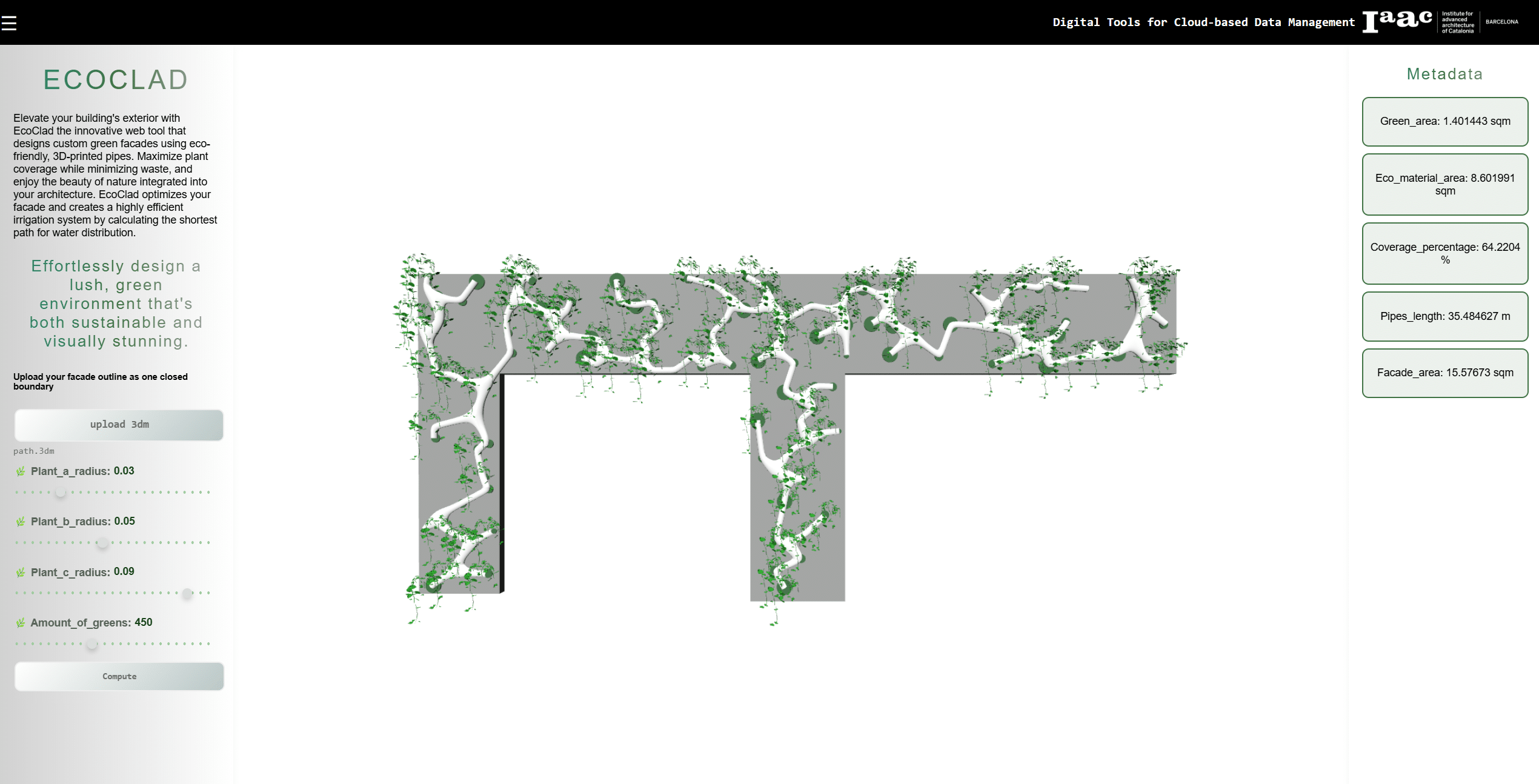
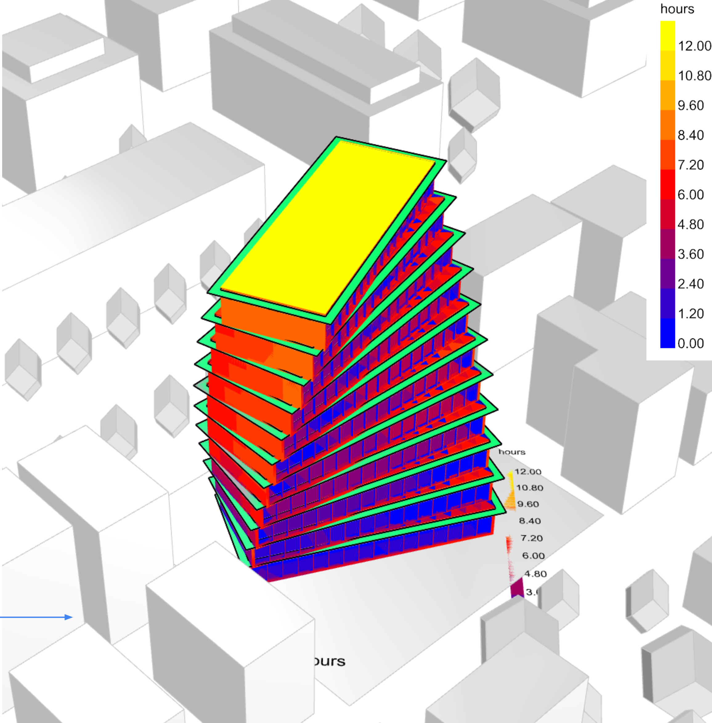
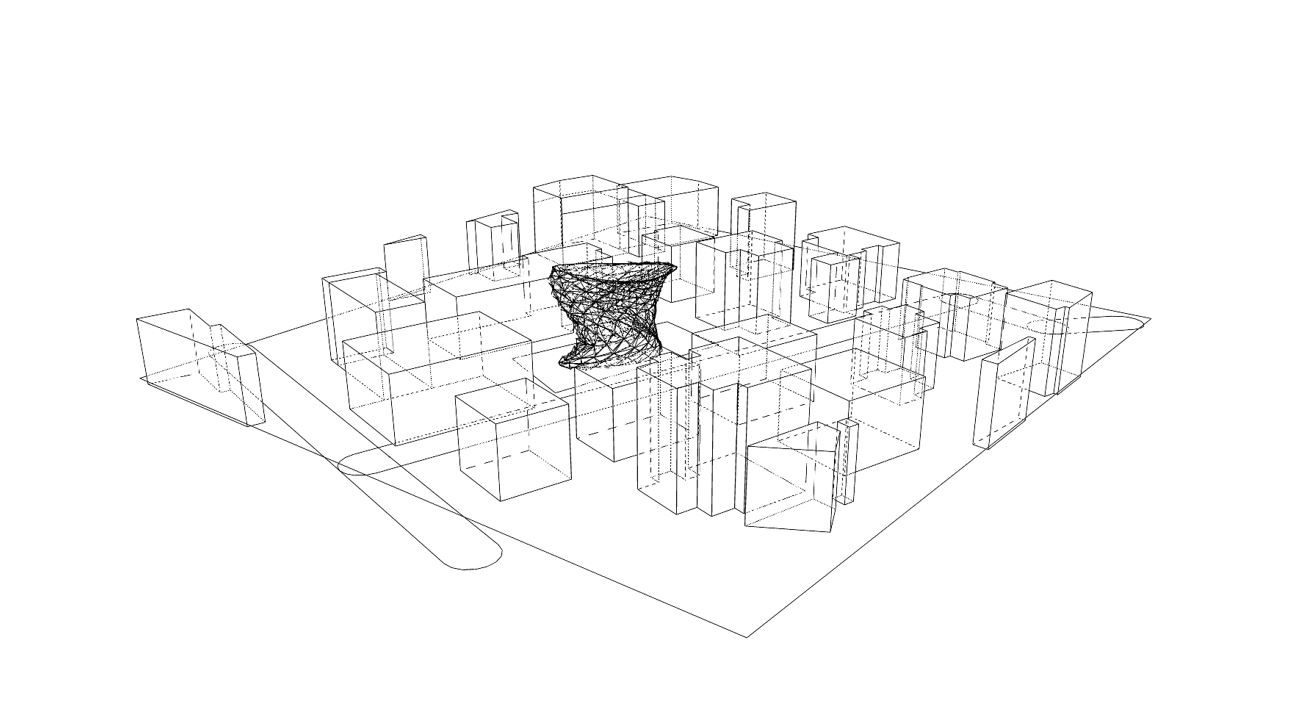
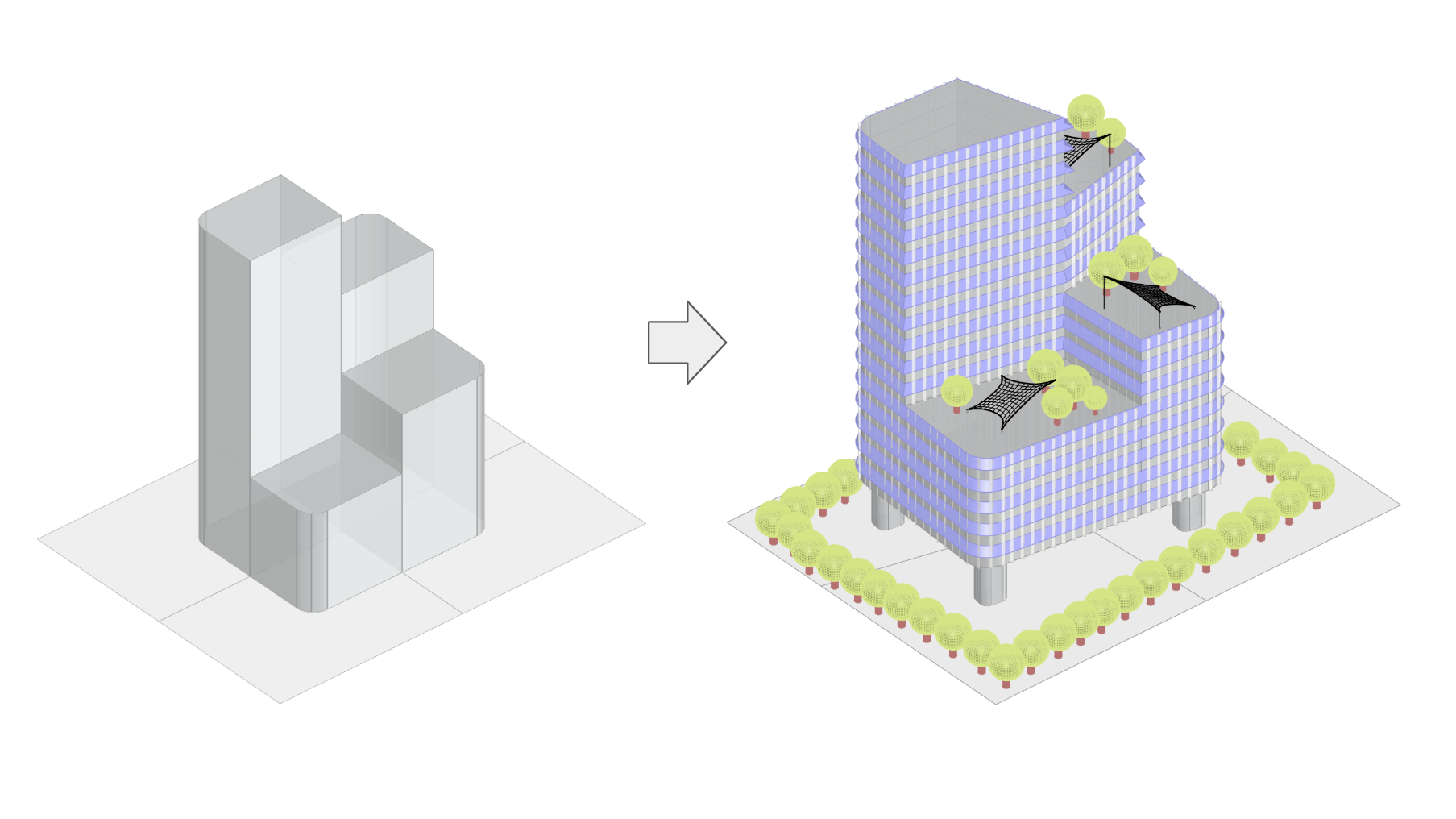
The MaCAD is a unique online programme training a new generation of architects, engineers and designers ready to develop skills into the latest softwares, computational tools, BIM technologies and AI towards innovation for the Architecture, Engineering and Construction (AEC) industry.

Filters

Digital Tools for Environmental Analysis | Rome

Rome has a Mediterranean climate characterized by hot, dry summers and mild, wet winters. Average temperatures range from around 8.5°C in winter to about 31°C in summer​. The city experiences moderate rainfall, with the wettest months typically being October and November. Climate Analysis In Rome, the bulb temperature, which reflects the combined effect of air … Read more

Environmental Analysis – Austin, Texas

Austin has a humid subtropical climate (Köppen climate classification: Cfa), characterized by hot summers and mild winters.  The city experiences long, hot summers and short, mild winters, with brief transitions in spring and fall. The climate data used in this analysis was obtained from: – Location: Austin-Mueller Municipal Airport, Texas, USA – Weather Station ID: 722540 … Read more

Environmental Analysis of Madrid

Part 1: Climate Analysis Madrid falls into two koppen climate classification zones: a cold semi-arid climate (classification BSk) in the metropolitan area, and a mediterranean, dry-summer climate in the west half of the city (classification Csa). The main characteristics of this climate are hot, dry summers and cold, humid winters. There are also large temperate … Read more

Climate Sensitive Facade Intervention for Urban Heat Island Mitigation

Research Questions: Can climate sensitive facade interventions reduce the intensity of the Urban Heat Island effect within urban blocks in arid climates?“ Research Goal: The goal is to propose simplified, climate-sensitive facade interventions in highly urbanized cities that reduce energy loads by mitigating Urban Heat Island (UHI) effects, while complying with climate-resilient regulations. These interventions … Read more

C.O.M.F.O.R.T

City-Oriented Modeling for Observational Radiative Thermal comfort CONCEPT The idea behind C.O.M.F.O.R.T is to provide an effective tool for architects and urban planners to design cooler and more sustainable cities, leveraging the power of machine learning and AI technologies. FACTORS OF IMPACT To create COMFORT we had to study the different factors of impact which … Read more

Thermal Insight: Optimizing Indoor Analysis

Thermal Insight would be a standalone app that optimizes indoor environments by predicting thermal comfort. With simulations from trained models to help enhance occupant comfort and energy efficiency, evaluating metrics like PMV, PPD, and MRT. This tool would help improve well-being and productivity while achieving efficiency goals. Abstract Methodology Use Case Data Analysis Results and … Read more

Skin Sense

Skin Sense is a project that aims to help users optimize the thermal comfort of their interior spaces by applying skin shaders. Why implement this? What can skin sense help the user with? Once the designer designs the skin for the building facade it has to be analyzed for indoor comfort. To analyze indoor comfort … Read more

DF Predictor (cGAN)

DF Predictor aims to revolutionize daylight prediction in architectural design by implementing the conditional generative adversarial network (cGAN) Pix2Pix to predict daylight factors, motivated by the need to improve efficiency and accuracy in daylight analysis. Daylight factor analysis, an integral part of the early design stages and mandated by building codes, is typically lengthy due … Read more

Predictive Coastal Erosion

Why? Coastal erosion is a dynamic and complex process influenced by both natural factors and human activities. Natural causes such as wave action, tidal patterns, weather events, and rising sea levels due to global warming significantly contribute to the gradual wearing away of coastlines. Additionally, human interventions like coastal construction, sand mining, and deforestation exacerbate … Read more

Real-time Daylighting Performance for Adaptive Reuse Planning

This project aimed to develop a daylight predictor to facilitate and generate well-informed adaptive reuse projects, with a specific focus on providing sustainable design solutions for low-income housing. Los Angeles (LA) was selected as a case study due to its proactive open data initiatives and commitment to adaptive reuse. This proposal provides a snapshot of … Read more

Materializer

Introduction Our project, Materializer, leverages the power of multiple self-trained machine learning models to predict material quantities based on an image uploaded by the user and the building coordinates. This innovative approach utilizes image segmentation to isolate buildings, image classification to read material pixels, and a height prediction model for buildings lacking height information in … Read more

100-Year Flood Risk Road Intersection Classification

Flood Risk Classification

Beginnings Our project’s concept is to develop a classification model that identifies street intersections (graph nodes) in Stockholm, Sweden, susceptible to flooding during a 100-year flood event. Based on our initial research, we found that graph machine learning operates at three levels: the graph, its edges, and its nodes. With access to a 100-year flood … Read more

Subterranean Eden: Martian Harvest Halls

“An innovative way for agriculture on Mars, pushing boundaries of space exploration ensuring future interplanetary habitation.” Mars—the Red Planet—is getting closer. According to the experts, human settlements on Mars might be visible in ten years, allowing for more space exploration. Keeping that in mind, this semester’s goal is to create a 300-person Mars colony. The … Read more

Aquamines

Inhabiting Ice Cavities under the Martian Surface Introduction – The Idea For the first settlers on Mars, we have envisioned a colony of Aqua-Miners with the primary task of harvesting water as a resource from the ice beneath Mars’ surface, storing it and recycling it for sustainable use. Our approach to this problem has been … Read more

Drop by Drop – Simulate erosion

Introduction Fascinated by the formation of landscapes through geological processes, I wanted to develop an interactive tool that simulates the effects of erosion on a virtual terrain. The goal was to both illustrate how erosion works and to create an experimental playground for designing one’s own landscape forms. The development utilized VUE, ThreeJS, and Rhino.Compute. … Read more

DeCARB

Introducing DeCARB: An easy-to-use tool that calculates Embodied Carbon, End-of-Life Carbon, and Total Cost for any rectangular massing geometry. Quantifying emissions from material extraction to disposal can guide architects and engineers in selecting low-carbon materials and methods early in the design process. With a focus on reducing environmental impact and aligning with green building standards, … Read more