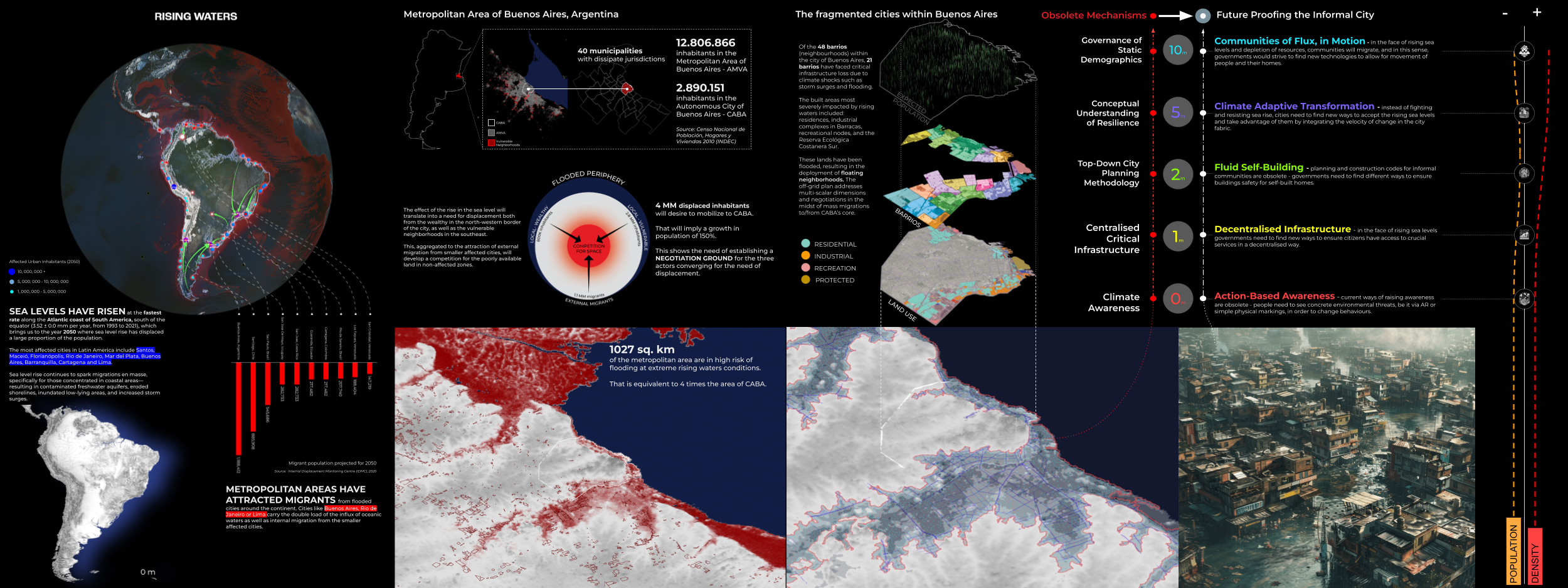
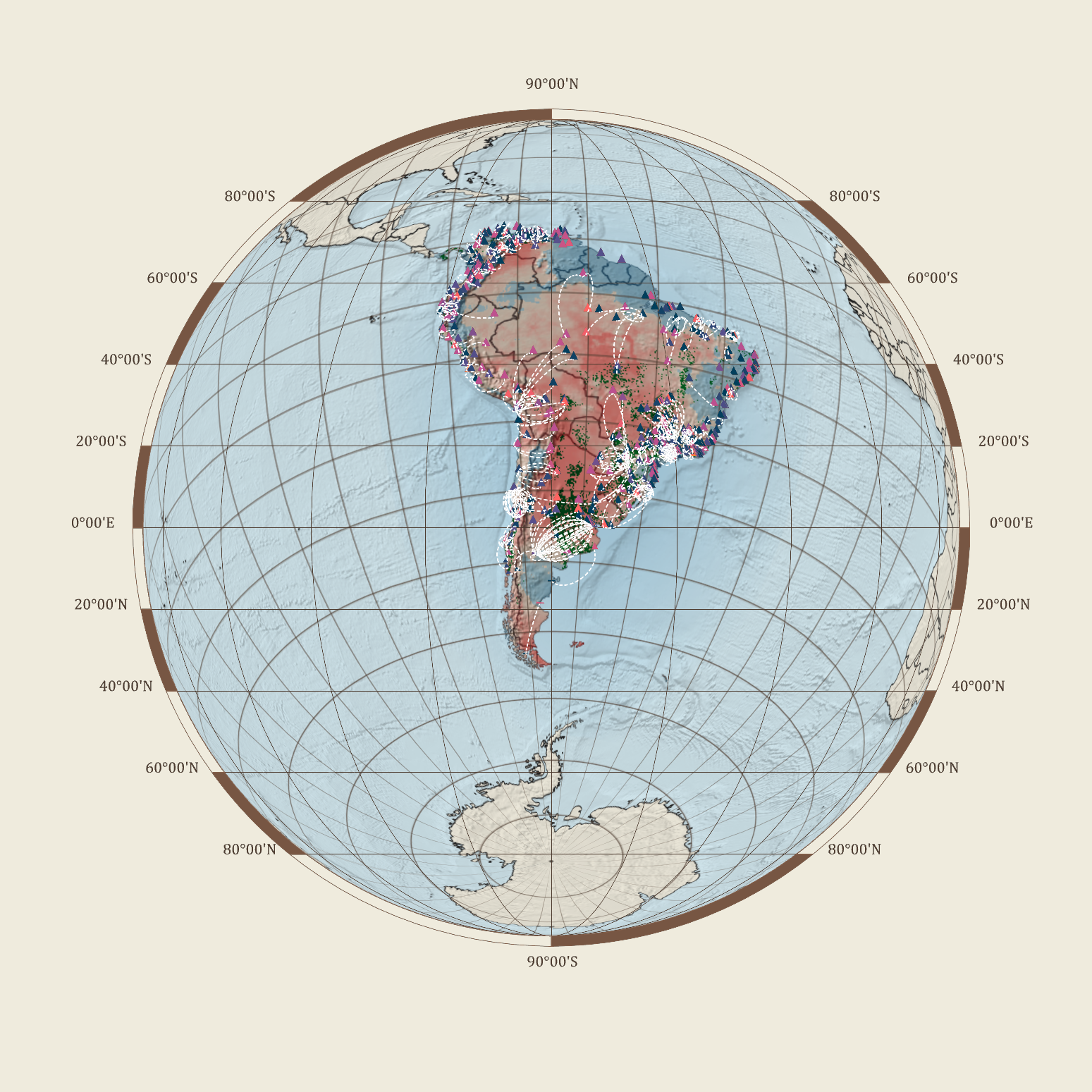
Routing Accessibility

Background Public transportation plays a crucial role in urban planning globally. Extensive research indicates that bus transit has become a highly favored mass mobility system. This preference stems from its cost-effective infrastructure, flexible planning, and discrete architecture that supports incremental growth. Bus transit systems exhibit lower infrastructure costs compared to rail or subway networks, making … Read more

MO.CA | media production

The main aim is to provide an insight as to what the students were experiencing and actively trying to achieve through every step of the process. This goal is to focus on practical visual storytelling strategies and skills through the work of the MAEBB Students. CLT PANELS MAKING OFThe media production team began with an … Read more

MO.CA | final thesis design

The brief for the MAEBB batch of 2022-23 was to design and construct an advanced ecological prototype mobile home. The home was to be designed for two individuals and basic domestic amenities of a tiny home. The mobility element of the brief started an interesting journey that brought forth discussions on nomadism and collective sustenance. … Read more

MO.CA | material production

This years Material Production started after the final design for the prototype was chosen and ran parallel to the further development of the design. The main goals were: – to monitor the amount, humidity and density of the locally sourced aleppo pine wood – to simulate production flows in the workshop (tools and time needed, … Read more

Xelajú-Digerible

El sistema alimentario como pilar estratégico para el desarrollo urbano de la zona 3, Quetzaltenango. Quetzaltenango, Guatemala. C.A El enfoque anteriormente abordado se centraba en la ecología y el cambio climático, exponiendo la situación actual de la ciudad de Quetzaltenango. Se identificaban los procesos alimentarios a través de la industria y cómo estas dinámicas contribuyen … Read more

MO.CA | final thesis construction

MO.CA construction sequence Thinking about the sequence of events was vital to a successful construction. With this cascading of events we were able to balance completing design details with progressing towards completion. Proper time management and scheduling was important to maintain momentum. The sequence informed our work in all stages: processing, assembly, and installation. Final … Read more

Wildlife Corridors

Our project focuses on modeling and predicting habitat fragmentation avoidance mechanisms using graphs. We investigate wildlife corridors in Australia, leveraging graph-based approaches to create coherent passages and connect forest areas. By analyzing satellite images, road data, and other metrics, we construct and evaluate graph models that incorporate forest containment, node characteristics, and connectivity. Our goal … Read more

ONE MUMBAI CITIZEN TOOL

INTRODUCTION Urbanization poses escalating threats to ecological systems, necessitating the creation of urban ecological commons. This exercise focuses on Mumbai’s metro network, comprising 357 kilometres, 16 lines, and 38 interchanges, as a context for enhancing neighbourhood biodiversity through strategic environment plugins. By leveraging NDVI mapping from Google Earth Engine, areas with high ecological threats and … Read more

SKYWARD CONNECTIONS

A Data-driven Approach of redefining the Accessibility of the Dispersed Urbanity of the Aegean Archipelago Accessibility is a multifaceted concept that expresses the case of access between two points in space. In the context of islands, accessibility is of utmost importance due to their inherent characteristics of isolation and small size. The Aegean Archipelago in … Read more

EASE GUIDE

 ‘Navigating Future Convenience’ PROBLEM STATEMENT The dataset contains information about previous trips taken by users, where each trip is represented as a node in the graph. The edges between the nodes represent connections between destinations visited by the same user. Additionally, the dataset includes attributes such as location details, amenities, time of day, activity type, … Read more

Routable

An Urban AI graft project based in Barcelona. In 2022 across both England and Wales the proportion of people that have some form of disability was a staggering 17.8% or nearly 10.4 million people. Our project is focused on urban mobility and aims to create accessibility for current routing applications have limited use for people … Read more

Compath

Problem statement and project objectives How can we create a routing system that orients onto its users environment, utilizing open source data? How do we collect and process data? Our objective is to utilize the existing data and generate any missing data required for each aspect of our analysis.  We combine data from different sources … Read more

Senseable Walks for Melbourne

OPTIMIZING THE EXISTING WALKABILITY INDEX Urban design plays a pivotal role in shaping the livability of a city, and walkability is a crucial aspect that directly impacts its residents’ quality of life. The City of Melbourne has developed a Walkability Index. This project aims at optimizing the existing framework by integrating key parameters related to … Read more