IAAC’s Master in City & Technology (1 or 2-year program) is a unique program oriented towards redefining the analysis, planning, and design of twenty-first-century cities and beyond. The program offers expertise in the design of digitally enhanced, ecological and human-centered urban environments by intersecting the disciplines of urbanism and data science. Taking place in Barcelona, the capital of urbanism, the Master in City & Technology is training the professionals that city administrations, governments, industries, and communities need, to transform the urban environment in the era of big data.


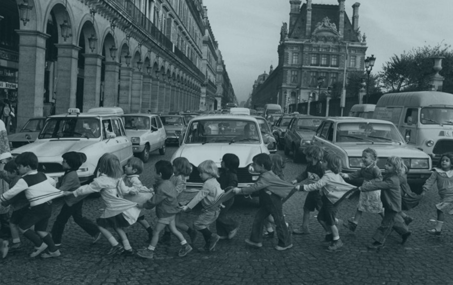
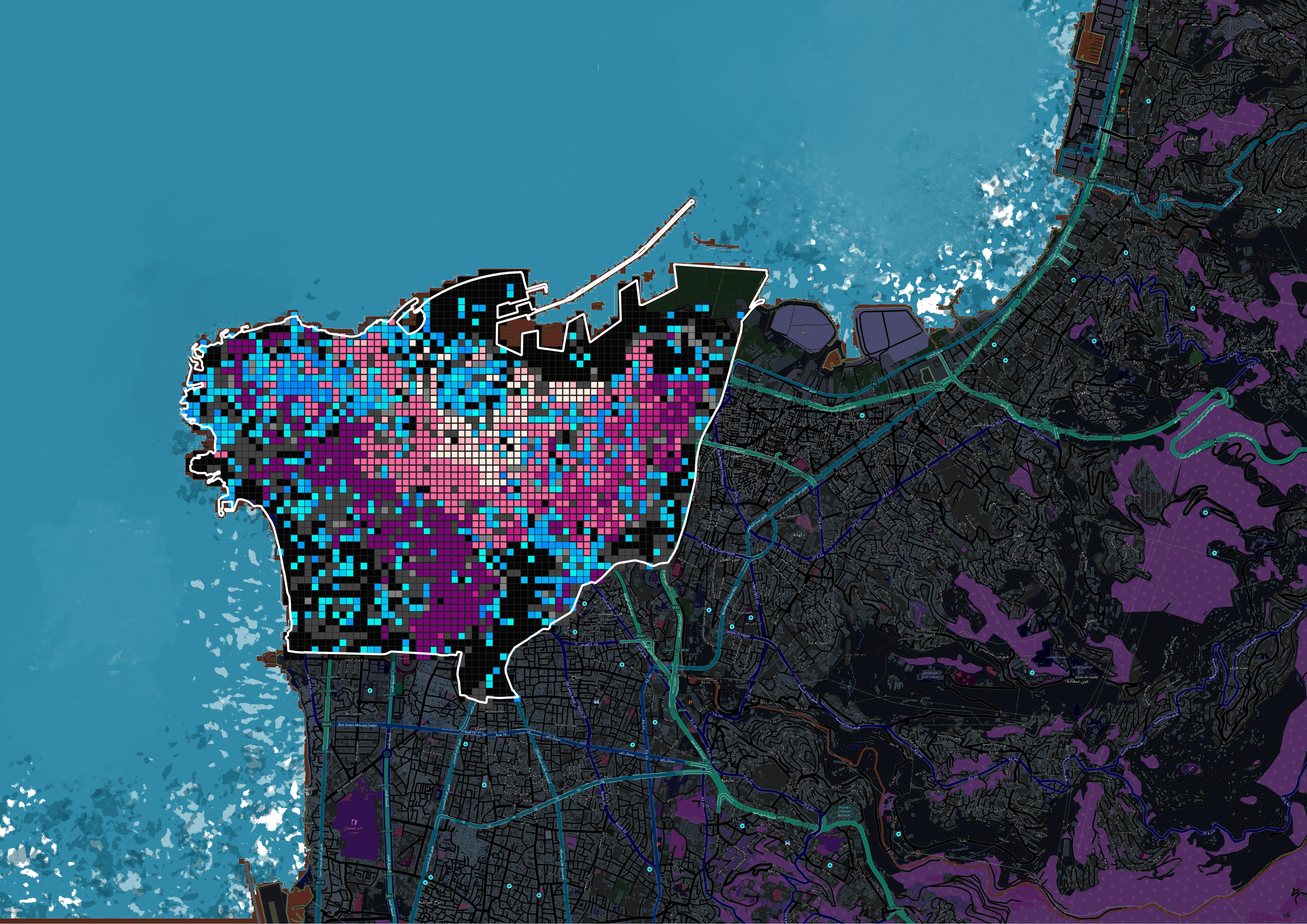
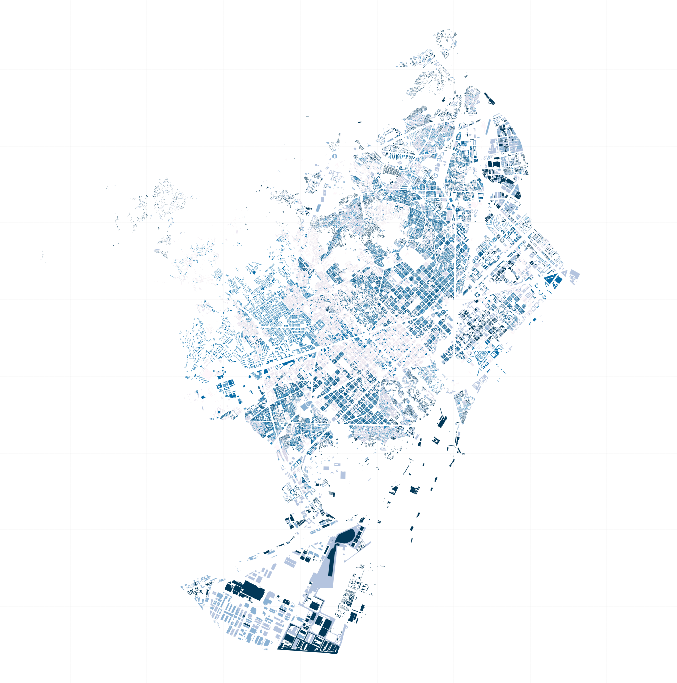
Identifying safe spaces

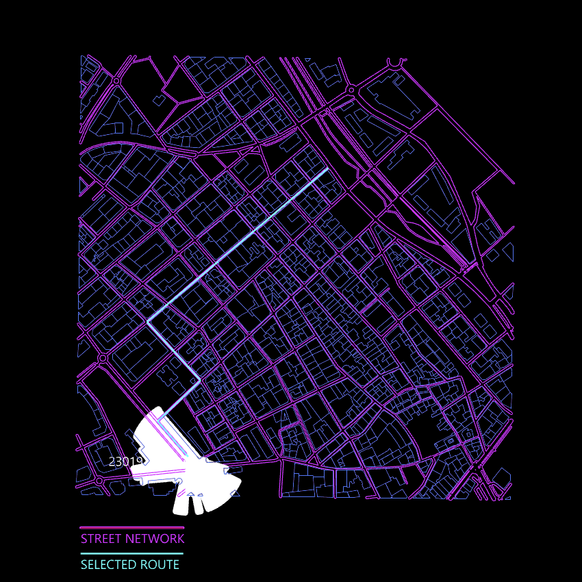
Using a visiblity map in the residential district of Montserratina in Viladecans, Catalunya, we aim to identify which junctions in the most popular route or routes are safe and what street typologies promote safety. VILADECANS We were working on a project that had as an objective to create healthy and safe spaces for the city … Read more

Nth Dimensional Chess

Introduction The objective of this Data Science project is to investigate the possible evolution that the value of a chess piece may experience when they’re allowed to move on a board of higher dimensions. The project will analyse the movement of the chess pieces beyond the 2d plane and onto the 3d cube, 4d hypercube … Read more

Questioning the Urban

Embarking on the intersection of artificial intelligence and theoretical discussions, imagine a digital voyage where sophisticated tools act as investigative aides. Think of it as the analytical companion dissecting context, sentiments, and core concepts—a literary detective in the digital world. It takes a visual turn with topic modeling weaving a tapestry of themes, and network … Read more

Navigating Inequality

Introduction Wealth disparity leads to social and economic challenges resulting in social exclusion. 21.6% of population in the EU are at risk of social exclusion. A study confirmed that 61.7% of socially excluded people tend to be segregated. Understanding the origin of the word Segregation – initially used to set sheep apart from the flock, … Read more

Routing Accessibility

Background Public transportation plays a crucial role in urban planning globally. Extensive research indicates that bus transit has become a highly favored mass mobility system. This preference stems from its cost-effective infrastructure, flexible planning, and discrete architecture that supports incremental growth. Bus transit systems exhibit lower infrastructure costs compared to rail or subway networks, making … Read more

Environmental Asset Resilience

The Environmental Asset Resilience (EAR) Tool is a response to the pressing global challenge of environmental instability, particularly in urban areas. These areas face substantial costs associated with environmental problems and climate change. However, decision-making in addressing these issues is complicated by conflicting priorities, limited resources, and a lack of expertise. The EAR Project aims … Read more

1 m/s Pathways: Navigating Urban Childhood

Challenges The projection by UNICEF indicating that 60% of the global child population will reside in urban areas by 2025 demands a critical reevaluation of our cities’ readiness for such a transformation. This shift presents unprecedented challenges and opportunities. By examining the fundamental challenges faced by urban childhood today, it becomes evident that the significant … Read more

BEYlink

TO RE-CONNECT AND RE-FRAME THE USE OF URBAN VOIDS “Beirut is among the many post-conflict cities grappling with dynamic and unsettled social, economic, and geographical dynamics.” “This thesis delves into the expansive realm of urban development within such cities, with a specific focus on the challenges of planning and innovative policy approaches.”  “ Beirut’s urban … Read more

POCKETHUB

Public spaces in a city, such as pathways and non-constructible parcels, are not utilized to their full potential. As a result, they create voids and detachment of citizens from their city and do not provide any meaningful benefits to the community. By using machine learning algorithms as a tool for a public organization to identify … Read more

EcoVision.AI

OVERVIEW Rapid urbanization and agricultural intensification have led to extensive land cover change, with urban areas expanding and natural landscapes transforming into fragmented environments. These changes generate climate change impacts, affecting urban areas, and creating a cyclical relationship. Advancements in remote sensing are crucial for comprehensively assessing and monitoring the impact of rapid urbanization, agricultural … Read more

FOLLOWing FOOT.AI

Unraveling Footfall Patterns for Enhanced Urban Planning: A Spatial and Temporal Analysis Introduction Footfall prediction plays a crucial role in urban planning decision-making processes. Understanding the intricate relationship between footfall and its two dimensions—space and time—is essential. In this project, we delve into the workflow and key findings of a project aimed at comprehending the … Read more

Potential Building Stock in need of Renovation or Demolition

The BCN Building Stock project aims to assess the condition of the building stock in Barcelona (BCN) and identify potential buildings that require renovation or demolition. This analysis is crucial for urban planning and sustainable development initiatives, as it provides insights into the state of the city’s building stock. By leveraging data analysis techniques and … Read more

GenCity.ai

Alejandro Aravena, renowned for his role in facilitating the recovery of a city struck by an earthquake and a tsunami, asserts that Participatory design transcends mere inclusivity and offers enhanced efficiency. Conventional methods may not yield the desired effectiveness, necessitating a reevaluation of the tools employed for participation.Barcelona, for instance, has already experimented with a digital … Read more

ONE MUMBAI CITIZEN TOOL

INTRODUCTION Urbanization poses escalating threats to ecological systems, necessitating the creation of urban ecological commons. This exercise focuses on Mumbai’s metro network, comprising 357 kilometres, 16 lines, and 38 interchanges, as a context for enhancing neighbourhood biodiversity through strategic environment plugins. By leveraging NDVI mapping from Google Earth Engine, areas with high ecological threats and … Read more

SKY COMPUTE

INTRODUCTION Climate change is an imperative global concern demanding meticulous attention. Its ramifications encompass an array of profound consequences, necessitating urgent action. Rooted in anthropogenic greenhouse gas emissions, this phenomenon engenders a persistent alteration in Earth’s climate patterns, characterized by escalating temperatures, heightened incidence of extreme weather events, and encroaching sea-levels. In this context, comprehending … Read more

SKYWARD CONNECTIONS

A Data-driven Approach of redefining the Accessibility of the Dispersed Urbanity of the Aegean Archipelago Accessibility is a multifaceted concept that expresses the case of access between two points in space. In the context of islands, accessibility is of utmost importance due to their inherent characteristics of isolation and small size. The Aegean Archipelago in … Read more

Construction & Demolition Waste Transportation Improvements, Barcelona

22@, an ongoing project in Poblenou, Barcelona aims to promote sustainable development and enhance the quality of life for its residents. However, one of the current challenges faced by the project is the significant noise and air pollution caused by the transportation of construction and demolition waste (CDW) from construction sites to landfills, which adversely … Read more

GENDERED GEOGRAPHIES

Navigating Urban Realities through Women’s Perception of Safety Cities all over the world are being quantified and rated in terms of their livability and life quality for better understanding of citizen satisfaction.  Safety, including both the tangible aspects and the subjective perception of safety, is a critical component in assessing urban life quality. According to … Read more

The 3-30-300 Rule

TRANSFORMING CITIES INTO URBAN FORESTS This principle, proposed by Cecil Konijnendijk, highlights the significant role played by urban forests and other forms of urban nature in promoting our health, well-being, and resilience to climate change. It acknowledges the need to consider various aspects of urban forests to achieve success. It also emphasizes the importance of … Read more

20 minute neighborhoods in Melbourne

-Problem statement- The extensive sprawl of Melbourne and the affordability challenges have led to a situation where purchasing a home in the central area is increasingly difficult. This situation urges residents to seek housing options in the outskirts, as a result consequently contributing to the city’s expanding boundaries. -Aim of the project- In the city … Read more

GenCity – An intervention enabler for Co-creating Urban Designs

Alejandro Aravena, renowned for his role in facilitating the recovery of a city struck by an earthquake and a tsunami, asserts that Participatory design transcends mere inclusivity and offers enhanced efficiency. Despite recognizing the significance of public participation in urban planning, we delve into the persisting factors that hinder its optimal efficiency. Conventional methods may … Read more

Green Printing

Urban Green Spaces are critical urban infrastructure – equally important to how our city functions as transport networks, and particularly vital to the wellbeing of our community. Urban greening supports Melbourne’s economy, providing cooling and amenity which supports the pedestrian economy and reduces operating costs for local businesses. Melbourne is encouraging more innovative methods for … Read more