IAAC’s Master in City & Technology (1 or 2-year program) is a unique program oriented towards redefining the analysis, planning, and design of twenty-first-century cities and beyond. The program offers expertise in the design of digitally enhanced, ecological and human-centered urban environments by intersecting the disciplines of urbanism and data science. Taking place in Barcelona, the capital of urbanism, the Master in City & Technology is training the professionals that city administrations, governments, industries, and communities need, to transform the urban environment in the era of big data.


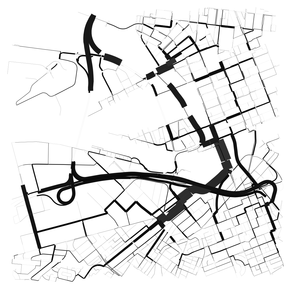
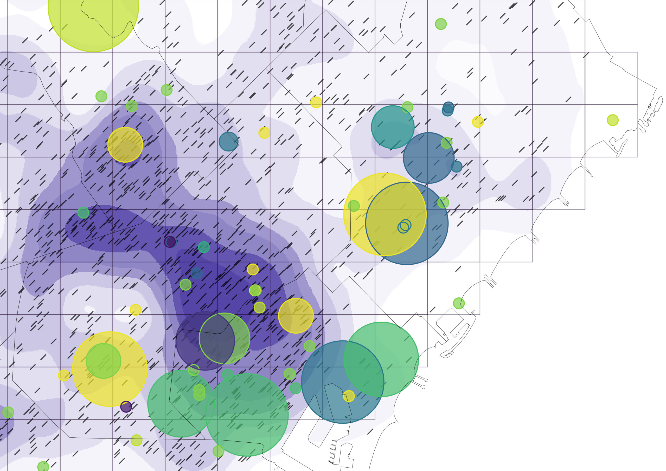
Routing Accessibility

Background Public transportation plays a crucial role in urban planning globally. Extensive research indicates that bus transit has become a highly favored mass mobility system. This preference stems from its cost-effective infrastructure, flexible planning, and discrete architecture that supports incremental growth. Bus transit systems exhibit lower infrastructure costs compared to rail or subway networks, making … Read more

ONE MUMBAI CITIZEN TOOL

INTRODUCTION Urbanization poses escalating threats to ecological systems, necessitating the creation of urban ecological commons. This exercise focuses on Mumbai’s metro network, comprising 357 kilometres, 16 lines, and 38 interchanges, as a context for enhancing neighbourhood biodiversity through strategic environment plugins. By leveraging NDVI mapping from Google Earth Engine, areas with high ecological threats and … Read more

Built Heritage vs Real Estate Market. The Barcelona case

python analysis BCN

Main question. How built heritage affects real estate market in European cities? Hypothesis Let’s look at this question on the example of Barcelona. Let’s single out the city neighborhoods (barrios) where historical buildings are located, and analyze the ratio of average real estate prices to them, in particular, the sale prices of apartments and houses. … Read more

Predicting the future densification Helsinki along its former transportation infrastructure.

OVER THE NEXT FEW DACADES HELSINKI EXPECTS TO ADD AROUND 250.000 NEW RESIDENTS IN 30-40KM OF TRANSFORMED MOTORWAY – LIKE HIGHWAYS PROJECT DESCRIPTION: In the future, a transition from highways and roadways to boulevards is anticipated due to a projected decrease in the number of cars. This shift is expected to address several issues commonly … Read more

Melbourne Meltdown X Space Syntax

The project attempts to understand correlations between several relevant factors of today where it aims at identifying the correlations between the mental health data of the city, urban heat island effect, land surface temperature, population, green areas, total neighborhood area, green ratio per neighborhood, NDVI values, distances in 500m to the green spaces, distances in … Read more

Remote sensing of the urban sprawl’s pace of Melbourne

urban growth Melbourne

Starting in 2015 urban development spread beyond the administratively defined Melbourne metropolitan area, into Greater Geelong and the Shire of Mitchell. The Melbourne Metropolitan Region or Greater Melbourne comprises 31 Local Authority Governments (LGA, municipalities and shires) aggregated in 6 metropolitan partnerships. Two of them, Inner and Inner South-East allocate the metropolitan core. This project … Read more

Housing for the Urban Poor

Considering the imminent demolition and in-situ rehabilitation of highly dense slum settlements, how might the application of generative algorithms facilitate the maximization and optimization of housing units within the existing spatial constraints? The slums and the unauthorized colonies are located across Delhi to identify which zones needs in-situ slum rehabilitation, there are over 700 slum … Read more

The Linear City Model

Optimizing Helsinki’s Boulevard Densification Method Helsinki, the vibrant capital of Finland, faces significant changes as it prepares for the future. With important challenges ahead such as the continuous population growth for the next decades and the associated risk of urban sprawl in suburban developments, the city must address the issue of land fragmentation by transforming … Read more

Mitigating embedded CO2 in the urban tissue of Singapore

Main challenge: densify city,  connect nature, and mitigate embedded CO2 Singapore is one of the densest countries in the World. Nature-conscious city densification has to consider reimbursement of natural patches within built environment, applying an connecting nature approach similar to a multi-tiered tropical forest. Mitigation of embodied carbon stays in  a row with nature connectivity. … Read more

‘Optimizing Barcelona’

Before the implementation of Cerda’s radical expansion plan, Barcelona was bound by their medieval walls and making every effort to accommodate its overflowing population. Cerda’s plan took into account scientific objectives that would create a city that is not just a well planned co-habiting space but also user-centric. Some of his objectives were gardens in … Read more

The City of Marvelous Disorder

The City of Marvelous Disorder is a study was conducted during the ‘CaaS studio (City as a Service): The future of cities’ services in the AI times’, that aims to built a methodology on mapping the creative sector and high education ecosystem of Barcelona, with a particular focus on social creative industry that works within … Read more

The Perks of Proximity

Clustering advanced industries to facilitate technology transfer in the Barcelona metropolitan region Spain has been at the forefront of pioneering research and innovation that have led to significant contributions to the world of technology. Technology Transfer Technology transfer from research to market seems like a straight-forward and linear process, but such is not the case. … Read more

Meteo sanctum

The project reflects on how people in ancient times defined natural and weather phenomena. The proposal is to create an open public space – Inspired by the concept of an ancient sanctuary with places that used to be built for worship and predictions of weather conditions, the Meteo Sanctum consists of digital indicators that allow … Read more

Bio-Digital Paths

“Bio-Digital Path” is a computational model of modular public spaces generated from emerging public movements within the existing urban fabric of Barcelona.  Global challenges consist of both environmental threats, but also social challenges and this project suggests that planners and architects actually have the tools to construct the public space not as a separate but … Read more

Digital space infrastructures

This is a short visual story about my personal digital space usage patterns and our need to be aware of our digital carbon footprint. Tracking my personal habits has revealed some shocking facts, which led towards reflecting on intangibility of the digital world, hopelessness in perceiving it as a hyper object and an urge to … Read more

SILENCED VOICES

An Exploration of the Epidemic of Femicide “How many more women must fall victims before we recognize that femicide is a real and pressing social problem that demands our attention? Despite its significance, many people are still unfamiliar with the term. Femicide is the ‘the intentional killing of a woman because of her gender‘. It … Read more

The Geography of Substance Use.

A Visual Story by: According to World Health Organization, 1/5 adolescents engage in some form of substance use. The Question of 100 School Phycologists: How planning could contribute towards the understanding of geographic patterns of substance use in order to distribute human resources all around the country? This visual story, seeks to explore the geographical … Read more

Towards Urban Democratic Adaptation

Adaptation districts towards prioritized urban interventions  in cities with limited green spaces.  The case study of the metropolitan area of Athens, Greece Athens, during the four last decades, has been extremely urbanized while changing the environment dramatically. By reclassifying open spaces and networks of urban mobility, this model aims to suggest strategies for prioritized urban … Read more

Decarbonization of Housing Stock in EU

Buildings are an intrinsic part of our lives, where we spend most of our time and unfold as human beings. However, through its different forms, the built environment is responsible for the majority of our energy consumption (around 40 %) and a primary source of greenhouse emissions GHG (around 36 %) (Anderson et al., 2015).  … Read more

“Are you Happy?”

Data visualization “World Happiness Report up to 2022” “Are you Happy?”“Yes! I am!!” You may answer immediately,  But I don’t answer like you.Of course,  I’m not unhappy but, “Happy??” Why don’t I say Yes? Is this due to national character? If I compare each country on the map, I may know some hints. Data quote:  Kaggle “World Happiness … Read more

The Scenic Route

Finding the greenest bicycle path that connects all the parks in Barcelona The shortest walk connecting all the parks was computed based on the road map. The existing bicycle lane does not connect all the parks in Barcelona. Hence, a second shortest path was created by pulling points from the road map to the bicycle … Read more

City of Proximities: Public Markets in Madrid

Madrid Public Markets SystemThe toolkit for municipalities, food delivery platforms and local residents 1/ Overall PerspectiveA first overview of the city of Madrid, throughout its administrative districts, their socio-demographics variables, the location of 46 municipal markets and the proximity patterns between them. 2/ Markets Around the Clock To allow citizens to engage with the markets … Read more

The Wild Deal

ABSTRACT Urban Rights is a term which has been coined by the philosopher Henri Lefebvre (Lefebvre, 1967)  and further explored by David Harvey (Harvey, 2003). It is a concept of a collective right to change the city and shape the process of urbanization. Thus, the right to the city does not merely address what the … Read more