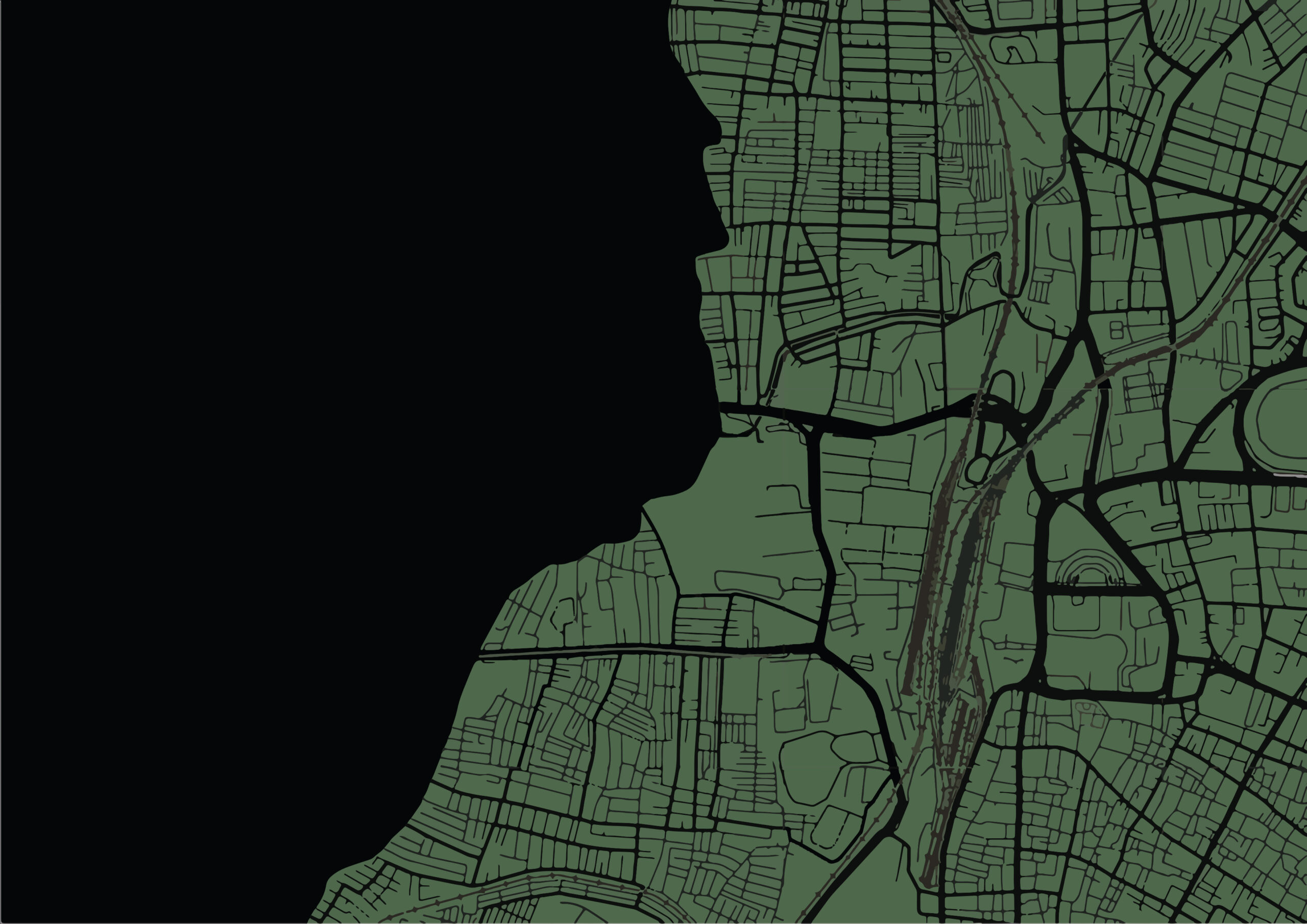
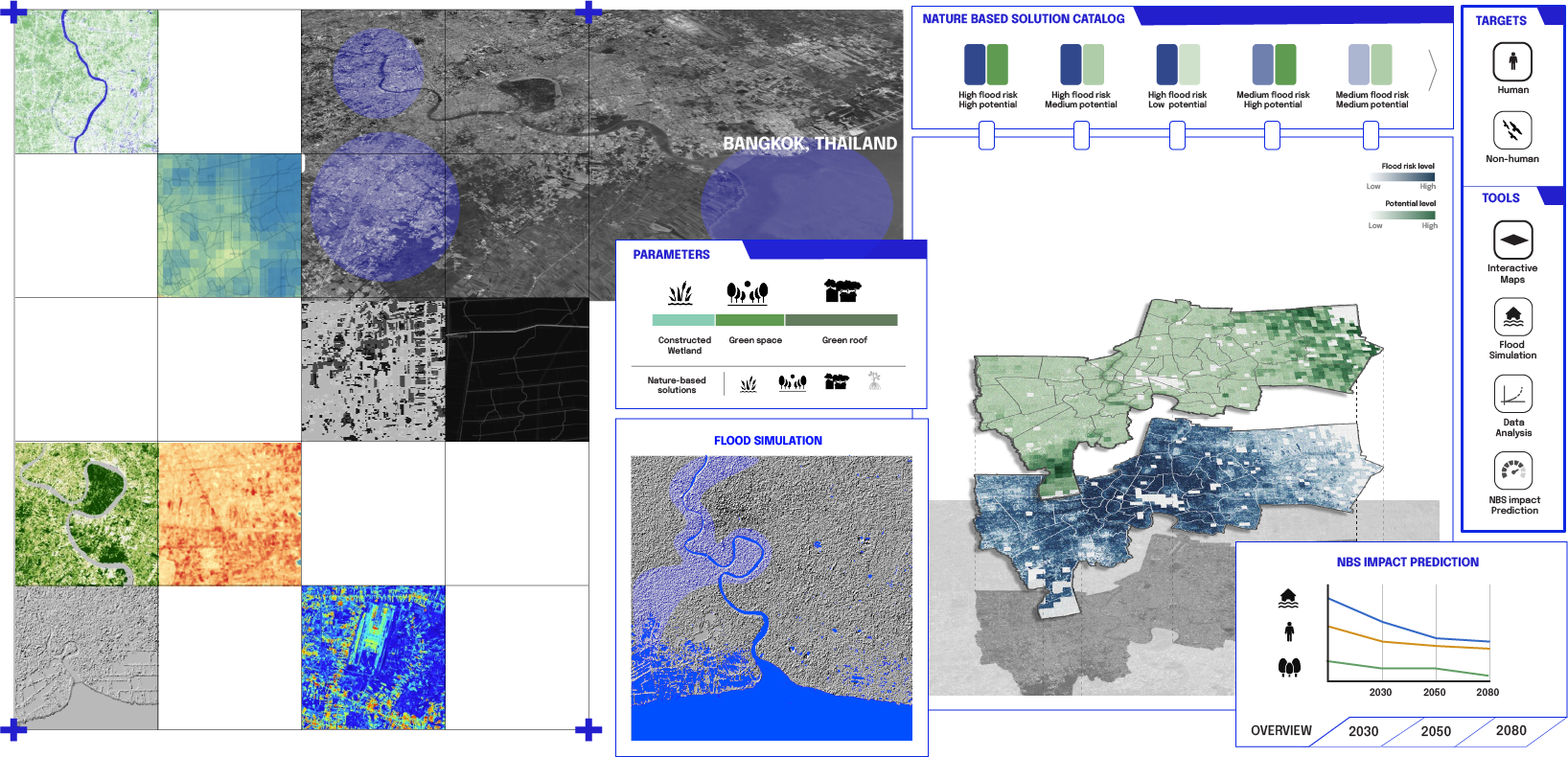
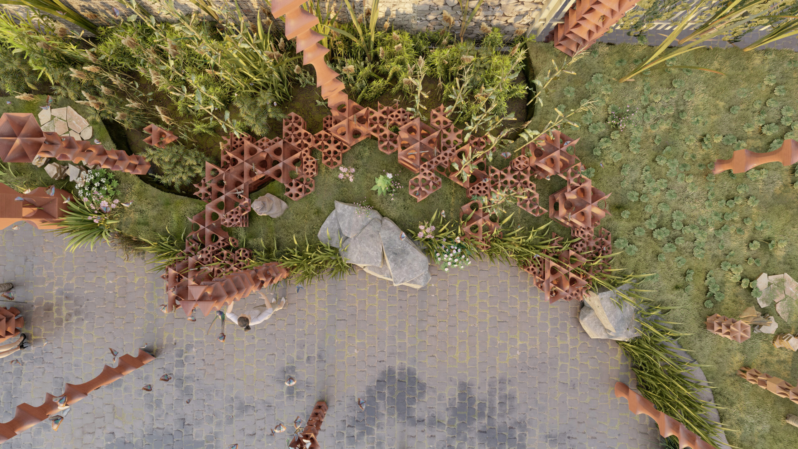
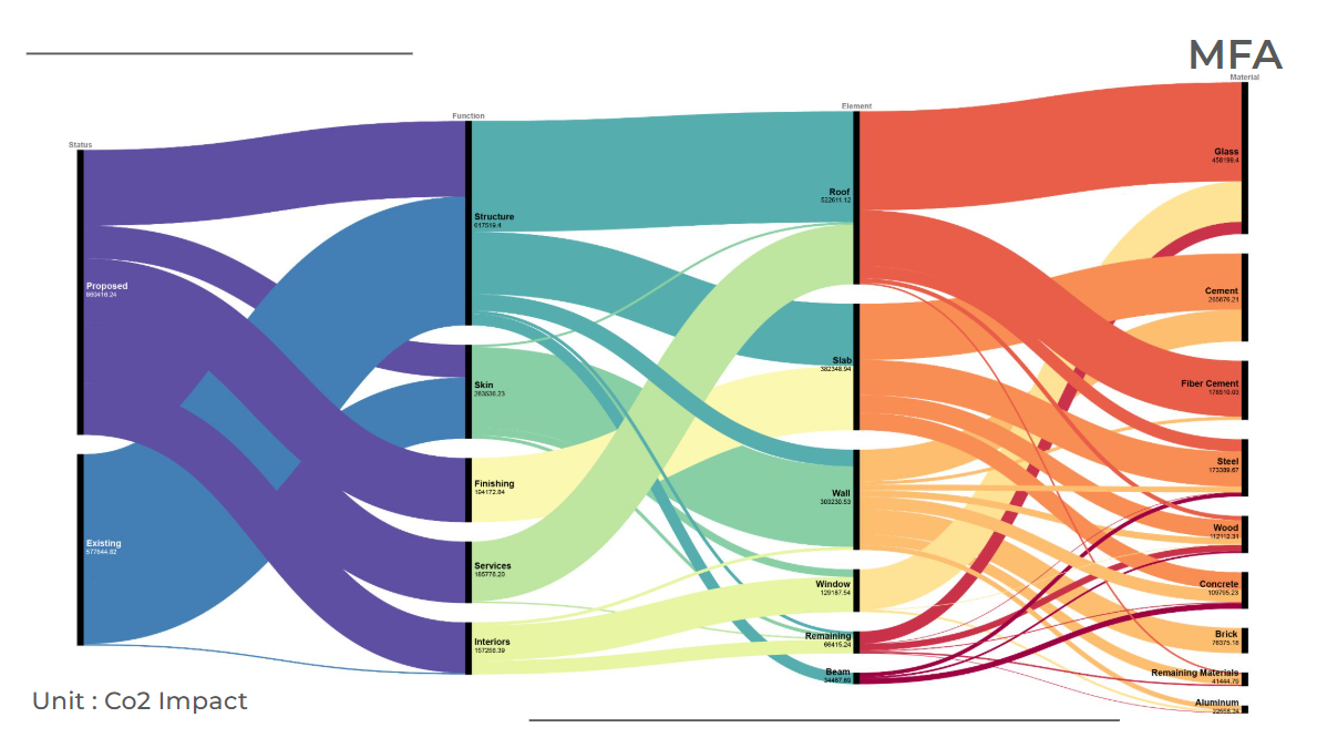
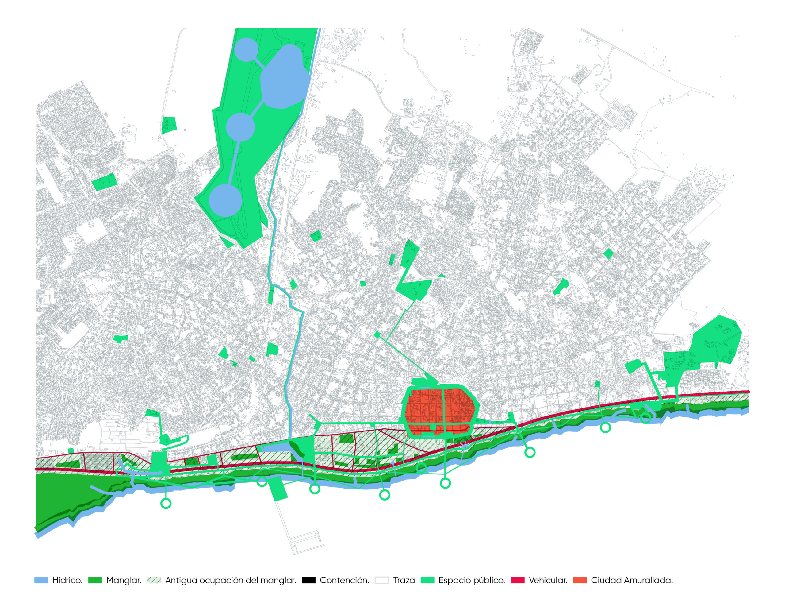
Project Sentinel: Predicative analysis of street lighting and safety
Greater Manchester, one of the largest and most vibrant urban centers in the UK, is characterized by its substantial student population and a dynamic economic landscape. With approximately 120,670 university students during the 2021/22 academic year and a significant number of these individuals studying at the University of Manchester and Manchester Metropolitan University, the region … Read more
Fields at Play
Fields at Play identifies the value of gender inequality in Olympic infrastructure and proposes to leverage the derived $12.6B Olympic gender gap in sports facilities to fund the revitalization and ongoing program of reliable, safe, and comfortable spaces for women at risk of gender-based violence. Understanding the purpose and outcomes of Olympic infrastructure strategies in … Read more
THF // MICRO-CITY
The proposed vision for Tempelhof is articulated as a ‘city within a city’ arranged along the two airstrips of the former airport, extending perpendicularly to emphasise a dual directionality. Buildings are conceived as flexible micro-communities built on organic/biodegradable materials, with the possibility of growing or ‘de-growing’ through time.The design strategy aims to trigger a need … Read more
GENDERED GEOGRAPHY: A SILOM SAFETY INITIATIVE
“WHAT IS THE FIRST THING THAT YOU THINK OF WHEN YOU HEAR THE WORDS: GENDER & BANGKOK? “ 1. BANGKOK’S SPECTRUM OF GENDER (INTRODUCTION) Historically, Thai society has grappled with rigid gender roles, which often saw Thai women facing significant challenges and being relegated to positions within the entertainment and sex industries. However, as Thai society … Read more
Kyoto Blossoms & Tourism Machine Learning
Project Focus For our Graph Machine Learning project, wanted to look at the city of Kyoto and Tourism Behavior around Cherry blossom patterns. Specifically, we set out to find out how cherry blossom patterns might affect the behavior and walking paths of tourists within the city. Data Sets We started by collecting our data sets … Read more
Invisible Barriers, Visible Caregivers
Introduction Medellin, known as the ‘City of Eternal Spring,’ is a Colombian city located between mountains around the Aburra River Valley. According to the National Census, it is inhabited predominantly by women, as 53.3% of the population is composed of women, and a large portion of them perform in areas such as education, healthcare and … Read more
Guidebook on Urban Degrowth
The Case of Tourism in Barcelona The “Guidebook on Urban Degrowth” explores applying degrowth principles in urban planning to promote social well-being and ecological equity in cities. This thesis develops guidelines to shift from high-consumption economic models to those that emphasize environmental balance and social equity. Focusing on Barcelona, it addresses the challenges of over-tourism, … Read more
Predict Yelp Ratings based on Urban Data using GML
Hypothesis The goal of this research was to investigate if open spatial data could predict Yelp ratings utilizing graph machine learning (GML) methods. We hypothesize that urban phenomena, events, and objects will indicate customer reviews and popularity, and therefore, could be used predict ratings. In particular, we perform edge classification using the DGL library. For … Read more
Temperature prediction in Argentina
Insights into the effects of weather data in Argentina, with implications for sustainable land management, deforestation and conservation policies, agriculture, industry and economies. Climate change, in particular the decrease in precipitation, is predicted to have significant effects on the living conditions in Argentina, affecting agricultural production, sea level rise, hydroelectric energy. The dataset composition consists … Read more
ReWeave_3.0
Abstract: The ReWeave project develops a robotic system to repurpose construction and demolition (C&D) waste into functional, attractive walls, enhancing human-robot collaboration. We created a database by scanning broken tiles to extract shape, size, and color information, then developed custom nesting algorithms to optimize tile arrangement. The workflow includes scanning tiles, exporting outlines via ROS, … Read more
100-Year Flood Risk Road Intersection Classification
Beginnings Our project’s concept is to develop a classification model that identifies street intersections (graph nodes) in Stockholm, Sweden, susceptible to flooding during a 100-year flood event. Based on our initial research, we found that graph machine learning operates at three levels: the graph, its edges, and its nodes. With access to a 100-year flood … Read more
IS THE FUTURE REALLY AUTONOMOUS?
1. Introduction 1.1. Abstract Autonomous Vehicles are vehicles that employ driver assistance technologies to remove the need for a human operator within the vehicle. These new technologies into automation have been researched in contexts like the United States of America, Middle-Eastern Countries and some European Countries. Planners and architects are designing for these cities including … Read more
Data Informed Trophic Cascade : a wetland recreation at Parc Diagonal Mar
Keywords : TROPHIC CASCADE – A trophic cascade occurs when a change at one level of the food web (often due to the addition or removal of a keystone species) causes a series of indirect effects on lower trophic levels. This can lead to significant and widespread changes in ecosystem structure and nutrient cycling. KEYSTONE … Read more
Ecologia Urbana en el área periurbana de São Paulo: Implantación de un Corredor Verde para Vincular el Crecimiento Urbano con la Naturaleza
Con más de la mitad de la población brasileña viviendo en áreas urbanas, la necesidad de integrar la naturaleza en la vida cotidiana se vuelve crucial. La urbanización desordenada alrededor de ríos y manantiales, como ocurre en la Represa Guarapiranga en São Paulo, compromete la cobertura vegetal, causando polución y amenazando la oferta de servicios … Read more