
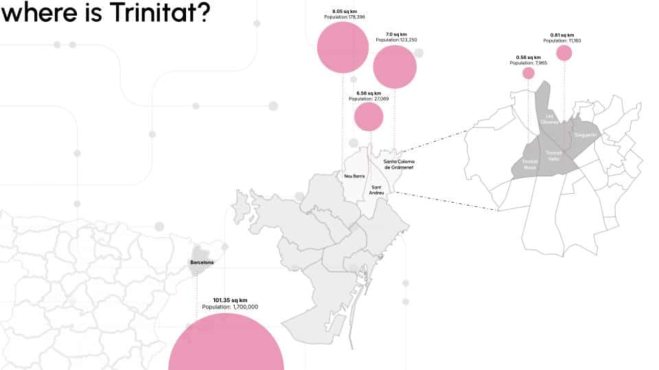
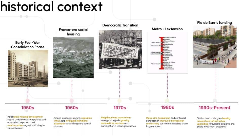
Infrastructure doesn’t just move people. It shapes who they are, where they go, and what kinds of lives are possible. At the northern edge of Barcelona — at the junction of Nou Barris, Sant Andreu, and Santa Coloma de Gramenet — Avinguda Meridiana does all three. It connects the city to its northern territories efficiently. And in doing so, it quietly tears two neighbourhoods apart.
Collectively Forward: Regenerative and Inclusive Urban Futures begins with that contradiction. It asks what happens when the logic of regional infrastructure meets the texture of everyday neighbourhood life — and it proposes not just a critique, but a computational, ecological, and community-grounded path toward repair.
The Condition: Fragmentation as a Systemic Problem
Trinitat Nova and Trinitat Vella share a boundary, a landscape system, and a social history. They do not share easy access to each other.
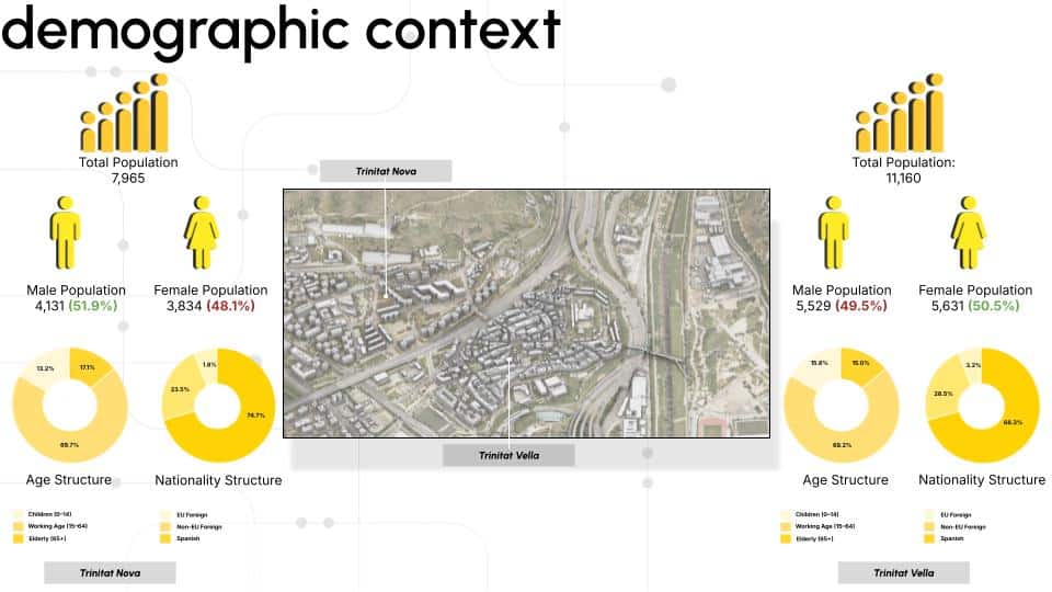
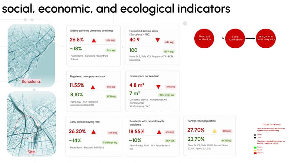
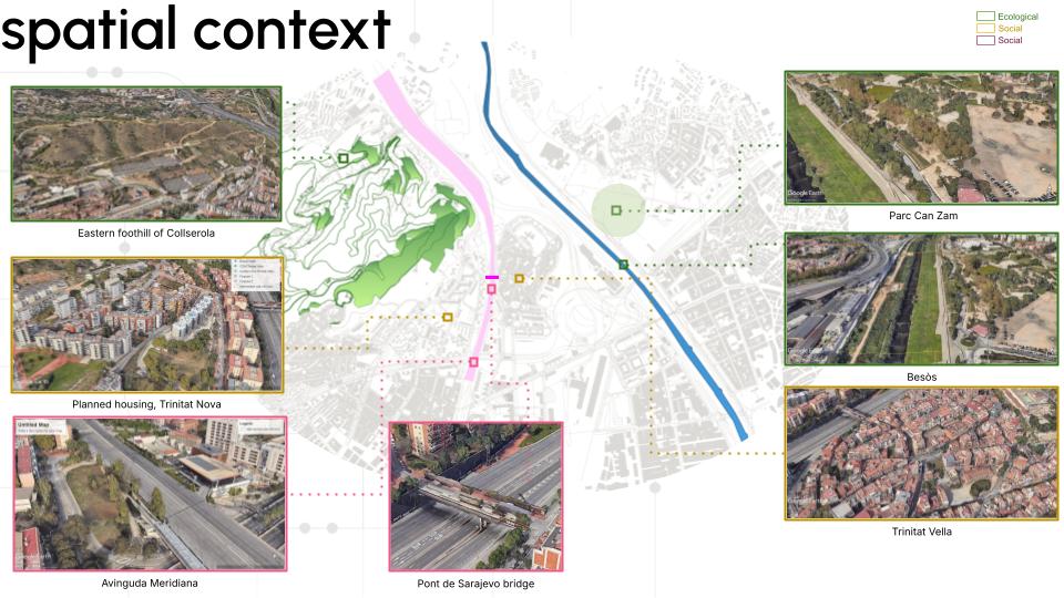
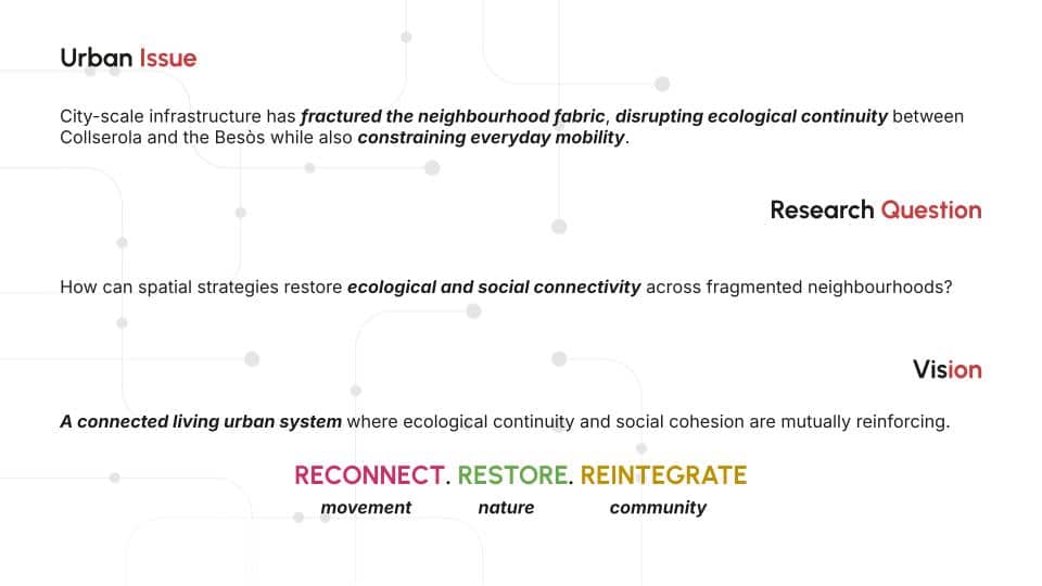
The Avinguda Meridiana and the B-10 corridor cut between them, functioning at the neighbourhood scale as hard spatial barriers — interrupting pedestrian movement, breaking ecological continuity between the Collserola foothills and the Besòs river system, and concentrating environmental stress along their edges. Both neighbourhoods fall significantly below Barcelona’s averages on indicators ranging from household income and employment to access to green infrastructure, school dropout rates, elderly isolation, and mental health. The fragmentation is not only physical. It is social, ecological, and environmental — layers of inequality reinforcing each other in space.
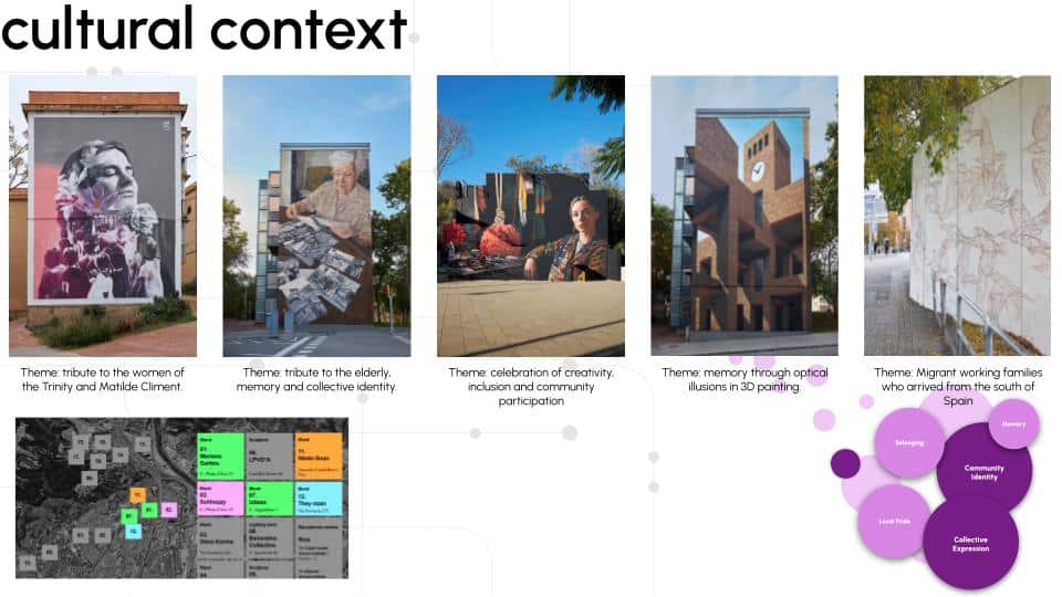
Yet residents maintain a deeply positive relationship with where they live. Interviews conducted across both neighbourhoods revealed strong attachments to affordability, community networks, and local identity. Large-scale murals in Trinitat Nova transform public space into expressions of collective memory. Community-led ecological initiatives demonstrate existing regenerative capacity. The site presents itself, simultaneously, as a condition of vulnerability and a landscape already in the process of repairing itself.
The project’s core argument is this: urban fragmentation is not a problem to be erased. It is a condition to be restructured — into connected socio-ecological systems that support both human and non-human urban life.
The Method: Data as Spatial Argument
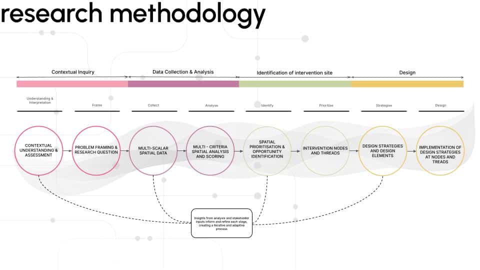
The analytical core of the project is a multi-criteria spatial analysis built across twelve layers covering physical, ecological, and social parameters — along with environmental analysis of heat exposure, noise pollution, demographic vulnerability, open space quality, and more.
A multi-scalar spatial vulnerability assessment framework was applied to identify critical intervention zones across Trinitat Nova and Trinitat Vella by integrating physical, ecological, and social parameters into a unified spatial model. Since the study area extends across different municipal boundaries with datasets generated at different spatial resolutions, all information was standardised through a 50×50 metre fishnet grid. This neutral spatial framework enabled the comparison of heterogeneous datasets by assigning a vulnerability score to each grid cell across the entire territory. The grid-based approach allowed urban fragmentation, environmental conditions, accessibility limitations, and social vulnerabilities to be analysed at a neighbourhood scale corresponding to everyday resident experience. Each cell was evaluated through a structured scoring system, generating a spatial database where multiple analytical layers could be combined to identify areas requiring targeted regeneration.
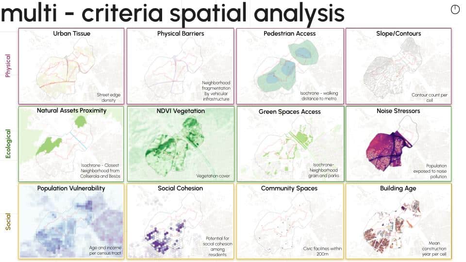
The assessment was developed through twelve analytical layers organised into three major dimensions: Physical, Ecological, and Social. The Physical dimension consisted of P1 Urban Tissue, P2 Physical Barriers, P3 Pedestrian Access, and P4 Slope/Contours, analysing urban morphology, infrastructure fragmentation, mobility constraints, and topographical challenges. The Ecological dimension included E1 Natural Assets Proximity, E2 NDVI Vegetation Analysis, E3 Green Space Access, and E4 Noise Stressors, evaluating ecological connectivity, vegetation performance, environmental accessibility, and exposure to urban stress conditions. The Social dimension incorporated S1 Population Vulnerability, S2 Social Cohesion, S3 Community Spaces, and S4 Building Age, assessing demographic sensitivity, community infrastructure, social networks, and the historical condition of the built environment. Each individual layer was converted into a spatial indicator and classified using a three-level fragmentation index, where higher values represented increased vulnerability and greater priority for intervention.
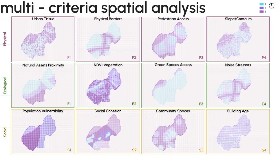
The scoring process applied layer-specific thresholds based on external standards, contextual references, and relative data distribution depending on the characteristics of each indicator. Accessibility-based parameters were assessed through established mobility standards, while ecological indicators such as vegetation coverage and proximity to natural systems were calibrated according to the Mediterranean urban context of Barcelona. Indicators without universal benchmarks were evaluated through relative classification methods to capture internal variation within the study area. The twelve scored analytical maps were then synthesised into three cumulative dimension maps: the Physical Cumulative Map (pC), generated by combining P1–P4; the Ecological Cumulative Map (eC), generated by combining E1–E4; and the Social Cumulative Map (sC), generated by combining S1–S4. These cumulative maps revealed the spatial distribution of fragmentation and vulnerability within each individual dimension while maintaining the relationship between the original analytical layers.
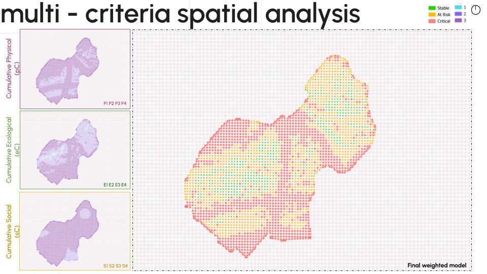
The three cumulative maps were subsequently integrated into the Final Weighted Model Map through a weighted aggregation of Physical, Ecological, and Social conditions. This final weighted model combined the three dimensions to identify overlapping vulnerability patterns and generate a spatial hierarchy of intervention priority. Physical and Ecological dimensions were emphasised as fundamental drivers for restoring connectivity, climate resilience, and ecological continuity, while the Social dimension ensured that areas experiencing higher community vulnerability were incorporated within the decision-making process. The resulting Final Weighted Model Map classified areas into different intervention priorities using natural data distribution patterns, identifying zones where multiple vulnerabilities converge. Rather than defining intervention areas through design assumptions, the model allowed the ecological corridor and regeneration strategy to emerge from measurable relationships between urban structure, environmental performance, and social conditions.
A Rule-Based Computational Framework for Urban Ecological Transformation
A rule-based computational framework was applied to analyse and guide ecological transformation strategies in Trinitat Nova and Trinitat Vella, shifting the design process from subjective planting decisions towards a data-driven methodology. The framework was used to establish measurable relationships between plant characteristics, urban conditions, and spatial performance requirements. Instead of selecting vegetation based on aesthetic preference, species were evaluated through ecological and functional parameters to determine their suitability within different urban contexts. The process integrated biological datasets, urban typology requirements, computational scoring, machine learning classification, and spatial performance analysis to generate site-specific ecological interventions.
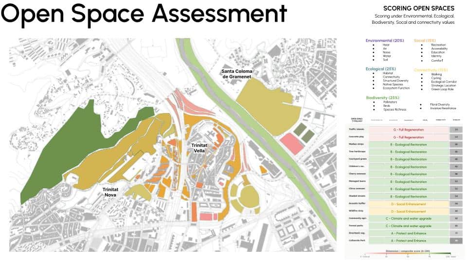
To establish a baseline understanding of the existing green and open space network, all publicly accessible open spaces within the study boundary were systematically identified and spatially delineated. Each space was then examined at a finer resolution to classify its typology and landscape characteristics, producing a comprehensive typological inventory. This classification revealed nineteen distinct open space categories operating across the neighbourhood fabric: Collserola Park, hillside wildfire prevention strips, formal urban parks, managed lawns with tree cover, visual and acoustic landscape buffers, riverbank vegetation zones combining turf and shrub layers, courtyard green spaces, community urban agriculture plots, community gardens, vegetated median strips, traffic island landscapes, tree-planted hardscape open spaces, children’s recreational landscapes, concrete playgrounds, shaded tree-lined streets, cherry blossom avenues, and citrus avenues.
Following typological classification, each open space was evaluated through a multi-criteria assessment framework structured across five performance dimensions: environmental value, ecological value, biodiversity value, social value, and connectivity value. Each dimension was scored independently, moving beyond static land-use classification to measure the functional contribution of each space to urban resilience, ecological continuity, social activation, and network integration. This performance-based evaluation framework enabled direct comparison across typologically dissimilar spaces by normalising qualitatively different spatial conditions into a common scoring system.
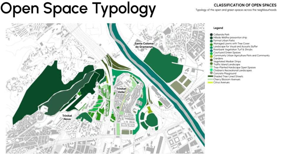
The resulting scores were spatially visualised to produce a performance map of the existing open space network, where each space is represented according to its composite and dimensional scores across the five criteria. This diagnostic layer exposed both high-performing nodes and underperforming zones, surfacing spaces with specific deficits in ecological function, environmental performance, biodiversity support, social activation, or network connectivity. Rather than treating open space as a uniform asset class, the framework differentiated between spaces that perform strongly across multiple dimensions and those requiring targeted remediation. These performance differentials directly informed the spatial logic of subsequent design interventions, ensuring that each strategy was calibrated to the specific functional gap or opportunity condition of its host typology — producing evidence-based, site-differentiated urban design responses rather than generic landscape improvements.
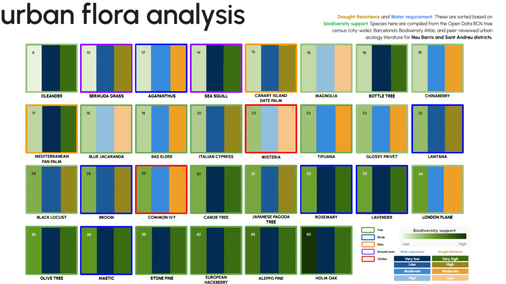
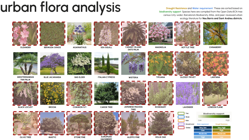
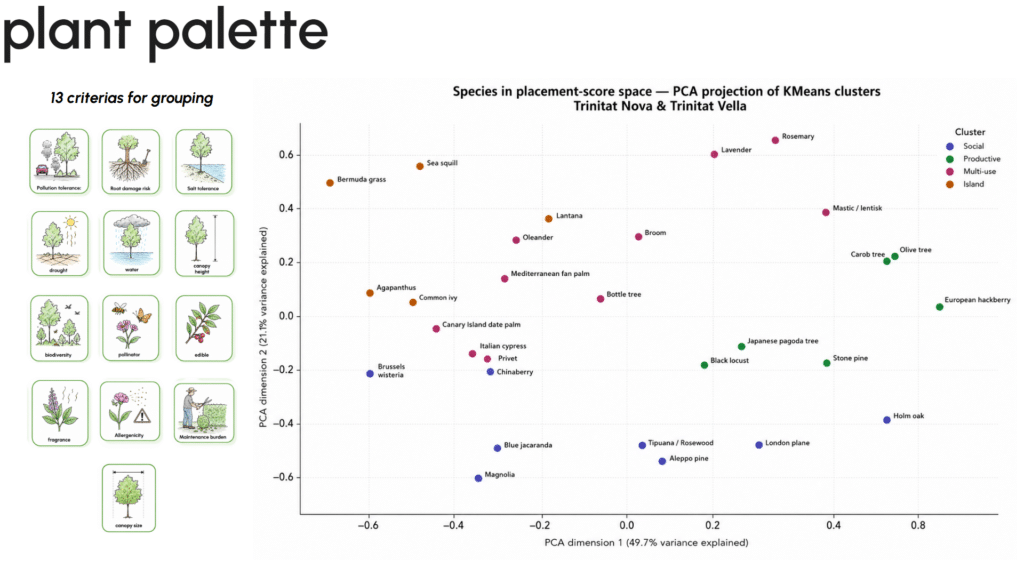
The framework began by developing a species performance database using 30 plant taxa identified from Barcelona’s urban ecological datasets and Mediterranean landscape research. Each species was analysed through a 13-dimensional trait matrix, including drought resistance, pollution tolerance, canopy capacity, biodiversity contribution, pollinator support, maintenance requirements, root behaviour, and sensory qualities. These ecological attributes were converted into measurable performance indicators and used to evaluate how different species could respond to specific urban conditions within Trinitat Nova and Trinitat Vella. The resulting dataset was then used to calculate suitability scores for different urban typologies such as road corridors, parks, traffic islands, social nodes, and productive landscapes, ensuring that each planting strategy was aligned with environmental, social, and infrastructural requirements.
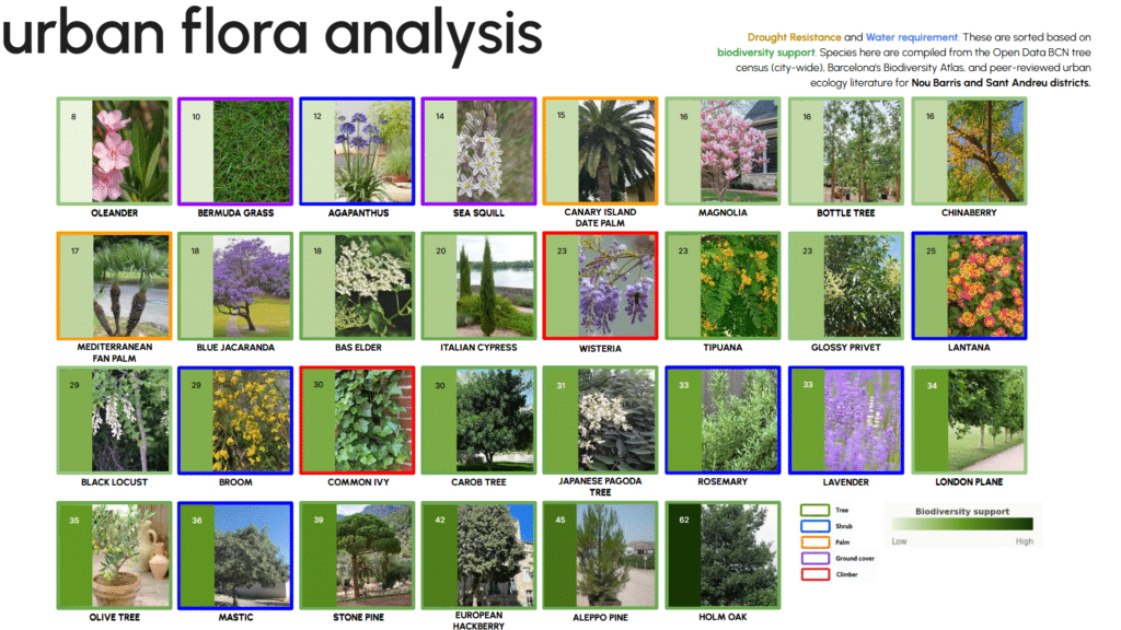
A computational clustering method was then used to identify ecological relationships between species and classify them according to their functional performance. KMeans clustering analysed the five-dimensional suitability scores to identify groups of species with similar ecological behaviour, while Principal Component Analysis was used to visualise similarities and differences within the dataset. This allowed the identification of species groups suitable for biodiversity corridors, climate-adaptive landscapes, public spaces, and habitat-supporting environments without relying on fixed assumptions. The same analytical logic was extended to open-space evaluation, where 16 urban space typologies across the neighbourhoods were assessed through 25 indicators covering environmental quality, ecological value, biodiversity performance, social usability, and connectivity potential. The weighted scoring model generated a composite performance value for each space, revealing areas requiring protection, enhancement, regeneration, or ecological improvement.
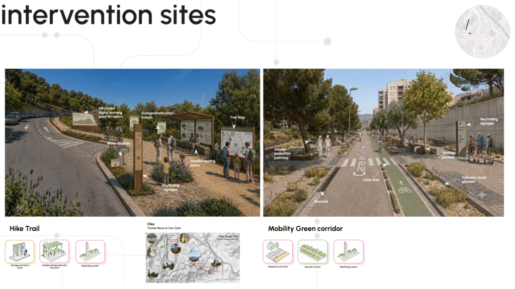
The final application of the framework was integrated into the masterplan development process by evaluating existing conditions and proposed interventions across key sites including , Hiking Path and Ecological Corridor; Mobility Corridors; Stormwater and Cycling Corridors; Edible and Productive Landscapes; Formal Urban Parks; Dense Layered Vegetation Buffers; Tree-Planted Hardscapes; Narrow Lane Interventions; Citrus and Cherry Blossom Avenues; Landscaped Lawns with Tree Cover; Restored River Edge; Former Penitentiary Edge Transformation; Metro Civic Gateway; Social Nodes; Children’s Playscapes; Community Centre Plaza; Tree-Covered Community Lawns; Besòs Bridge Connectivity; Sarajevo Widening Corridor; Green Pedestrian and Cycling Network. Each site was assessed through measurable changes across seven themes: ecological connectivity, water-sensitive design, climate adaptation, biodiversity enhancement, pedestrian mobility, community integration, and heritage education. The difference between existing and proposed performance scores quantified the impact of each intervention and identified which ecological and social factors contributed most to improvement. Through this process, the framework established a traceable connection between analysis, design decisions, and expected urban outcomes, creating a replicable methodology for implementing biophilic and regenerative urban strategies in fragmented neighbourhood landscapes.
Mapping Resident Voices Through Thematic Sentiment Analysis
We conducted a qualitative, rule-based thematic sentiment analysis on semi-structured interview transcripts collected from residents of Trinitat Nova and Trinitat Vella.
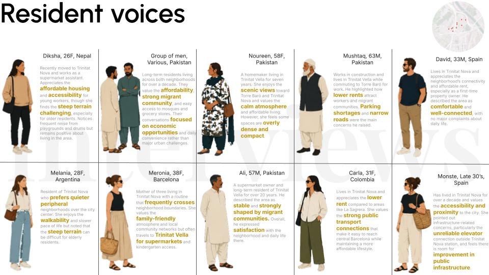
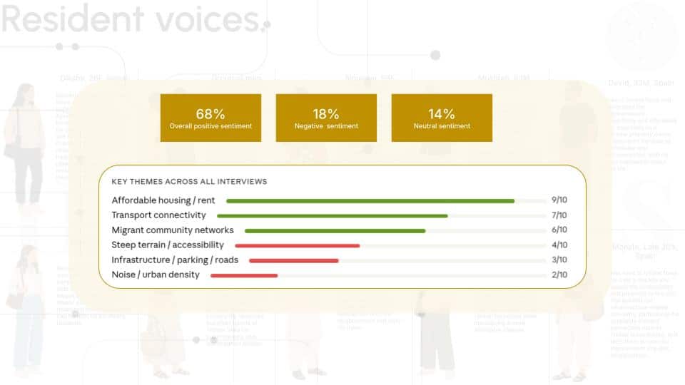
The process involved first transcribing and segmenting interview data into discrete meaning units, which were then subjected to manual thematic coding using a predefined coding framework. This framework classified responses into polarity-weighted categories representing lived experience dimensions: positive constructs (e.g., affordability, social cohesion, neighbourhood attachment, perceived accessibility) and negative constructs (e.g., mobility barriers, infrastructural degradation, spatial fragmentation, and connectivity deficits).
Each coded thematic instance was assigned a polarity value (positive/negative), and sentiment scores were derived through aggregated frequency-based weighting of coded themes per respondent. The final sentiment output represents a normalised ratio of positive-coded thematic occurrences to total coded occurrences, rather than lexical or machine-inferred sentiment intensity.
This allowed the transformation of qualitative narratives into a structured comparative metric, enabling cross-neighbourhood interpretation of experiential conditions.
The results indicate a predominantly positive sentiment orientation across respondents, despite the recurrent identification of structural and infrastructural constraints. This suggests that social cohesion and affordability act as dominant stabilising variables in shaping neighbourhood perception, producing a strong baseline of social resilience even within contexts of physical and infrastructural limitation.
The Vision: A Connected Living System
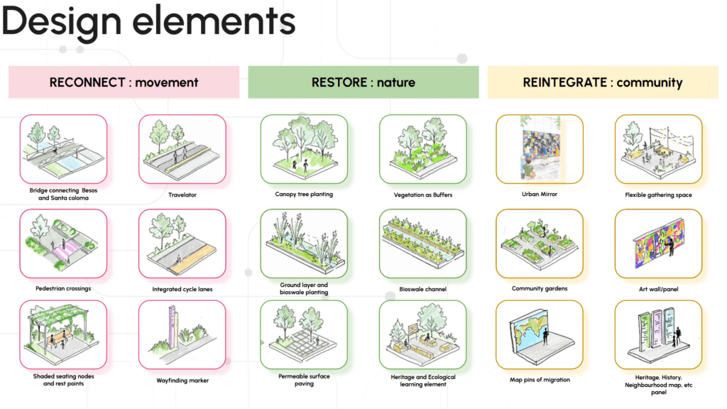
The design framework operates through four integrated strategies.
Ecological continuity creates habitat corridors connecting Collserola, the neighbourhood fabric, and the Besòs river system — transforming discontinuous green patches into a functioning ecological network. Climate adaptation addresses thermal stress through connected canopy networks, bioswales, rain gardens, and shaded corridors that reduce urban heat at the street and block scale. Community activation introduces flexible public spaces — pocket parks, productive gardens, cultural plazas, and play landscapes — rooted in the existing social and cultural structures of both neighbourhoods. Pedestrian-first mobility reorganises movement hierarchies to prioritise walking and cycling, making slow connectivity the structural logic of the proposal.
A unified design toolkit — ecological bridges, travellators on steep terrain, biodiversity planting systems, community gardens, wayfinding systems, shaded seating — provides consistency across contexts while remaining adaptable to the varied spatial conditions of each intervention zone.
Socio-Ecological Regeneration for the neighborhoods
The Socio-Ecological Regeneration Framework establishes a connected urban system by restoring fragmented landscapes through ecological corridors, nature-based infrastructure, and climate-responsive public realm interventions. In Trinitat Nova, the Hiking Path and Ecological Corridor create a continuous ecological spine integrating interpretive systems, shaded nodes, and slow mobility infrastructure. Mobility Corridors enhance pedestrian connectivity through tree canopy, planting systems, and rest points, while Stormwater and Cycling Corridors combine active mobility with bioswales, rain gardens, and water-sensitive landscape strategies.
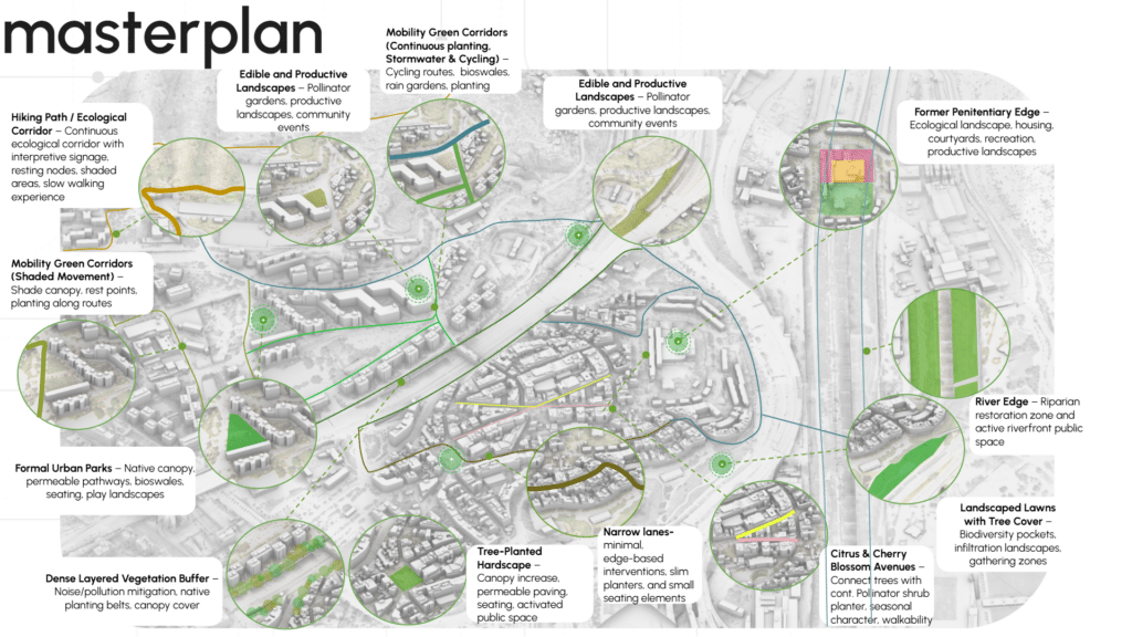
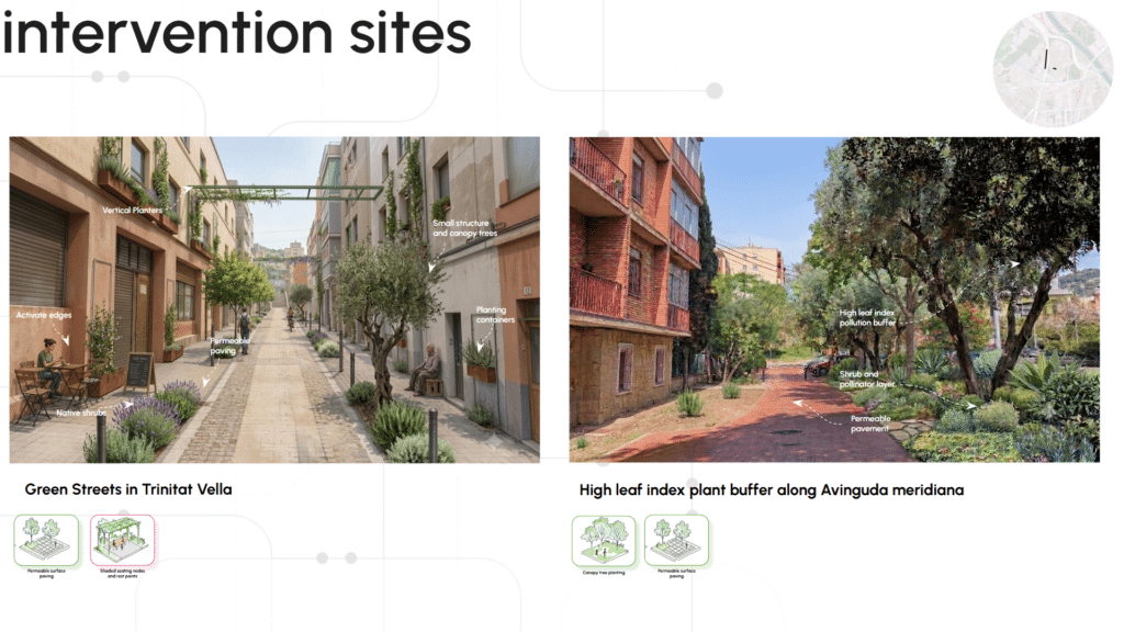
Ecological enhancement strategies include Edible and Productive Landscapes with pollinator planting and community-based productive systems, while Formal Urban Parks are strengthened through native vegetation, permeable surfaces, bioswales, seating, and play landscapes. Dense Layered Vegetation Buffers establish high-leaf-index planting belts to improve microclimate, reduce noise and pollution exposure, and enhance habitat connectivity. In Trinitat Vella, Tree-Planted Hardscapes improve canopy coverage, permeability, and public usability, while Narrow Lanes receive targeted edge-based interventions through planters and integrated seating. Citrus and Cherry Blossom Avenues, Landscaped Lawns, and River Edge restoration introduce biodiversity corridors, infiltration landscapes, riparian systems, and active waterfront conditions. The Former Penitentiary Edge is transformed into an ecological transition zone integrating housing, recreation, courtyards, and productive community landscapes.
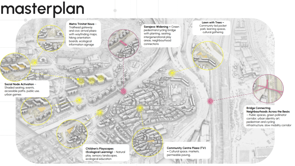
The social regeneration component strengthens civic interaction, accessibility, and neighbourhood connectivity. The Trinitat Nova Metro Station is transformed into an ecological gateway with a trailhead plaza, ecological wayfinding, and environmental interpretation. Social Nodes are activated through shaded seating, flexible gathering areas, and accessible public routes. In Trinitat Vella, Children’s Playscapes introduce ecological learning through natural play systems, while the Community Centre Plaza supports cultural activities, markets, and adaptable community use.
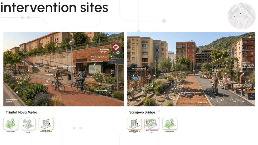
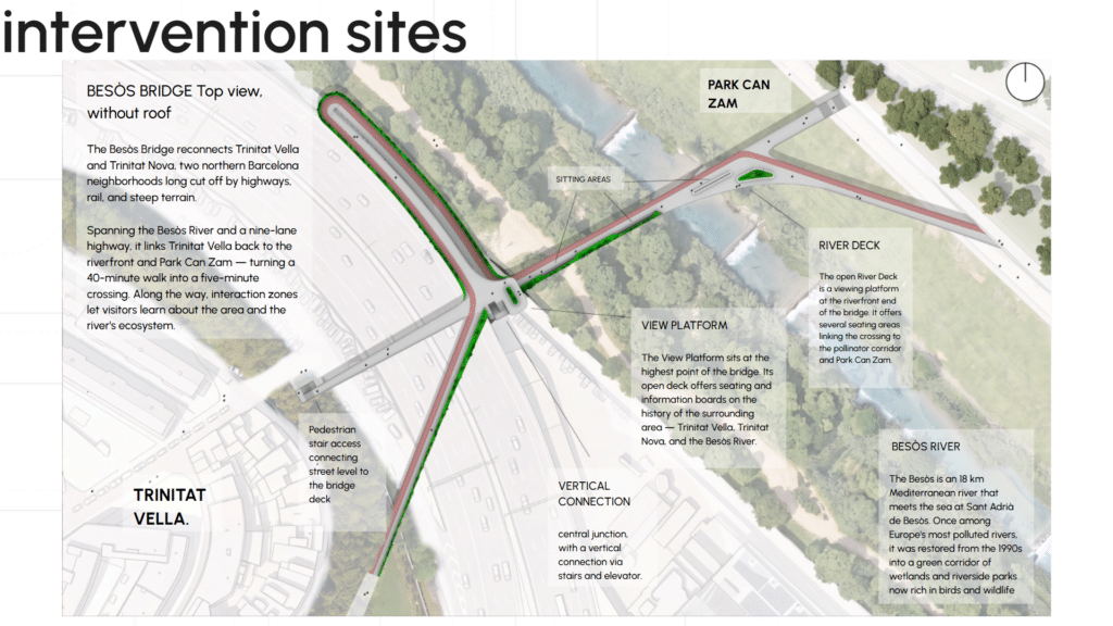
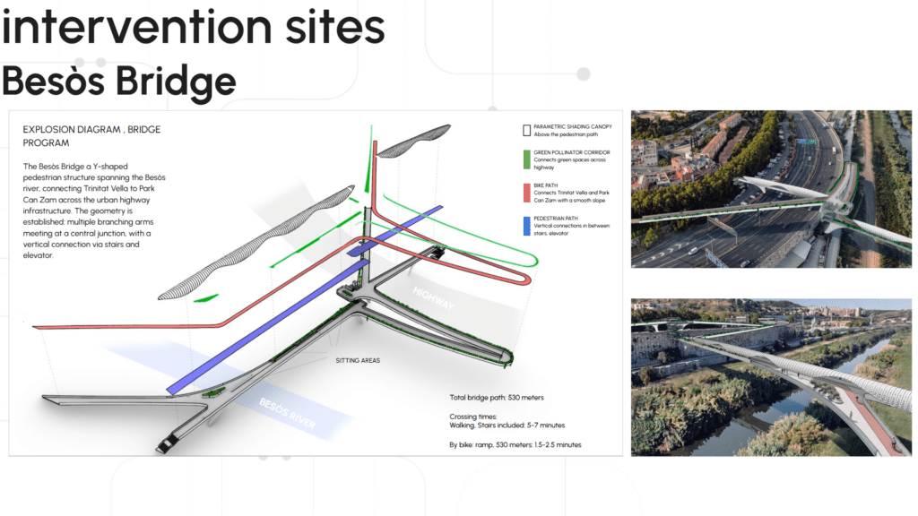
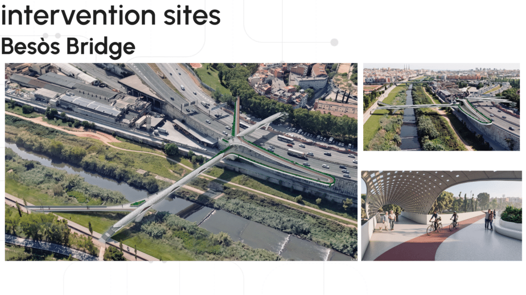
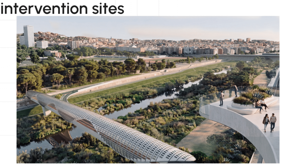
The connectivity strategy links Trinitat Nova and Trinitat Vella through the Besòs Bridge and Sarajevo Bridge widening, transforming infrastructural barriers into green pedestrian and cycling corridors. Integrated planting, seating, public art, and intergenerational spaces create continuous slow-mobility networks, converting fragmented urban infrastructure into a resilient socio-ecological system where biodiversity,
What This Project Is Really About
At its core, Collectively Forward is an argument about the role of data in urban design — not as a tool for optimisation at the expense of community, but as a method for making visible what is often rendered invisible: the accumulated weight of inequality, the spatial logic of exclusion, the ecological potential trapped inside fragmented urban conditions.
The 50-metre grid, the weighted scoring model, the species performance matrix — these are not ends in themselves. They are instruments for building a spatial argument rigorous enough to challenge the logic that produced Avinguda Meridiana as a regional asset and a local barrier simultaneously.
The project also reflects something important about where urban design practice is moving. The most interesting questions today are not about individual buildings or isolated public spaces. They are about systems — ecological, social, infrastructural — and how those systems either reinforce or repair the conditions that produce urban inequality. The response to infrastructure-induced fragmentation is not to add a park. It is to rebuild the connective tissue of the city itself.
Trinitat Nova and Trinitat Vella are two neighbourhoods at the edge of Barcelona. They are also a testing ground for what regenerative urban futures can look like when ecological continuity, community participation, and spatial intelligence work together — not as parallel agendas, but as a single integrated system.
