Visualizing GeoSpatial Data in Python – Going from Csv to Graph

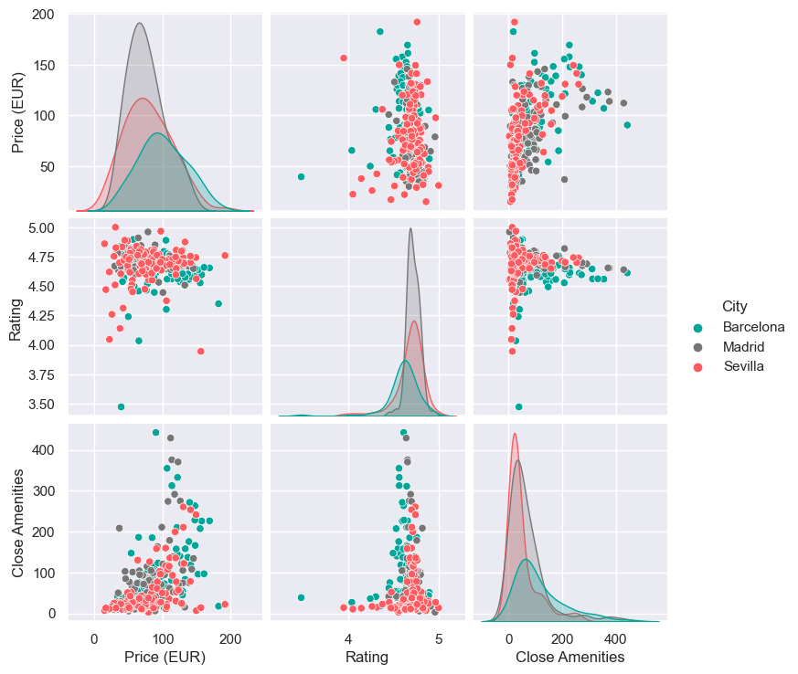
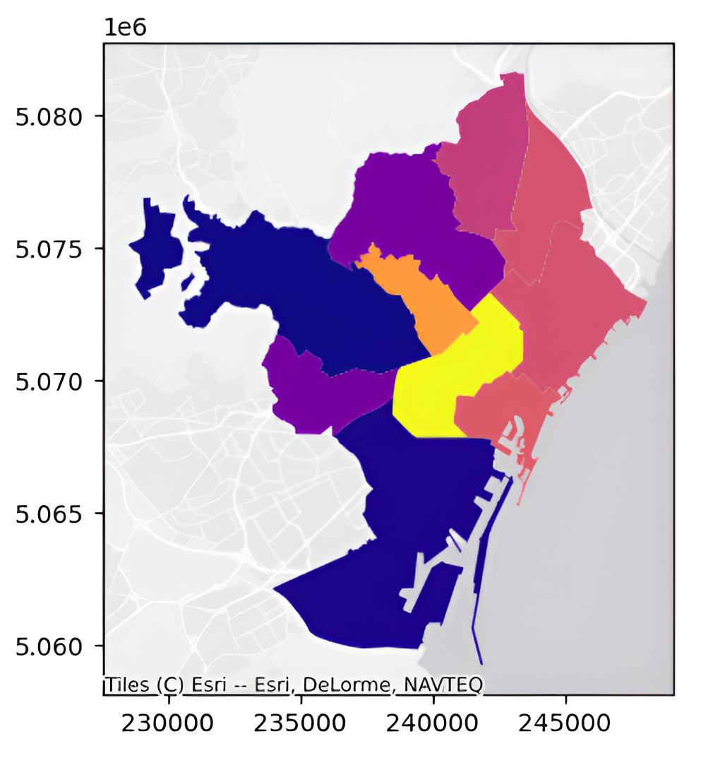
Visualizing dataframes using Geopandas and Plotly in Python introduction Python is a versatile and easy-to-learn programming language. GeoPandas extends the data manipulation capabilities of pandas to spatial data, providing a familiar and convenient environment for working with both tabular and geographical data. GeoPandas makes it easy to load, explore, and analyze geographical data. You can … Read more

Data Visualisation using Python

Introduction In today’s data-driven world, the ability to visualize data effectively is a key skill. This blog post introduces the fundamentals of data visualization using Python, a powerhouse in the data science toolkit. We’ll explore essential libraries like GeoPandas, Plotly and Contextily, guiding you through the process of transforming raw data into insightful, visually appealing … Read more

Comparing the land value estimation of Airbnb and the housing market

In this exercise, I visualised the relationship between the price of Airbnb accommodations compared to the price that the regular housing market puts. The visualisation consists of two datasets in csv format as well as a shapefile. The process started by cleaning the data so that equivalent columns in the csv’s could be matched. After … Read more

Note Palette

Music is visualized everyday – but is there any accuracy to its representation? Can sound be accurately represented? If so, what does it look like? How is accuracy measured? While not fully satisfied with the answers found to these questions, Python’s mido package shed light on the how sound and color may be linked through … Read more

Data Visualization Using GeoPandas in Python

1.Geospatial Mapping using GeoPandas in Python In Python, GeoPandas plays a crucial role in facilitating geospatial analysis through its powerful functions. I will illustrate the concise process of leveraging GeoPandas to create maps of Barcelona. This involves a systematic application of GeoPandas’ functions for effective geospatial data synthesis and mapping. Step 1: Loading GeoDataFrame from … Read more

LA CREMADA

The second year students of Master in Advanced Architecture (MAA) and Master in Robotics and Advanced Construction (MRAC) participate in Llum BCN 2024 with LA CREMADA / THE BURN, an immersive interactive installation that delves deep into the world of wildfires, their origins, impacts, and the critical need for understanding and prevention. The installation, located at Plaça Les Arts, C/ … Read more

Promised Land

Mesh representation of MIDI

Mapping America’s Genrescape Promised Land, Chuck Berry’s early representation of modern rock and roll, blurs racialized difference in genre origin, fueling the hybridization of genre categorizes, resulting in America’s current rich music tapestry. MIDI data correlated to synaesthetic representations of color is crystalized and in a dense three-dimensional mesh and place qualities are correlated to … Read more

Visualization of Complex Innovation Data using Python

Innovation is a buzzword these days, and everyone seems to be talking about it. However, truly understanding it is a different ball game. Take the Global Innovation Index by the World Intellectual Property Organization (WIPO), for example. It’s a massive framework that pulls data from top-tier organizations worldwide, scoring countries on 100+ indicators. It’s a … Read more

Shining Rebirth

Shining Rebirth is a project about the circular lives of float glass, aluminium frame and polycarbonate roofing. Related materials are taken from IAAC atelier, with numbers, dimensions and conditions properly analysed. Carbon footprint as each stage of life is calculated, with deconstruction steps properly considered. In order to propose a new life for these materials, … Read more

Visualising Genres: Investigating the Combination of Acoustics and Art in Multi-Material 3D Printed Walls

Brief Our curiosity brought us to an intriguing investigation at the nexus of technology, craftsmanship, and acoustics in the quest to elevate spatial design. This blog shares the story of our journey, where we used a cutting-edge multi-material 3D printing technique to produce personalized sound-diffusing walls—a first for the industry. Our concept began with a … Read more

Spatial.Revelations

Abstract This study delves into the innovative fusion of graph theory with architectural design and planning, facilitated by a structured BIM to Graph workflow. By conceptualizing architectural elements as nodes and their interconnections as edges within a graph, architects gain an adaptable and multifunctional tool for representation, analysis, and strategic planning. The graph’s inherent scalability … Read more

First step towards circular reconstruction. Damage assessment and material mapping of buildings in Ukraine through ground imagery processing.

An apartment building explodes after Russian army tank fire in Mariupol, Ukraine, March 11, 2022. (AP Photo/Evgeniy Maloletka)

Intro Russian full-scale invasion of Ukraine, which started on 24.02.2022, is the biggest war in Europe since WWII. It took the lives of dozens of thousands of Ukrainians and brought massive destruction [1] and ecological catastrophes. Some cities are completely erased. A massive piece of land is still occupied. This war and its consequences are … Read more

Advanced Architectural Guide

Abstract Architecture enthusiasts face a dilemma when planning their travel visits. Either they spend a lot of time and effort researching and planning their routes, or they can rely on mainstream websites and blogs that tend to recommend well-known works, ruling out works with the same architectural interest that have received less media coverage. The … Read more