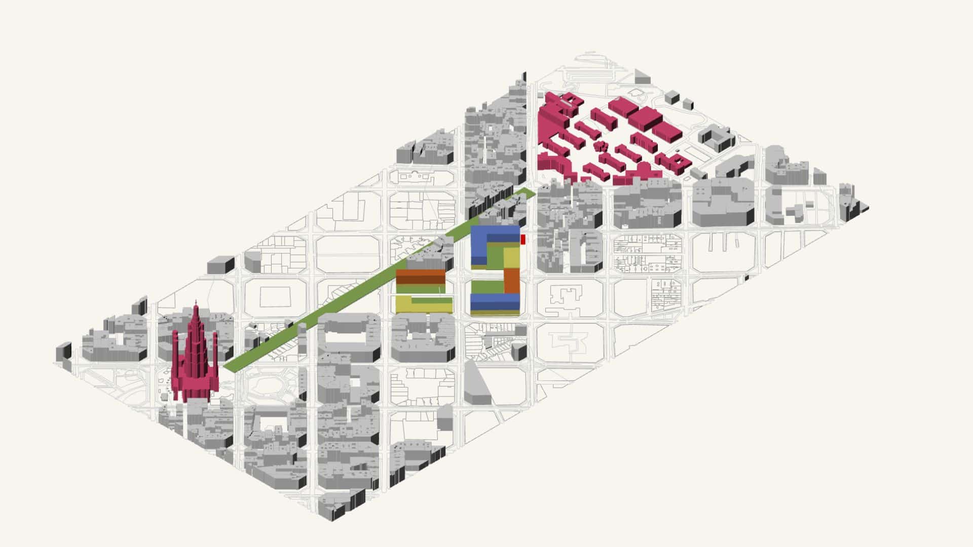
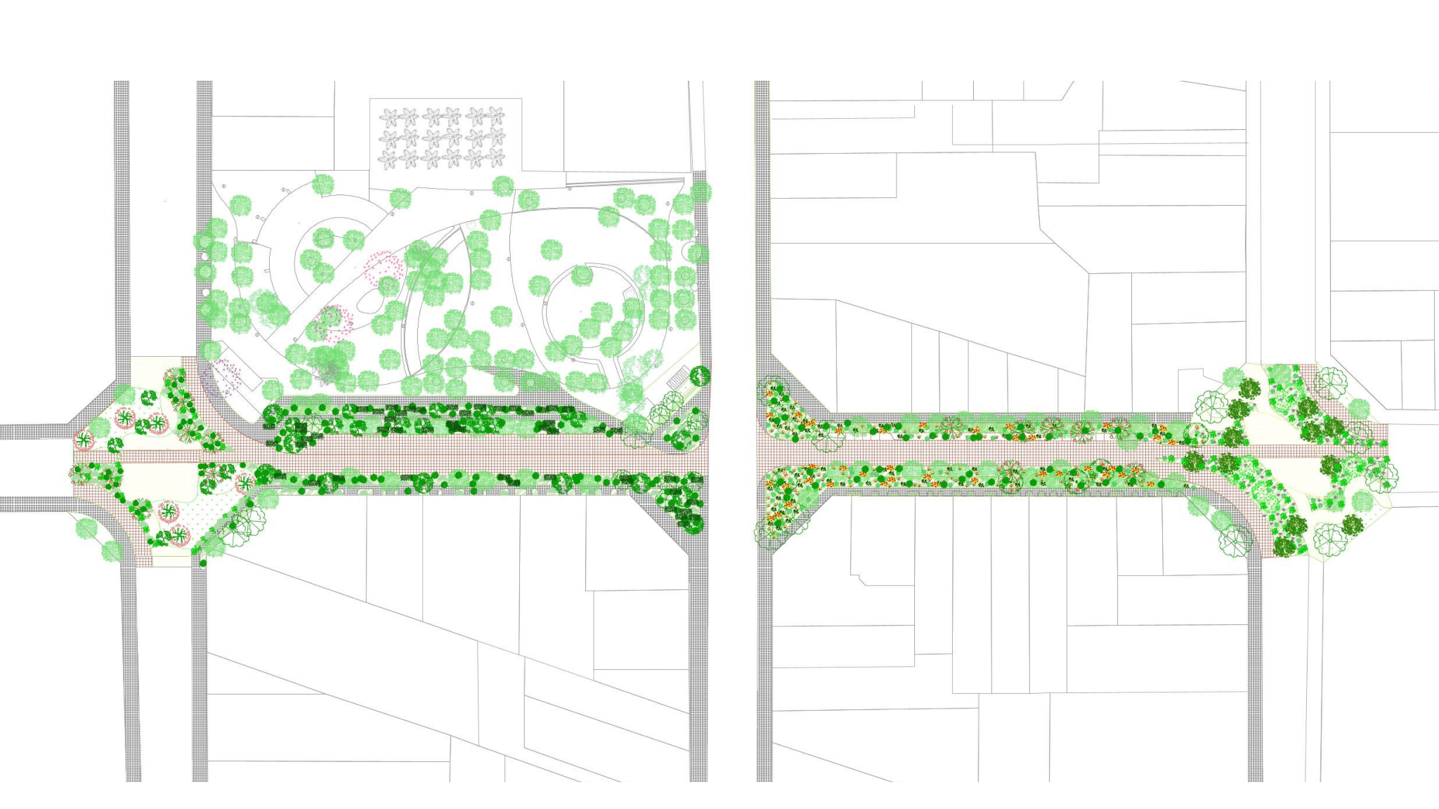
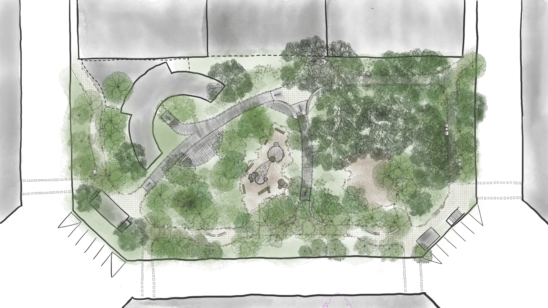
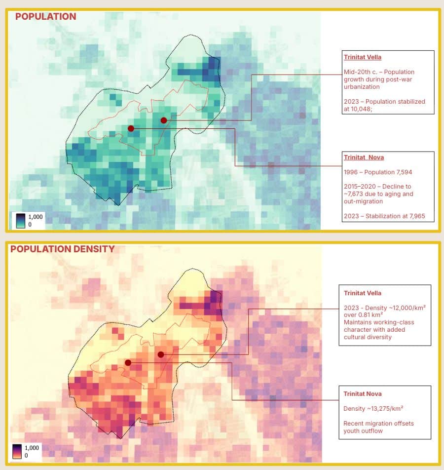
IAAC’s Master in City & Technology (1 or 2-year program) is a unique program oriented towards redefining the analysis, planning, and design of twenty-first-century cities and beyond. The program offers expertise in the design of digitally enhanced, ecological and human-centered urban environments by intersecting the disciplines of urbanism and data science. Taking place in Barcelona, the capital of urbanism, the Master in City & Technology is training the professionals that city administrations, governments, industries, and communities need, to transform the urban environment in the era of big data.


Filters
Course

in the pursuit of water

Guntur Panchayat, Trichy District Location: 10.7245103, 78.7281189Guntur lake was not maintained for years. After our restoration work the lake is now filled with water.  Peravurani Taluk, Thanjavur district, Tamilnadu Area of the lake: 6 acresWater storage capacity: 40000000 litresLocation: 79.25 ,10.27 athalaikkundu Nochchi Kulam Area of the lake: 55 acresWater storage capacity:80 crore litresLocation10.289601, 79.22789Shrubs and invasive … Read more

Do you [see] what [i] see?

We want to invite you to witness the city through a lens often overlooked, how people navigating urban spaces shaped by “intersectionalities”. This is a story about how people experience cities—specifically, the everyday places where we wait to catch a bus, hop on a train, or cross the street. These spots might seem ordinary, but … Read more

WHAT IS INFORMAL?

The Power of Community-Built Cities: Looking into a Bottom Up Approach Over 1.1 billion people live in what are often labeled as ‘informal settlements.’ Despite the vast scale and human impact of this issue, these communities remain largely overlooked in policy and investment decisions. This neglect may stem, in part, from the terminology itself: labels … Read more

Beyond the Formal: Alto Hospicio

Behind the scenes We began our story-making process using another research project as a jumping-off point. In another course, we explored the detection and analysis of informal settlements in Northern Chile through satellite imagery. We wanted to invert our perspective and work with the topic of informality from the perspective of experiencing life in camps … Read more

URBAN MORPHOLOGY + INFRASTRUCTURE

Petrópolis: Analysis & Strategic Responses for Flood-Vulnerable Contexts 1.1. History of the city Summary – 1.1. History of the City Petrópolis initially developed in valleys and along riverbeds, where construction was easier, but this laid the groundwork for future vulnerabilities. Located within the Atlantic Forest Biome, only 12.4% of its original forest remains due to … Read more

Topographical Risk + Geomorphology

Understanding the complexity of urban flooding Across the globe, cities are facing the increasingly visible consequences of climate change, with floods and landslides ranking among the most destructive urban hazards. In Brazil, the city of Petrópolis offers a critical lens through which to study the layered vulnerabilities of urban settlements exposed to extreme rainfall, unstable … Read more

Climate Vulnerability and Hydrology in Petropolis

This project investigates the hydrological dynamics and climate vulnerability contributing to severe flooding in Petropolis, Brazil. Focusing on rain-runoff behavior, impervious surface expansion, and topographic influence, the study examines how urbanization has intensified flood risk. A detailed analysis of precipitation patterns and surface drainage inefficiencies highlights the city’s exposure to extreme weather events. Hydrological modeling … Read more

Cesium: Visualizing the World in Unity

Creating a Visual Medium for the Visualization of Urban Data Using Cesium in Unity Engine for Geospatial VisualizationCesium for Unity bridges 3D geospatial data with Unity’s real-time development environment, enabling developers to create immersive, real-world simulations and applications. By integrating high-accuracy global datasets, 3D Tiles, and dynamic data feeds, it provides a robust framework for … Read more

Urbanism Around Landslides: A Remote Sensing Approach

The Landscape of Risk India has witnessed 3782 major landslides between 2015–2022.Regions like Himachal Pradesh, Uttarakhand, Kerala, and the North-East are especially vulnerable. Landslides disrupt cities, block roads, damage homes — and in some cases, like Wayanad in 2024, result in loss of lives and millions in damages. The Research Question How can remote sensing … Read more

VISUALISING VISIBILITY OF WOMEN+ SAFETY

Overview Visualizing Visibility of Women+ Safety is a research initiative aimed at evaluating how the design of public spaces influences perceptions of safety for women+ in India, particularly in Delhi. The central question driving this study is: “How can we assess the current paradigms of urban design to better understand and improve perceptions of safety … Read more

Living in Crisis: A Comparative Analysis of Spatial Strategies in Housing

This blog post presents a comparative study of spatial strategies in contemporary housing, using the concept of ‘islandisation’ as a critical lens. Islandisation, defined as a process of increasing detachment from interconnected networks, is explored across a range of case studies Introduction “The tension between isolation as systemic control versus isolation as protective communing raises … Read more

Democratizing Credit: Diving Deeper

City

Diving deeper into building a reliable rating algorithm The Importance & Significance of the F&B establishments in the City Food and Beverage (F&B) service outlets are significant indicators of urban progress as they reflect evolving consumer preferences, economic vitality, and the integration of social spaces within urban landscapes. These establishments act as hubs for community … Read more

Landscape as a Climate Catalyst

Climate Hope, Regenerative Agriculture and Soil Restoration Up to 40% of the world’s land is degraded Poor land management and conventional agricultural practices have degraded soils, reducing their ability to store carbon and absorb water, accelerating climate change and threatening food systems. Soils store 3x more carbon than the atmosphere, but 50-70% of their natural … Read more

AI Weather Assistant

As part of a collaborative exploration into creative automation and human-AI interaction, our team developed an AI-powered weather assistant that integrates live data, generative visuals, and contextual language processing into a single, responsive system. The assistant operates via a Telegram bot and delivers three core outputs: current weather information, clothing recommendations, and an AI-generated image … Read more