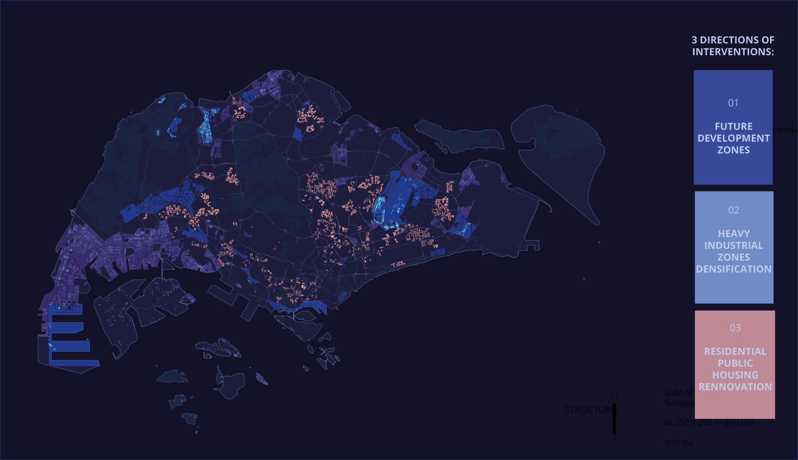
IAAC’s Master in City & Technology (1 or 2-year program) is a unique program oriented towards redefining the analysis, planning, and design of twenty-first-century cities and beyond. The program offers expertise in the design of digitally enhanced, ecological and human-centered urban environments by intersecting the disciplines of urbanism and data science. Taking place in Barcelona, the capital of urbanism, the Master in City & Technology is training the professionals that city administrations, governments, industries, and communities need, to transform the urban environment in the era of big data.
2016 NYC Yellow Cab trip
The source dataset provided for this project is derived from the 2016 NYC Yellow Cab trip records, which were made publicly available on the Big Query platform of the Google Cloud. The data was originally collected and published by the New York City Taxi and Limousine Commission (TLC). This dataset serves as the foundation for … Read more
New York City Taxi Trip Duration
INTRODUCTION The competition is based on the 2016 NYC Yellow Cab trip record dataset. The challenge is to build a model that predicts trip duration for New York City taxis using machine learning. The dataset includes pickup time, geo-coordinates, number of passengers, and several other variables. Based on individual trip attributes, a code was written … Read more
1st Traditional IAAC MaCT ML Competition
#Objective #A Kaggle Competition to MaCT01 students to show their knowledge, designing an end-to-end machine learning project to predict the “Trip Duration” of NYC Taxi trips. #Workflow #First of all a workflow hast do be developed, which represents a classic approach for training machine learning models, analysing the provided training data provided by the submission, … Read more
NYC Cab Trip Duration Prediction
The aim of the project is to predict trip duration, using 2016 NYC YELLOW CAB TRIP DATA. Structuring the dataset The analysis begins with outlier identification. The passenger_count variable has two outliers: 0 and 9, which compared to the amount of people allowed by the NY Limousine law, is impossible. Also, there were some pickup … Read more
Gridscape.ai
INTRODUCTION Urban planning decisions have a significant impact on the development of cities, and using machine learning can provide decision-makers with valuable insights to make informed decisions. By clustering urban areas based on various factors such as population density, built density, POI density, green cover, and build diversity, we can reveal spatial patterns that can … Read more
BullerbyNet
The Core challenges of urban childhood As cities grow and develop, there is often a lack of safe and child-friendly spaces for children to play, walk or bike alone. The increase in traffic and air pollution makes it challenging and unsafe for children to travel on foot or by bicycle. Crime and social fear also … Read more
BEYlink
RE-frame and Connect Public spaces in a city, such as pathways and non-constructible parcels, are not utilized to their full potential. As a result, they create voids and detachment of citizens from their city and do not provide any meaningful benefits to the community. Using machine learning algorithms as a tool for public organizations to … Read more
ONE MUMBAI!
Climate change is increasing the frequency and severity of extreme weather events, and cities like Mumbai with a population of over 12 million people, is particularly vulnerable to the impacts of climate change. In fact, studies have shown that Mumbai is one of the cities most at risk from rising sea levels more intense floods, … Read more
Meteo sanctum
The project reflects on how people in ancient times defined natural and weather phenomena. The proposal is to create an open public space – Inspired by the concept of an ancient sanctuary with places that used to be built for worship and predictions of weather conditions, the Meteo Sanctum consists of digital indicators that allow … Read more
Barcelona Cloud
Mixed use pavilion with dominant cultural function. Cultural venue Barcelona Cloud. Envisioned constraints: not less than 1/10 for public spaces on the North and South, permeable transit corridors the ground level for large groups of pedestrians, solar envelope by summer solstice and average height of neighborhood buildings restrict height and shape the shadowing canopy, trees … Read more
Bio-Digital Paths
“Bio-Digital Path” is a computational model of modular public spaces generated from emerging public movements within the existing urban fabric of Barcelona. Global challenges consist of both environmental threats, but also social challenges and this project suggests that planners and architects actually have the tools to construct the public space not as a separate but … Read more
Public Pulse
PROBLEM A lack of activities and engagement in certain streets can lead to a decrease in their vibrancy and vitality. This can manifest in empty streets, dilapidated buildings, and a dearth of social and cultural events. Over time, these areas may become less desirable places to live or visit, perpetuating the cycle of neglect and … Read more
MOBILITY FOOTPRINT
Introducing the Mobility Footprint, an interactive dashboard designed to promote awareness about mobility in urban environments and its impact on CO2 emissions. By selecting your typical mode of transportation and choosing from eight pre-determined destinations, the dashboard will provide you with a recommended route, estimated travel time, and the CO2 emissions associated with your selected … Read more
BE A SUPER CITIZEN!
INTRODUCTION Interactive design is a rapidly evolving field that has the potential to revolutionize the way we experience and interact with art and information. With advancements in technology, visual and multimedia artists now have the ability to create immersive and interactive exhibitions that engage the viewer on a whole new level. This changing state of … Read more