IAAC’s Master in City & Technology (1 or 2-year program) is a unique program oriented towards redefining the analysis, planning, and design of twenty-first-century cities and beyond. The program offers expertise in the design of digitally enhanced, ecological and human-centered urban environments by intersecting the disciplines of urbanism and data science. Taking place in Barcelona, the capital of urbanism, the Master in City & Technology is training the professionals that city administrations, governments, industries, and communities need, to transform the urban environment in the era of big data.


Filters
Course

Sunlit Streets, Shaded Paths

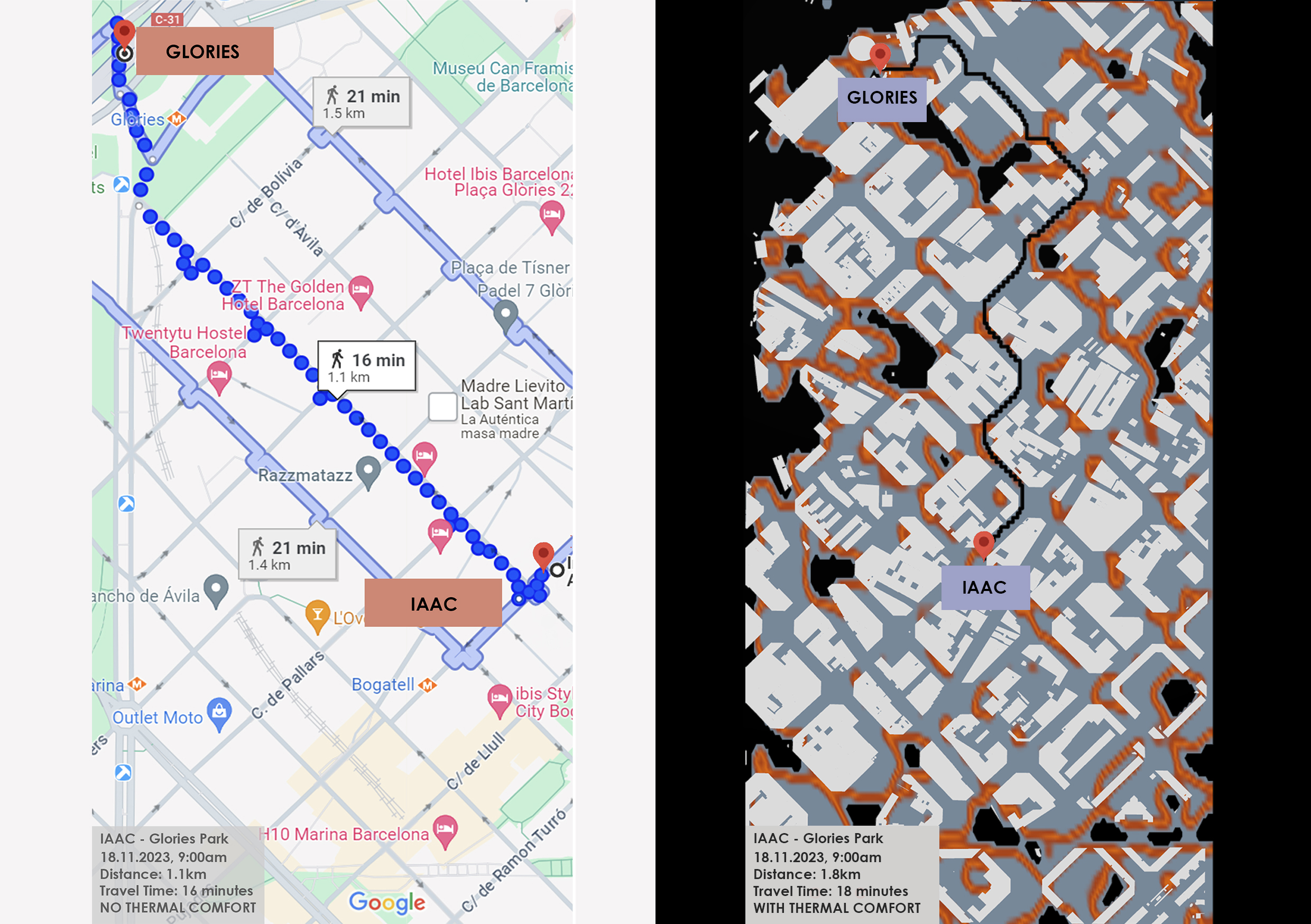
Computational Tools for Thermally Comfortable Walks in Barcelona On one of the sunniest days in the city of Barcelona, you want to go for a walk and get some fresh air but the heat from the sun makes you uncomfortable. Can you go for the walk without the sun making you completely sick? The objective … Read more

FloodZone Analytics

Introduction Water-related disasters, such as floods and droughts, have become increasingly frequent and severe due to climate change, representing significant global challenges. Urbanization and land use changes are contributing factors, with settlements in high flood-risk areas growing. In studying Milan and the Lambro river basin in Northern Italy, we observe increasing frequencies of floods, highlighting … Read more

Travelling Paris

Paris, often hailed as the world’s most popular tourist destination, beckons millions of visitors each year with its unparalleled blend of history, culture, gastronomy, and romance. At its heart stands the iconic Eiffel Tower, symbolizing the city’s architectural finesse and innovative spirit. The Louvre Museum, home to countless masterpieces, invites art aficionados to meander through … Read more

Mapping Airbnb data in San Francisco

Since its launch in 2007, Airbnb has revolutionized the hosting industry: By providing a simple and intuitive online platform, it connects millions of hosts and visitors worldwide. Born in The Bay, the app has changed the dynamics of the whole area, impacting sectors that extend from tourism to the housing market. Through the analysis of … Read more

Understanding the City through Data, Maps & Code

Finding the ratio of natural Green spaces to the Educational institutions in Barcelona city, Spain. TOOLS USED INTRODUCTION Barcelona, like many modern cities, has been actively working on providing open datasets to the public. Open datasets are valuable resources that foster transparency, innovation, and engagement within communities. Barcelona’s open datasets cover a wide range of topics, including urban … Read more

Worldwide cityscapes spatial analysis using OpenStreetMap Data

Introduction OpenStreetMap (OSM) stands as a testament to the power of collaborative mapping, where a community of volunteers comes together to create a detailed and constantly updated geographic database. This free and open resource is not just a map; it’s a versatile tool used for everything from navigation and humanitarian aid to data visualization. OpenStreetMap … Read more

Promised Land

Mesh representation of MIDI

Mapping America’s Genrescape Promised Land, Chuck Berry’s early representation of modern rock and roll, blurs racialized difference in genre origin, fueling the hybridization of genre categorizes, resulting in America’s current rich music tapestry. MIDI data correlated to synaesthetic representations of color is crystalized and in a dense three-dimensional mesh and place qualities are correlated to … Read more

Counting and displaying geographical information

Introduction Grasshopper, renowned for its prowess in visualization, presents a unique landscape of opportunities for those eager to dive deep into the realm of geographical information. This blog post presents the start of my journey with Grasshopper, highlighting its potential as well as the challenges and learning curves it presents. Objective: Gaining Confidence with Grasshopper … Read more

Visualization of Complex Innovation Data using Python

Innovation is a buzzword these days, and everyone seems to be talking about it. However, truly understanding it is a different ball game. Take the Global Innovation Index by the World Intellectual Property Organization (WIPO), for example. It’s a massive framework that pulls data from top-tier organizations worldwide, scoring countries on 100+ indicators. It’s a … Read more

Cities in Motion

Bogota Public Transport from GTFS

The General Transit Feed Specification (GTFS) is a standardized format designed for the distribution of public transport information globally. This format facilitates the integration of public transportation systems in cities worldwide with popular route planning platforms like Citymapper, Waze, or Moovit. By doing so, it enables users to access information on transport availability and plan … Read more

Can inequality of opportunity be mapped?

An exercise in visually corelating data. Introduction The Swedish educational system is based on merit. Students have to compete for places by means of their average grades. The competition is fierce, especially in large cities such as Stockholm. This project forms an attempt to showcase a possible correlation between the median acceptance grades of schools … Read more

Navigating Inequality

Introduction Wealth disparity leads to social and economic challenges resulting in social exclusion. 21.6% of population in the EU are at risk of social exclusion. A study confirmed that 61.7% of socially excluded people tend to be segregated. Understanding the origin of the word Segregation – initially used to set sheep apart from the flock, … Read more

Routing Accessibility

Background Public transportation plays a crucial role in urban planning globally. Extensive research indicates that bus transit has become a highly favored mass mobility system. This preference stems from its cost-effective infrastructure, flexible planning, and discrete architecture that supports incremental growth. Bus transit systems exhibit lower infrastructure costs compared to rail or subway networks, making … Read more

Environmental Asset Resilience

The Environmental Asset Resilience (EAR) Tool is a response to the pressing global challenge of environmental instability, particularly in urban areas. These areas face substantial costs associated with environmental problems and climate change. However, decision-making in addressing these issues is complicated by conflicting priorities, limited resources, and a lack of expertise. The EAR Project aims … Read more